Bottle Lake, New Zealand

Last updated

Bottle Lake
Bottle Lake Bottle Lake 100.JPG
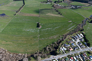
Demolition material from the 2011 Christchurch earthquake piled up in Bottle Lake Forest
Bottle Lake, New Zealand
Coordinates: 43°27′18″S172°39′58″E / 43.455°S 172.666°E / -43.455; 172.666
CountryNew Zealand
City Christchurch
Local authority Christchurch City Council
Electoral ward
  • Innes
  • Coastal
Belfast Kainga Spencerville
Northwood
Pfeil oben.svg
Pfeil links.svgBottle LakePfeil rechts.svg
Pfeil unten.svg
(Pegasus Bay)
Marshland Prestons Parklands

Bottle Lake is a suburb in the north-east of Christchurch with a low number of residents. Most of the suburb is covered by Bottle Lake Forest, which has since the mid-1970s become a popular recreation area.

The area was known as Waitikiri to Māori and the swamplands around a lake was a traditional mahinga kai (food gathering place). [1] Bottle Lake was first granted for grazing in 1853. [2] The area was bought as a sheep run by John McLean in 1860. [3] He sold the land after only two years to Edward Reece, who named his homestead Waitikiri after the Māori name for the area. Reece commissioned John Gibb to paint Bottle Lake about 20 years after he purchased the land. Reece died in 1885, and the painting was gifted to the Canterbury Society of Arts in 1902 by his son, William Reece. The oil painting is today owned by the Christchurch Art Gallery. [4]

Most of the area was purchased in 1878 by Christchurch City Council for waste disposal, but grazing continued into the next century. The pine plantation was begun in 1912, and the land was drained. [2] By the late 1930s, the lake had dried up. [3] The name of the lake was used for other purposes. The hospital board looked for a remote area where an infectious diseases hospital could be set up, and they established the Bottle Lake Hospital. This has since been renamed Burwood Hospital. The road leading to the hospital was originally called Bottle Lake Road and has since been changed to Burwood Road. The suburb that formed around the hospital took its later name—Burwood. [3]

The production forest was out of bounds, and the area was virtually unknown to Christchurch people. This changed in 1975, when the forest was given park status. It has since developed into a recreation area, with mountain biking, horse riding, and walking all very popular. [3] There is some housing on the fringes of Bottle Lake Forest, and Waitikiri Drive is a reminder of the area's original name.

The former landfill site within Bottle Lake was reopened after the February 2011 Christchurch earthquake to take an estimated 4.5 million tonnes of demolition material. [5]

Demographics

Styx statistical area, which also includes Kainga, covers 32.72 km2 (12.63 sq mi). [6] It had an estimated population of 1,080 as of June 2022, [7] with a population density of 33.0 people per km2.

Historical population
YearPop.±% p.a.
2006939    
20131,134+2.73%
20181,092−0.75%
Source: [8]

Styx had a population of 1,092 at the 2018 New Zealand census, a decrease of 42 people (-3.7%) since the 2013 census, and an increase of 153 people (16.3%) since the 2006 census. There were 480 households. There were 579 males and 513 females, giving a sex ratio of 1.13 males per female. The median age was 44.3 years (compared with 37.4 years nationally), with 177 people (16.2%) aged under 15 years, 180 (16.5%) aged 15 to 29, 588 (53.8%) aged 30 to 64, and 147 (13.5%) aged 65 or older.

Ethnicities were 91.5% European/Pākehā, 11.3% Māori, 1.9% Pacific peoples, 1.6% Asian, and 3.3% other ethnicities (totals add to more than 100% since people could identify with multiple ethnicities).

The proportion of people born overseas was 12.1%, compared with 27.1% nationally.

Although some people objected to giving their religion, 58.8% had no religion, 29.7% were Christian, 0.5% were Muslim, 0.5% were Buddhist and 3.0% had other religions.

Of those at least 15 years old, 102 (11.1%) people had a bachelor or higher degree, and 243 (26.6%) people had no formal qualifications. The median income was $33,900, compared with $31,800 nationally. The employment status of those at least 15 was that 483 (52.8%) people were employed full-time, 159 (17.4%) were part-time, and 27 (3.0%) were unemployed. [8]

Related Research Articles

<span class="mw-page-title-main">Waltham, New Zealand</span> Suburb in Christchurch, New Zealand

Waltham is an inner suburb of Christchurch, New Zealand, located approximately two kilometres south-east of the city centre. State Highway 76, part of Christchurch's ring road system, and known there as Brougham Street, runs through the suburb, as does the Lyttelton Line rail corridor.

<span class="mw-page-title-main">Belfast, New Zealand</span> Suburb in Christchurch, New Zealand

Belfast is a suburb of Christchurch, New Zealand. It is in the north of the city 10 km from Cathedral Square, close to the banks of the Waimakariri River.

<span class="mw-page-title-main">Riccarton, New Zealand</span> Suburb in Christchurch, New Zealand

Riccarton is a suburb of Christchurch. It is due west of the city centre, separated from it by Hagley Park. Upper Riccarton is to the west of Riccarton.

<span class="mw-page-title-main">Hornby, New Zealand</span> Suburb in Christchurch, New Zealand

Hornby is a major residential and retail suburb at the western edge of Christchurch, New Zealand. The suburb is directly connected to other parts of Christchurch and the South Island by a number of main arterial routes, including State Highway 1 and the Christchurch Southern Motorway.

<span class="mw-page-title-main">Avonside</span> Suburb in Christchurch, New Zealand

Avonside is an eastern suburb in Christchurch, New Zealand. It is one of the oldest suburbs of the city, with only Heathcote being older.

<span class="mw-page-title-main">Redwood, Christchurch</span> Suburb in Christchurch, New Zealand

Redwood is a suburb located in Christchurch, New Zealand which includes the sub-division of Redwood Springs. The suburb was first named Styx but renamed following a popular vote of local residents in the 1960s after a large Sequoia redwood tree still standing in Prestons Road. The original forest cover was Totara and Kahikatea. Redwood has its own community radio station called Good Music FM 107.5.

<span class="mw-page-title-main">Spencerville, New Zealand</span> Suburb of Christchurch, New Zealand

Spencerville is a semi-rural town on the east coast of Canterbury, New Zealand north of Christchurch. The town backs on to Bottle Lake Forest and includes a large park and 80 hectare camping ground. These amenities, as well as wetlands and an animal and bird park make the town a popular camping area for Christchurch residents.

<span class="mw-page-title-main">Burwood, New Zealand</span> Suburb in Christchurch, New Zealand

Burwood is a north-eastern suburb of Christchurch, New Zealand. The suburb is mostly a residential area and is centred on Burwood Hospital, Travis Wetland Nature Heritage Park and Bottle Lake Forest.

<span class="mw-page-title-main">Strowan</span> Suburb in Christchurch, New Zealand

Strowan is an affluent suburb of Christchurch, New Zealand, located approximately 5 km north-west of Christchurch's central business district. It had a population of 3,705 at the 2013 census. It is located between the suburbs of Merivale, Papanui, Bryndwr, Fendalton, and St Albans.

<span class="mw-page-title-main">Dallington, New Zealand</span> Suburb in Christchurch, New Zealand

Dallington is a suburb of Christchurch, New Zealand, on the north-east side of the city.

<span class="mw-page-title-main">Maori Hill</span> Suburb of Dunedin, New Zealand

Māori Hill is a residential suburb of the New Zealand city of Dunedin. It is located at the northern end of the ridge which runs in a crescent around the central city's western edge, 2 kilometres (1.2 mi) to the northwest of the city centre, immediately above and within the Town Belt. It is connected to Dunedin North, which lies to the east, via Drivers Road, the suburbs of Roslyn and Kaikorai to the southwest via Highgate, and the suburb of Wakari to the northwest via Balmacewen Road.

Hoon Hay is an outer suburb of Christchurch, New Zealand, located at the base of the Port Hills and about 5 kilometres (3.1 mi) southwest of Cathedral Square. The area was named by Captain Wickham Talbot Harvey, a captain of the British Royal 10th Hussars, who moved to the area in 1852 and named it after the farm near Hatton, Derbyshire where he grew up. Harvey only stayed in the area for four years, before a fire destroyed his property and prompted him to return to the United Kingdom. Further fires in the following years destroyed the woodland which was on the property, including several large Tōtara, causing it to be converted into farmland. Remnants of this forest remain visible in the area, including with tree stumps being discovered during flood mitigation work on the Ōpāwaho / Heathcote River.

<span class="mw-page-title-main">Parklands, New Zealand</span> Suburb in Christchurch, New Zealand

Parklands is a suburb of Christchurch, New Zealand. It is located north east of the city centre near Bottle Lake Forest.

<span class="mw-page-title-main">Brooklands, Christchurch</span> Suburb in Christchurch, New Zealand

Brooklands is the northernmost suburb of Christchurch, New Zealand. The settlement was built on former swamp land adjacent to Brooklands Lagoon, which forms part of the Waimakariri River mouth. The land damage sustained in the 2010 and 2011 Christchurch earthquakes and subsequent Red Zone classification resulted in the buyout and demolition of nearly all properties in Brooklands, effectively wiping the suburb off the map.

<span class="mw-page-title-main">Hillsborough, Christchurch</span> Suburb in Christchurch, New Zealand

Hillsborough is a mixed industrial and residential suburb of Christchurch, New Zealand, located approximately 4 kilometres (2.5 mi) to the south-east of the city centre.

<span class="mw-page-title-main">Kainga, New Zealand</span> Place in Canterbury, New Zealand

Kainga is a settlement on the southern bank of the Waimakariri River, just north of Christchurch, in Canterbury, New Zealand. It lies immediately to the south of Kaiapoi, on a small road leading northeast from SH 1

<span class="mw-page-title-main">Hillmorton, New Zealand</span> Suburb in Christchurch, New Zealand

Hillmorton is a suburb of south-western Christchurch, New Zealand. The suburb is centred around the intersection of Lincoln Road and Hoon hay Road, two arterial routes which form part of State Highway 75 and feed into the Christchurch Southern Motorway which runs to the north of the suburb.

<span class="mw-page-title-main">Northwood, New Zealand</span> Suburb in Christchurch, New Zealand

Northwood is a suburb on the northern outskirts of Christchurch city. It was developed in 2000 as a subdivision of Belfast on land previously used for apple orchards. The name "Northwood" was accepted at a meeting of the Shirley-Papanui Community Board on 2 February 2000.

<span class="mw-page-title-main">Marshland, New Zealand</span> Suburb in Christchurch, New Zealand

Marshland is a semi-rural suburb on the northern side of Christchurch city. The land is primarily used for horticulture and dairy farming.

Northcote is a suburb on the northern side of Christchurch, New Zealand.

References

  1. Vangioni, Peter (11 January 2016). "An early impression of Bottle Lake". The Press . p. A4.
  2. 1 2 Harper, Margaret (December 2015). "Christchurch Place Names: A - M" (PDF). Christchurch City Libraries. p. 38. Retrieved 30 January 2016.
  3. 1 2 3 4 "Bottle Lake and Waitikiri: the early years". Christchurch City Libraries . Retrieved 29 January 2016.
  4. "Bottle Lake". Christchurch Art Gallery. Archived from the original on 30 January 2016. Retrieved 29 January 2016.
  5. Heather, Ben (24 November 2011). "Park to be a permanent dump". The Press . Retrieved 28 February 2014.
  6. "ArcGIS Web Application". statsnz.maps.arcgis.com. Retrieved 7 September 2021.
  7. "Population estimate tables - NZ.Stat". Statistics New Zealand . Retrieved 25 October 2022.
  8. 1 2 "Statistical area 1 dataset for 2018 Census". Statistics New Zealand. March 2020. Styx (317200). 2018 Census place summary: Styx