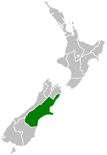
Canterbury is a region of New Zealand, located in the central-eastern South Island. The region covers an area of 44,508 square kilometres (17,185 sq mi), and is home to a population of 645,900.

Christchurch is the largest city in the South Island of New Zealand and the seat of the Canterbury Region. Christchurch lies on the South Island's east coast, just north of Banks Peninsula on Pegasus Bay. The Avon River flows through the centre of the city, with an urban park located along its banks. The city's territorial authority population is 394,700 people, and includes a number of smaller urban areas as well as rural areas. The population of the urban area is 383,200 people. Christchurch is the second-largest city by urban area population in New Zealand, after Auckland. Christchurch is the major urban area of an emerging sub-region known informally as Greater Christchurch. Notable smaller urban areas within this sub-region include Rangiora and Kaiapoi in Waimakariri District, north of the Waimakariri River, and Rolleston and Lincoln in Selwyn District to the south.

Lyttelton is a port town on the north shore of Lyttelton Harbour, at the northwestern end of Banks Peninsula and close to Christchurch, on the eastern coast of the South Island of New Zealand. According to the 2013 census, Lyttelton had a usual resident population of 2,859.

The Ōpāwaho / Heathcote River lies within the city boundaries of Christchurch, New Zealand, and is fed from springs near Templeton Road, with a catchment area in wet weather extending as far west as Yaldhurst and Pound Road. It meanders around the base of the Port Hills from west to south-east.

Woolston is a light industrial and residential suburb of Christchurch in the South Island of New Zealand. It is situated three kilometres southeast of the city centre, close to major arterial routes including State Highways 74 and 76 to Banks Peninsula. The Heathcote River flows through the suburb.
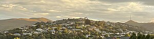
Cashmere is a suburb which rises above the southern end of the city of Christchurch in New Zealand's South Island.

Sydenham is an inner suburb of Christchurch, New Zealand, two kilometres south of the city centre, on and around the city's main street, Colombo Street. It is a residential, retail and light industrial suburb.

Khandallah is a suburb of Wellington, the capital city of New Zealand. It is located 4 kilometres (2.5 mi) northeast of the city centre, on hills overlooking Wellington Harbour.

The Christchurch Botanic Gardens, located in the central city of Christchurch, New Zealand, were founded in 1863 when an English oak was planted to commemorate the solemnisation of the marriage of Prince Albert and Princess Alexandra of Denmark. The Gardens sprawl over an area of 21 hectares and lie adjacent to the loop of the Avon River next to Hagley Park. The Christchurch Botanic Gardens have a variety of collections of exotic and local plants of New Zealand, several conservatories, a nursery, playground and Climatological Station.

Cashmere High School is a state coeducational secondary school, located in southern Christchurch, New Zealand. It was opened in 1956 in response to population growth in southern Christchurch during the 1950s.

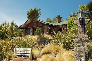
Rolleston is the seat and largest town in the Selwyn District, in the Canterbury region of New Zealand's South Island. It is located on the Canterbury Plains 22 kilometres (14 mi) south-west of Christchurch, and is considered a satellite town of the city. The town has a population of 21,900, making it New Zealand's 26th-largest urban area and the third-largest in Canterbury. It was nicknamed the "Town of the Future" in the 1970s by Prime Minister Norman Kirk. The "Town of the Future" signage has since been removed from the entrances to Rolleston.

Bryndwr is a suburb in the north-west of Christchurch, New Zealand.
Spreydon is a suburb of Christchurch, New Zealand, 4 kilometres (2.5 mi) south-south-west of Cathedral Square. The most central street through Spreydon is Barrington Street. Spreydon is flanked by the suburbs Hoon Hay, Sydenham, and Lower Cashmere. State Highway 76 marks the northern boundary of the suburb, including the eastern end of the Christchurch Southern Motorway.
Beckenham is an inner suburb of Christchurch, New Zealand, located three kilometres south of the city centre. The Ōpāwaho / Heathcote River winds through this predominantly residential suburb, a section of which is often referred to locally as the "Beckenham Loop". Beckenham is bounded by Sydenham to the north, Somerfield to the west, Cashmere and Huntsbury to the south and St Martins to the east.
St Martins is an inner suburb of Christchurch, New Zealand, located two kilometres south of the city centre. Primarily a residential area, St Martins is host to a small shopping mall complex situated on Wilsons Road, the main thoroughfare through the suburb.
Redcliffs is an outer coastal suburb of Christchurch, Canterbury, New Zealand.
Hoon Hay is an outer suburb of Christchurch, New Zealand, located at the base of the Port Hills and about 5 kilometres (3.1 mi) southwest of Cathedral Square. The area was named by Captain Wickham Talbot Harvey, a captain of the British Royal 10th Hussars, who moved to the area in 1852 and named it after the farm near Hatton, Derbyshire where he grew up. Harvey only stayed in the area for four years, before a fire destroyed his property and prompted him to return to the United Kingdom. Further fires in the following years destroyed the woodland which was on the property, including several large Tōtara, causing it to be converted into farmland. Remnants of this forest remain visible in the area, including with tree stumps being discovered during flood mitigation work on the Ōpāwaho / Heathcote River.

Maungakawa is located in the Waipa District, in the present day Te Miro settlement, northeast of the town of Cambridge, New Zealand. It was once the meeting place of the Kauhanganui, the parliament of the Kīngitanga and Waikato Tainui government. During the 1860s it had a population of several hundred. King Tawhiao opened a parliament building in 1891.
Viola Helen Macmillan Brown was an artist from Christchurch, New Zealand.
Hillmorton is a suburb of south-western Christchurch, New Zealand. The suburb is centred around the intersection of Lincoln Road and Hoon hay Road, two arterial routes which form part of State Highway 75 and feed into the Christchurch Southern Motorway which runs to the north of the suburb. It is the location of a number of schools, including Hillmorton High School, Rowley Avenue School and Spreydon School.