Lake Waipori

Last updated

Lake Waipori
Waipori.jpg
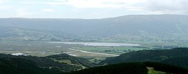
The lake and its surrounding wetlands, seen from the hills to the southeast. The Sinclair Wetlands are to the left of the picture.
Otago Map Physical New Zealand.jpg
Red pog.svg
Lake Waipori
Location South Island
Coordinates 45°58′S170°07′E / 45.967°S 170.117°E / -45.967; 170.117 Coordinates: 45°58′S170°07′E / 45.967°S 170.117°E / -45.967; 170.117
Type Natural freshwater lake
Primary inflows Waipori River
Primary outflows Waipori River
Basin  countriesNew Zealand
Max. length2.4 km (1.5 mi)
Max. width1.52 km (0.94 mi)

Lake Waipori is the smaller and shallower of the pair of lakes located in the wetlands to the south west of Dunedin in New Zealand on the Waipori River. [1] The Waipori River is a major tributary of the Taieri River, and these wetlands form the southern edge of the Taieri Plains. [2]

The lake is inhabited by various waterfowl and wetland birds. [3] [4] It is however too shallow and inaccessible (due to being surrounded with wetlands) to allow for recreation other than fishing and duck hunting in season. [5]

It is possible to travel from the Waipori River at Berwick through the lake and through to Lake Waihola in a flat bottomed dinghy or jetboat. [6] The lake is too shallow for other forms of motorboat. [6]

The lake is bordered to the southwest by the Sinclair Wetlands. [7]

Related Research Articles

<span class="mw-page-title-main">Henley, New Zealand</span> Human settlement in Dunedin City, Otago Region, New Zealand

Henley is a township on New Zealand's Taieri Plains, named after the rowing centre Henley-on-Thames in England. It lies close to the confluence of the Taieri and Waipori Rivers at the eastern edge of the plain, at the foot of a low range of coastal hills. The township lies close to the ecologically significant Sinclair Wetlands, which lie 3.5 kilometres (2.2 mi) to the west.

<span class="mw-page-title-main">Ahaura River</span> River in the South Island of New Zealand

The Ahaura River is in the South Island of New Zealand. This river drains the western flanks of the Southern Alps and flows into the Grey River.

<span class="mw-page-title-main">Awarau River</span> River in New Zealand

The Awarau River, usually known as Larry's Creek is located within the South Island of New Zealand. The river is about 27 kilometres (17 mi) long and runs northwest from its headwaters in the Victoria Range to its confluence with the Inangahua River north of Reefton. It also drains part of the Brunner Range and there was a track along that range linking to Lyell by 1901, though none existed in 1874. A track also ran south over Kirwan Hill to the Montgomerie River.

<span class="mw-page-title-main">Mosgiel</span> Town in Otago, New Zealand

Mosgiel is an urban satellite of Dunedin in Otago, New Zealand, fifteen kilometres west of the city's centre. Since the re-organisation of New Zealand local government in 1989 it has been inside the Dunedin City Council area. Mosgiel has a population of approximately 14,500 as of June 2022. The town celebrates its location, calling itself "The pearl of the plain". Its low-lying nature does pose problems, making it prone to flooding after heavy rains. Mosgiel takes its name from Mossgiel Farm, Ayrshire, the farm of the poet Robert Burns, the uncle of the co-founder in 1848 of the Otago settlement, the Reverend Thomas Burns.

<span class="mw-page-title-main">Taieri River</span> River in New Zealand

The Taieri River is the fourth-longest river in New Zealand and is in Otago in the South Island. Rising in the Lammerlaw Range, it initially flows north, then east around the Rock and Pillar range before turning southeast, reaching the sea 30 kilometres (19 mi) south of Dunedin.

<span class="mw-page-title-main">Lake Waihola</span> Lake in the South Island of New Zealand

Lake Waihola is a 640 ha tidal freshwater lake located 15 km north of Milton in Otago, in New Zealand's South Island. Its area is some 9 square kilometres, with a maximum length of 6 kilometres and a mean depth of 0.75m.

<span class="mw-page-title-main">Taieri Plain</span>

The Taieri Plain is an area of fertile agricultural land to the southwest of Dunedin, in Otago, New Zealand. The plain covers an area of some 300 square kilometres, with a maximum extent of 30 kilometres. It is not to be confused with Strath Taieri, a second plain of the Taieri River, 40kms to the north beyond Mount Ross.

<span class="mw-page-title-main">Waipori River</span>

The Waipori River is in Otago in the South Island of New Zealand. Rising in the Lammerlaw Range, it flows southeast for 50 kilometres (31 mi) before joining the Taieri River near Henley, 30 kilometres (19 mi) southwest of Dunedin of which it is officially the southernmost border. Google Maps erroneously shows the stretch of Taieri river from the confluence to the mouth as Waipori River. The correct name is shown on the New Zealand government's official NZ Topo Map.

South Otago lies in the south east of the South Island of New Zealand. As the name suggests, it forms the southernmost part of the geographical region of Otago.

<span class="mw-page-title-main">Maungatua</span>

Maungatua, known also as Maukaatua is a prominent ridge in the Taieri Plains in Otago, New Zealand.

<span class="mw-page-title-main">Lake Mahinerangi</span> Body of water

Lake Mahinerangi is a lake formed when a dam was built on the Waipori River for hydroelectric generation. The lake is 35 kilometres (22 mi) to the west of Dunedin in New Zealand's South Island. Construction of the dam started in 1903 and since 1907, power has been produced.

<span class="mw-page-title-main">Taieri Mouth</span> Rural settlement in Otago, New Zealand

Taieri Mouth is a small fishing village at the mouth of the Taieri River, New Zealand. Taieri Island (Moturata) lies in the ocean several hundred metres off the river's mouth.

<span class="mw-page-title-main">Clutha District</span> Territorial authority district in Otago, New Zealand

Clutha District is a local government district of southern New Zealand, with its headquarters in the Otago town of Balclutha. The Clutha District has a land area of 6,334.47 km2 (2,445.75 sq mi) and an estimated population of 18,650 as of June 2022. Clutha District occupies the majority of the geographical area known as South Otago.

<span class="mw-page-title-main">Lake Tuakitoto</span> Body of water

Lake Tuakitoto is a small lake in South Otago, in the South Island of New Zealand. It is located to the northeast of Balclutha, close to the small town of Kaitangata. The smallest of South Otago's three main lakes, it is, like the others very shallow. The lake drains into the lower reaches of the Clutha River.

Otago Regional Council (ORC) is the regional council for Otago in the South Island of New Zealand. The council's principal office is Regional House on Stafford Street in Dunedin with 250-275 staff, with smaller offices in Queenstown and Alexandra. They are responsible for sustainably managing Otago’s natural resources of land, air and water on behalf of the community. Property owners pay rates to both the local and regional council. In June 2022 the council approved an annual plan of $109 Million dollars for 2022-2023 with an 18% rates rise.

<span class="mw-page-title-main">Eldon's galaxias</span> Species of fish

Eldon's galaxias is an endangered galaxiid fish endemic to New Zealand. One of several fishes in the genus Galaxias found in Central Otago, it has a very small home range and is at risk of being driven to extinction by trout introduced for recreational fishing.

<span class="mw-page-title-main">Waihola</span> Town in Otago, New Zealand

The township of Waihola lies between Dunedin and Milton, New Zealand in Otago, in New Zealand's South Island. It lies close to the southeast shore of the shallow tidal lake which shares its name.

Lake Tatawai was a tidal freshwater lake located immediately north of Lake Waipori in Otago, in New Zealand's South Island.

Hawksbury Lagoon is situated within the East Otago town of Waikouaiti, on the northern boundary of Dunedin City, New Zealand.

References

  1. "Waipori/Waihola Wetland Complex". www.orc.govt.nz. Retrieved 19 May 2021.
  2. Schallenberg, Marc; Burns, Carolyn W.; Peake, Barrie M. (June 2003). "A temperate, tidal lake‐wetland complex 1. Water balance and ecological implications". New Zealand Journal of Marine and Freshwater Research. 37 (2): 415–428. doi: 10.1080/00288330.2003.9517177 . ISSN   0028-8330.
  3. "Waihola Waipori Wetlands". www.doc.govt.nz. Retrieved 19 May 2021.
  4. Cromarty, Pam (1996). Scott, Derek A. (ed.). A directory of wetlands in New Zealand : Otago Conservancy (PDF). Wellington, N.Z.: Department of Conservation. pp. 315–321. ISBN   0-478-01776-6. OCLC   38890560.
  5. "Waipori/Waihola Wetland Complex". www.orc.govt.nz. Retrieved 19 May 2021.
  6. 1 2 Egarr, C.D.; Egarr, J. H. (1981). "New Zealand recreational river survey : an investigation into the recreational potential of New Zealand's inland waterways" (PDF). Water & Soil Miscellaneous Publication. 15: 92 via NIWA.
  7. Harwood, Brenda (4 February 2021). "Job scheme gives wetlands a boost". Otago Daily Times Online News. Retrieved 19 May 2021.