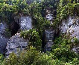
Paparoa National Park is on the west coast of the South Island of New Zealand. The park was established in 1987 and encompasses 430 km2 (170 sq mi). The park ranges from or near the coastline to the peaks of the Paparoa Range. A separate section of the park lies to the north and is centred at Ananui Creek. The park protects a limestone karst area. The park contains several caves, of which Metro Cave / Te Ananui Cave is a commercial tourist attraction. The majority of the park is forested with a wide variety of vegetation. The park was the site of the 1995 Cave Creek disaster where fourteen people died as a result of the collapse of a scenic viewing platform.
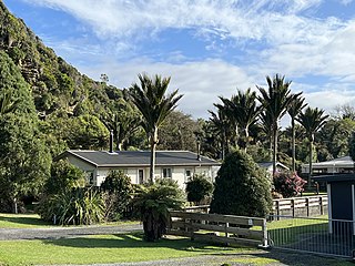
Punakaiki is a small village on the West Coast of the South Island of New Zealand. It is located between Westport and Greymouth on State Highway 6, the only through-road on the West Coast. Punakaiki is immediately adjacent to Paparoa National Park, and is also the access point for a popular visitor attraction, the Pancake Rocks and Blowholes.

The Heaphy Track is a popular tramping and mountain biking track in the north west of the South Island of New Zealand. It is located within the Kahurangi National Park and classified as one of New Zealand's ten Great Walks by the Department of Conservation. Named after Charles Heaphy, the track is 78.4 kilometres (48.7 mi) long and is usually walked in four or five days. The track is open for shared use with mountain bikers in the winter season from 1 May to 30 September each year. The southern end of the track is at Kōhaihai, north of Karamea on the northern West Coast, and the northern end is in the upper valley of the Aorere River, Golden Bay.
The Cave Creek disaster occurred on 28 April 1995 when a scenic viewing platform in Paparoa National Park, New Zealand, collapsed, resulting in the deaths of 14 people. The victims, 13 of whom were Tai Poutini Polytechnic students, fell 40 metres (130 ft) onto rocks below. The tragedy resulted in wide criticism of the government and its policies towards funding and management of the conservation estate. Denis Marshall, New Zealand's Minister of Conservation, eventually resigned, after the Commission of Inquiry's report came out. It also resulted in major changes to procedures used by the New Zealand Department of Conservation after it was revealed that serious systemic failures had led to the building of the unstable platform. Eventual changes in New Zealand law, following a change of government, allowed for government departments to be held criminally liable for inadequate building practices, in the same way as non-government organisations.

The Pororari River, with an older spelling of Porarari, is a river of the West Coast Region of New Zealand's South Island. It flows northwest from its sources in the Paparoa Range, reaching the Tasman Sea at Punakaiki via Pororari Lagoon. Cave Creek / Kotihotiho is a tributary to the river. There are opportunities to tramp along this river, with two different options accommodating multi-hour loop walks. Further upstream, the Pororari River is followed by the new Paparoa Track, which provides an opportunity for multi-day tramping or mountain biking.

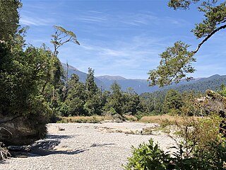
The Punakaiki River is a river of the West Coast Region of New Zealand's South Island. It flows predominantly northwest from its sources in the Paparoa Range, reaching the Tasman Sea two kilometres south of the town of Punakaiki. Most of the river's length is within Paparoa National Park.

The Fox River is a river in the Buller District of New Zealand. It arises in the Paparoa Range near Mount Dewar and flows north-west through the Paparoa National Park to the Tasman Sea at Woodpecker Bay. The river passes through a spectacular gorge. The northern branch of the river has limestone caves containing stalactite and stalagmite formations.
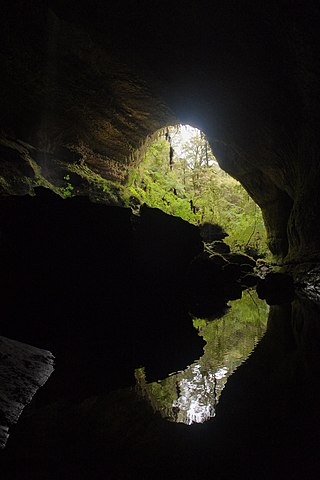
The Metro / Te Ananui Caves are a maze of limestone caves formed by the underground capture of Ananui Creek, a tributary of the Waitakere / Nile River. The caves are located in the Paparoa National Park in New Zealand, managed by the Department of Conservation. Parts of the cave system are accessible by cave tours and rafting, operated by a commercial tour operator out of Charleston.

The Paparoa Track is a 55.7 km (34.6 mi) shared hiking and mountain biking track located in Paparoa National Park in the South Island of New Zealand. The track was created as a memorial for the 29 miners who lost their lives in the Pike River Mine disaster. The track is the tenth Great Walk to be created and has been fully open since 1 March 2020. It was the first addition to the Great Walks in 25 years.

Lake Gault is a small glacial lake in South Westland, New Zealand, near the township of Fox Glacier. A walking track from Lake Matheson leads to the lake, which is surrounded by mature native forest. A small hydro-electric power plant was constructed piping water from the lake to power a gold mining dredge at Gillespies Beach. Endangered Ōkārito kiwi (rowi) have been released into the wild around Lake Gault.

Cave Creek / Kotihotiho is a small river within Paparoa National Park, on the West Coast of New Zealand's South Island.

Punakaiki Marine Reserve is a marine reserve administered by the Department of Conservation. The reserve includes the area of sea surrounding the pancake rocks and blowholes at Dolomite Point, at Punakaiki on the West Coast Region of New Zealand's South Island. It also includes most of the coastline on the western edge of Paparoa National Park.

The Truman Track is a short, easy walking track located north of Punakaiki, in the coastal Paparoa National Park in the South Island of New Zealand. Although only 600 m (2,000 ft) long, it has been described as "one of the most delightful and interesting short walks on the West Coast". The track passes through lowland coastal forest of podocarps, rātā trees and nīkau palms, with dense understorey vegetation. It finishes at the coastline, where there is a viewing platform providing views along the coast, with surrounding cliffs, rock overhangs, and a waterfall that cascades directly onto the beach.
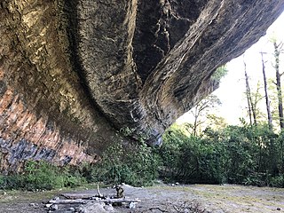
The Ballroom Overhang is a large limestone outcrop on the Fox River in Paparoa National Park, in the Buller District of New Zealand. The Ballroom Overhang provides a sheltered place for resting or overnight camping. The overhang is 10 m (33 ft) at its highest point, 100 m (330 ft) long, and 30 m (98 ft) at its widest point.

The Pancake Rocks and Blowholes are a coastal rock formation at Punakaiki on the West Coast of the South Island of New Zealand. They are a popular visitor attraction.
Bullock Creek or Punungairo is a river valley in the Paparoa National Park, located just north of Punakaiki on the West Coast of New Zealand. It includes a rare and nationally significant polje, a large, flat-floored depression within karst limestone. The Bullock Creek polje is New Zealand's only example of this type of landform.

The Croesus Track is a 22.1 km (13.7 mi) historic miners trail to the south of Paparoa National Park in the Grey District of South Island of New Zealand. The route crosses the Paparoa Range from Blackball in the Grey Valley to Barrytown on the Tasman Sea coast. The first section, starting from the Blackball end, is shared with the Paparoa Track which follows the route of the Croesus Track to top of the Paparoa Range. This section is shared-use between hiking and mountain biking.

The Pike29 Memorial Track is a hiking track located near the Paparoa National Park in the Grey District of the South Island of New Zealand. The track was created as a memorial for the 29 miners who lost lives in the Pike River Mine disaster. The track is a branch of the Paparoa Track, the tenth Great Walk created. Both tracks were originally scheduled to open in 2018. The Pike29 Memorial Track opened in February 2024, four years after the Paparoa Track. The Pike River Mine portal features a memorial and interpretation centre.

The Waitakere / Nile River is a river on the West Coast of New Zealand's South Island. It rises in the Paparoa Range and flows through a limestone karst landscape in a roughly northwest direction for its entire length, reaching the Tasman Sea just north of Charleston. The river and its surrounds are a popular tourist destination, particularly for a bush train along the river's canyon and caving through the nearby Metro / Te Ananui Caves. The lower reaches of the river are also a popular fishing spot, particularly for brown trout.

The Wangapeka Track is a tramping track in the north-west of the South Island of New Zealand. It is one of the main tramping tracks in the Kahurangi National Park, a protected area managed by the Department of Conservation. The route traverses the southern end of the park, from the historic Wangapeka goldfields area west of Tapawera, to the coastal plains of the West Coast at Little Wanganui. The route is 59 km (37 mi) long, and crosses the Wangapeka and Little Wanganui saddles, each over 1,000 m (3,300 ft) in elevation. The track passes through the valleys of the Wangapeka River, Karamea River, Taipō River and Little Wanganui River. The majority of the track is in river valleys and under forest cover, with small sections in tussock land at Stag Flat and the Little Wanganui Saddle. It typically takes walkers 4–6 days to complete the route.