
Paparoa National Park is on the west coast of the South Island of New Zealand. The park was established in 1987 and encompasses 430 km2 (170 sq mi). The park ranges from or near the coastline to the peaks of the Paparoa Range. A separate section of the park lies to the north and is centred at Ananui Creek. The park protects a limestone karst area. The park contains several caves, of which Metro Cave / Te Ananui Cave is a commercial tourist attraction. The majority of the park is forested with a wide variety of vegetation. The park was the site of the 1995 Cave Creek disaster where fourteen people died as a result of the collapse of a scenic viewing platform.
Punakaiki is a small village on the West Coast of the South Island of New Zealand. It is located between Westport and Greymouth on State Highway 6, the only through-road on the West Coast. Punakaiki is immediately adjacent to Paparoa National Park, and is also the access point for a popular visitor attraction, the Pancake Rocks and Blowholes.

The Westland petrel(Procellaria westlandica),, also known as the Westland black petrel, is a moderately large seabird in the petrel family Procellariidae, that is endemic to New Zealand. Described by Robert Falla in 1946, it is a stocky bird weighing approximately 1,100 grams (39 oz), and is one of the largest of the burrowing petrels. It is a dark blackish-brown colour with black legs and feet. It has a pale yellow bill with a dark tip.

The Paparoa Range is a mountain range in the West Coast region of New Zealand's South Island. It was the first New Zealand land seen by a European – Abel Tasman in 1642. Part of the range has the country's highest protection as a national park; the Paparoa National Park was established in 1987. Within that park, the Cave Creek disaster occurred in 1995.
Grey Valley is a former parliamentary electorate in the West Coast region of New Zealand. The electorate was created for the 1871 general election as a single-member electorate, became a two-member electorate for the 1876 general election, and was split between the single-member electorates of Greymouth and Inangahua for the 1881 general election.

The Pororari River, with an older spelling of Porarari, is a river of the West Coast Region of New Zealand's South Island. It flows northwest from its sources in the Paparoa Range, reaching the Tasman Sea at Punakaiki via Pororari Lagoon. Cave Creek / Kotihotiho is a tributary to the river. There are opportunities to tramp along this river, with two different options accommodating multi-hour loop walks. Further upstream, the Pororari River is followed by the new Paparoa Track, which provides an opportunity for multi-day tramping or mountain biking.

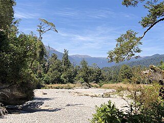
The Fox River is a river in the Buller District of New Zealand. It arises in the Paparoa Range near Mount Dewar and flows north-west through the Paparoa National Park to the Tasman Sea at Woodpecker Bay. The river passes through a spectacular gorge. The northern branch of the river has limestone caves containing stalactite and stalagmite formations.

The Nelson Coast temperate forests is an ecoregion in New Zealand.

The Paparoa Track is a 55.7 km (34.6 mi) shared hiking and mountain biking track located in Paparoa National Park in the South Island of New Zealand. The track was created as a memorial for the 29 miners who lost their lives in the Pike River Mine disaster. The track is the tenth Great Walk to be created and has been fully open since 1 March 2020. It was the first addition to the Great Walks in 25 years.

Cave Creek / Kotihotiho is a small river within Paparoa National Park, on the West Coast of New Zealand's South Island.

Punakaiki Marine Reserve is a marine reserve administered by the Department of Conservation. The reserve includes the area of sea surrounding the pancake rocks and blowholes at Dolomite Point, at Punakaiki on the West Coast Region of New Zealand's South Island. It also includes most of the coastline on the western edge of Paparoa National Park.
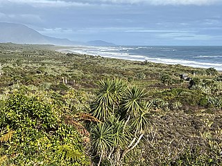
The Barrytown Flats are a 17 km (11 mi) coastal plain north of Greymouth on the West Coast of New Zealand's South Island. A series of postglacial shorelines and dunes backed by a former sea cliff, they was originally covered with wetland and lowland forest, including numerous nīkau palms. The sands were extensively sluiced and dredged for gold from the 1860s, centred on the small settlement of Barrytown. The drier areas of the flats have been converted into pasture, but significant areas of forest remain, including Nikau Scenic Reserve. The flats are bordered by Paparoa National Park and the only breeding site of the Westland petrel. There are significant deposits of ilmenite in the Barrytown sands, and there have been several mining proposals, but the possible environmental consequences have been contentious.

The Truman Track is a short, easy walking track located north of Punakaiki, in the coastal Paparoa National Park in the South Island of New Zealand. Although only 600 m (2,000 ft) long, it has been described as "one of the most delightful and interesting short walks on the West Coast". The track passes through lowland coastal forest of podocarps, rātā trees and nīkau palms, with dense understorey vegetation. It finishes at the coastline, where there is a viewing platform providing views along the coast, with surrounding cliffs, rock overhangs, and a waterfall that cascades directly onto the beach.
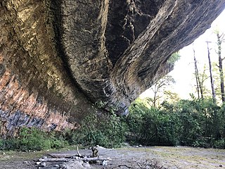
The Ballroom Overhang is a large limestone outcrop on the Fox River in Paparoa National Park, in the Buller District of New Zealand. The Ballroom Overhang provides a sheltered place for resting or overnight camping. The overhang is 10 m (33 ft) at its highest point, 100 m (330 ft) long, and 30 m (98 ft) at its widest point.

The Pancake Rocks and Blowholes are a coastal rock formation at Punakaiki on the West Coast of the South Island of New Zealand. They are a popular visitor attraction.
Bullock Creek or Punungairo is a river valley in the Paparoa National Park, located just north of Punakaiki on the West Coast of New Zealand. It includes a rare and nationally significant polje, a large, flat-floored depression within karst limestone. The Bullock Creek polje is New Zealand's only example of this type of landform.

The Inland Pack Track is a trail in the Paparoa National Park on West Coast of New Zealand. The full length of the trail commences at the Punakaiki River in the south, and ends at the mouth of the Fox River in the north. It takes two or three days to complete the track.

The Croesus Track is a 22.1 km (13.7 mi) historic miners trail to the south of Paparoa National Park in the Grey District of South Island of New Zealand. The route crosses the Paparoa Range from Blackball in the Grey Valley to Barrytown on the Tasman Sea coast. The first section, starting from the Blackball end, is shared with the Paparoa Track which follows the route of the Croesus Track to top of the Paparoa Range. This section is shared-use between hiking and mountain biking.

The Pike29 Memorial Track is a hiking track located near the Paparoa National Park in the Grey District of the South Island of New Zealand. The track was created as a memorial for the 29 miners who lost lives in the Pike River Mine disaster. The track is a branch of the Paparoa Track, the tenth Great Walk created. Both tracks were originally scheduled to open in 2018. The Pike29 Memorial Track opened in February 2024, four years after the Paparoa Track. The Pike River Mine portal features a memorial and interpretation centre.

The Waitakere / Nile River is a river on the West Coast of New Zealand's South Island. It rises in the Paparoa Range and flows through a limestone karst landscape in a roughly northwest direction for its entire length, reaching the Tasman Sea just north of Charleston. The river and its surrounds are a popular tourist destination, particularly for a bush train along the river's canyon and caving through the nearby Metro / Te Ananui Caves. The lower reaches of the river are also a popular fishing spot, particularly for brown trout.


