
Westport is a town in the West Coast region of the South Island of New Zealand. Established in 1861, it is the oldest European settlement on the West Coast. Originally named Buller, it is on the right bank and at the mouth of the Buller River, close by the prominent headland of Cape Foulwind. It is connected via State Highway 6 with Greymouth, 100 kilometres (62 mi) to the south, and with Nelson 222 kilometres (138 mi) in the northeast, via the Buller Gorge. The population of the Westport urban area was 4,250 as of June 2023. The Buller District had a population of 9,670.
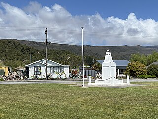
Waimangaroa is a small town located on the West Coast of New Zealand.

The NZR WB class was a class of tank locomotives that operated in New Zealand. Built in 1898 by the Baldwin Locomotive Works, the twelve members of the class entered service during the first five months of 1899. Eight were withdrawn by the end of 1935, while four others survived with new boilers until the mid-1950s.

The NZR C class tank locomotives operated on New Zealand's national rail network during its infancy. They are sometimes referred to as the little C class or the original C class to distinguish them from the C class of 1930.

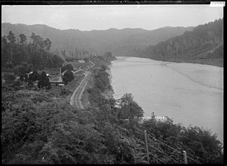
The Stillwater Ngākawau Line (SNL), formerly the Stillwater–Westport Line (SWL) and the Ngakawau Branch, is a secondary main line, part of New Zealand's national rail network. It runs between Stillwater and Ngakawau via Westport on the West Coast of the South Island. It was one of the longest construction projects in New Zealand's history, with its first section, at the south end, opened in 1889, and the beginnings of the Ngākawau Branch, at its Westport end, in 1875. The full line was completed in 1942. The only slower railway projects were Palmerston North to Gisborne, 1872 to 1942, and the Main North Line to Picton, 1872 to 1945.
Te Kuha is a small village located to the east of Westport in the Buller District of the West Coast region of New Zealand's South Island. It is located at the western end of the Lower Buller Gorge, with the Buller River flowing through the village.

The Seddonville Branch, later truncated as the Ngākawau Branch, is a branch line railway in the West Coast region of New Zealand's South Island. Construction began in 1874 and it reached its terminus at the Mokihinui Mine just beyond Seddonville in 1895. In 1981 it was closed past Ngākawau and effectively became an extension of the Stillwater–Westport Line, since formalised as the Stillwater–Ngākawau Line.

Seddonville is a lightly populated locality on the West Coast of New Zealand's South Island. It is most famous for the historical role it played in New Zealand's coal mining industry.
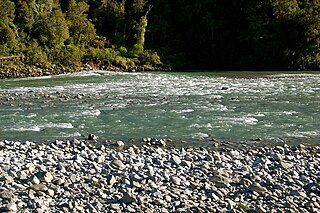
The Mōkihinui River is a river located on the West Coast of New Zealand's South Island, about 40 kilometres north of Westport. Meridian Energy had proposed the Mokihinui Hydro project on the river in 2007 but it was cancelled in May 2012. In 2019, it was announced that 64,400 ha of land in the Mōkihinui River catchment, including 15 km (9.3 mi) of river bed, would be added to Kahurangi National Park.
Summerlea is a lightly populated locality on the West Coast of New Zealand's South Island.

Hector and Ngakawau are two lightly populated settlements located at the mouth of the Ngākawau River in the West Coast region of New Zealand. Both settlements are situated on State Highway 67 between Westport and Karamea. Despite a low population, many of the workers at New Zealand's largest open-cut coal mine at Stockton choose to live at these places and shuttles frequently operate between the two places.
The Conns Creek Branch was a 2.7 kilometre branch line railway in the West Coast region of New Zealand's South Island. It diverged from the Seddonville Branch at Waimangaroa and followed the southern bank of the Waimangaroa River to the line's terminus at Conns Creek at the foot of the Denniston Incline. The line operated from 1877 until 1967 and existed for the sole purpose of conveying coal from mines to the port of Westport.
There have been various proposals to link the city of Nelson to New Zealand’s South Island rail network, but none have come to fruition.
State Highway 67 (SH 67) is a New Zealand state highway located in the northern parts of the South Island of New Zealand. It is 51.2 km long usually on the coast and connects SH 6 with the settlement of Mokihinui. It used to be 96 kilometres long and ran the entire length of the road from Westport to Karamea The highway and its spur serves the large West Coast town of Westport and lies entirely within the Buller District.

The Cape Foulwind Railway was a branch railway line west of Westport to Cape Foulwind. In 1886 the Westport Harbour Board built the line to their quarry to transport rocks to their breakwaters in the Buller River. In 1888 it was linked to Westport by a road-rail bridge over the Buller River. The iron bridge was planked with kauri forming a 12 ft (3.7 m) wide road. The bridge cost £13,794 and was 1,040 ft (320 m) long. By 1888 it was said to be carrying a considerable passenger traffic, using two coaches. In 1914 a new section of line including a tunnel was built to a new quarry south of the Cape.

Buller High School is a secondary school in the town of Westport, New Zealand. The school has a roll of over 360 students, all Year 9 to Year 13. As well as students from Westport, the school has a large number of students from nearby towns that do not have high schools of their own, such as Waimangaroa, Granity, and Seddonville. The school was founded in 1922, although has ties to earlier secondary schooling in the Buller district.
Mokihinui is a lightly populated locality on the West Coast of New Zealand's South Island.
The Koranui Incline was an inclined tramway on the West Coast of the South Island of New Zealand that, for four years from late 1882 to the end of 1886, brought coal from a mine high on Mt Frederick down to a railway line near sea level.
The Rockies Incline was an inclined tramway on the West Coast of the South Island of New Zealand that for ten years from 1925 to 1935 brought coal from the Westport Main Coal Company’s mine on the Millerton-Stockton plateau down to the Westport to Seddonville railway line near sea level.

The Charming Creek Tramway was a 9 kilometres (5.6 mi) long private bush tramway at Ngakawau in Buller District on the West Coast in New Zealand. It was used from 1903 or 1905 to 1958.
