Abel Janszoon Tasman was a Dutch seafarer and explorer, best known for his voyages of 1642 and 1644 in the service of the Dutch East India Company (VOC).

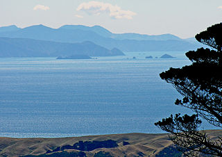
Arapaoa Island is the second-largest island in the Marlborough Sounds, at the north-east tip of the South Island of New Zealand. The island has a land area of 75 km2. Queen Charlotte Sound defines its western side, while to the south lies Tory Channel, which is on the sea route between Wellington in the North Island to Picton. Cook Strait's narrowest point is between Arapaoa Island's Perano Head and Cape Terawhiti in the North Island.

The North Island, also officially named Te Ika-a-Māui, is one of the two main islands of New Zealand, separated from the larger but less populous South Island by Cook Strait. With an area of 113,729 km2 (43,911 sq mi), it is the world's 14th-largest island, constituting 43% of New Zealand's land area. It has a population of 3,997,300, which is 77% of New Zealand's residents, making it the most populous island in Polynesia and the 28th-most-populous island in the world.

Bass Strait is a strait separating the island state of Tasmania from the Australian mainland. The strait provides the most direct waterway between the Great Australian Bight and the Tasman Sea, and is also the only maritime route into the economically prominent Port Phillip Bay.

The Tasman Sea is a marginal sea of the South Pacific Ocean, situated between Australia and New Zealand. It measures about 2,000 km (1,200 mi) across and about 2,800 km (1,700 mi) from north to south. The sea was named after the Dutch explorer Abel Janszoon Tasman, who in 1642 was the first known person to cross it. British explorer Lieutenant James Cook later extensively navigated the Tasman Sea in the 1770s during his three voyages of exploration.
Cook Strait is a strait that separates the North and South Islands of New Zealand. The strait connects the Tasman Sea on the northwest with the South Pacific Ocean on the southeast. It is 22 kilometres (14 mi) wide at its narrowest point, and is considered one of the most dangerous and unpredictable waters in the world. Regular ferry services run across the strait between Picton in the Marlborough Sounds and Wellington.

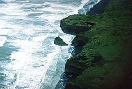
Taranaki is a region in the west of New Zealand's North Island. It is named after its main geographical feature, the stratovolcano Mount Taranaki, also known as Mount Egmont.

The Great Australian Bight is a large oceanic bight, or open bay, off the central and western portions of the southern coastline of mainland Australia.

The southern right whale is a baleen whale, one of three species classified as right whales belonging to the genus Eubalaena. Southern right whales inhabit oceans south of the Equator, between the latitudes of 20° and 60° south. In 2009 the global population was estimated to be approximately 13,600.
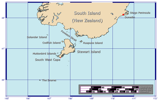
Foveaux Strait is a strait that separates Stewart Island from the South Island of New Zealand. The width of the strait ranges from about 23 to 53 km and the depth varies between 18 and 46 m. Captain James Cook passed around the southern tip of Stewart Island during his circumnavigation of the South Island in 1770 but did not record the presence of a seaway between Stewart Island and the mainland. The strait was not properly recorded until 1804 when an American sealer Owen Folger Smith made a chart.
Kahurangi Point is a headland on the West Coast of New Zealand's South Island, overlooking the Tasman Sea. It is located in Kahurangi National Park between Karamea and Farewell Spit.

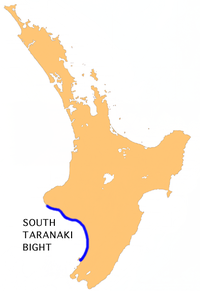
The Pātea River is in Taranaki in the North Island of New Zealand. It runs for 105 kilometres from the eastern slopes of Mount Taranaki, passing east through Stratford before swinging south and reaching the South Taranaki Bight near the town of Patea.

The following outline is provided as an overview of and introduction to Oceanography.
The Manawapou River is a river of the Taranaki Region of New Zealand's North Island. It flows southwest, from its origins in rough hill country to the northeast of Hāwera, to reach the South Taranaki Bight between Hāwera and Patea.

The Tangahoe River is a river of the Taranaki Region of New Zealand's North Island. It flows generally southwest from its origins in hill country to the east of Lake Rotorangi, reaching the Tasman Sea in the South Taranaki Bight 5 km (3.1 mi) southeast of Hawera.

Golden Bay is a large shallow bay in New Zealand's Tasman District, near the northern tip of the South Island. An arm of the Tasman Sea, the bay lies northwest of Tasman Bay and Cook Strait. It is protected in the north by Farewell Spit, a 26 km long arm of fine golden sand that is the country's longest sandspit. The Aorere and Tākaka rivers are the major waterways to flow into the bay from the south and the west.

Whale watching in New Zealand is predominantly centred around the areas of Kaikōura and the Hauraki Gulf. Known as the 'whale capital', Kaikōura is a world-famous whale watching site, in particular for sperm whales which is currently the most abundant of large whales in New Zealand waters. The Hauraki Gulf Marine Park is also a significant whale watching area with a resident population of Bryde's Whales commonly viewed alongside other cetaceans Common Dolphins, Bottlenose Dolphins and Orca. Whale watching is also offered in other locations, often as eco-tours and in conjunction with dolphin watching. Land-based whale watching from New Zealand's last whaling station, which closed in 1964, is undertaken for scientific purposes, mostly by ex-whalers.

Hikurangi Marine Reserve is a marine reserve off the coast of the Kaikōura District, in the Canterbury Region of New Zealand's South Island. It is the largest and deepest marine reserve in New Zealand.
The North Island, also officially named Te Ika-a-Māui, is one of the two main islands of New Zealand, separated from the larger but much less populous South Island by the Cook Strait. The island's area is 113,729 square kilometres (43,911 sq mi), making it the world's 14th-largest island. It has a population of 3,997,300, accounting for approximately 77% of the total residents of New Zealand.
Trans-Tasman Resources (TTR) is an Australian mining company, wholly owned since 2023 by another Australian mining company Manuka Resources. TTR has been involved in court proceedings in New Zealand related to proposed seabed mining off the Taranaki coast.