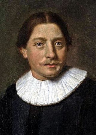
Abel Janszoon Tasman was a Dutch seafarer and explorer, best known for his voyages of 1642 and 1644 in the service of the Dutch East India Company (VOC).

Aoraki / Mount Cook is the highest mountain in New Zealand. Its height, as of 2014, is listed as 3,724 metres. It sits in the Southern Alps, the mountain range that runs the length of the South Island. A popular tourist destination, it is also a favourite challenge for mountain climbers. Aoraki / Mount Cook consists of three summits: from south to north, the Low Peak, the Middle Peak and the High Peak. The summits lie slightly south and east of the main divide of the Southern Alps, with the Tasman Glacier to the east and the Hooker Glacier to the southwest. Mount Cook is ranked 10th in the world by topographic isolation.

The North Island, also officially named Te Ika-a-Māui, is one of the two main islands of New Zealand, separated from the larger but less populous South Island by Cook Strait. With an area of 113,729 km2 (43,911 sq mi), it is the world's 14th-largest island, constituting 44% of New Zealand's land area. It has a population of 3,997,300, which is 77% of New Zealand's residents, making it the most populous island in Polynesia and the 28th-most-populous island in the world.
Taranaki is a region in the west of New Zealand's North Island. It is named after its main geographical feature, the stratovolcano Mount Taranaki, also known as Mount Egmont.

Aoraki / Mount Cook National Park is a national park located in the central-west of the South Island of New Zealand. It was established in October 1953 and takes its name from the highest mountain in New Zealand, Aoraki / Mount Cook. The area of the park is 707 km2 (273 sq mi), and it shares a border with Westland Tai Poutini National Park along the Main Divide of the Southern Alps. The national park consists of reserves that were established as early as 1885 to protect the area's significant landscape and vegetation. Glaciers cover 40% of the park, including the county's largest glacier, Haupapa / Tasman Glacier. In 1990, the park was included in the area designated as the Te Wāhipounamu World Heritage Site. The park is managed by the Department of Conservation (DOC) alongside Ngāi Tahu, the iwi who are mana whenua in the region.

Egmont National Park is located south of New Plymouth, close to the west coast of the North Island of New Zealand. The park covers three volcanic cones: Mount Taranaki and its slopes, Pouakai and Kaitake. The park was first created in 1881 as a forest reserve and went on to become New Zealand’s second national park, preceded by Tongariro National Park, in 1900.

Mount Taranaki is a dormant stratovolcano in the Taranaki region on the west coast of New Zealand's North Island. At 2,518 metres (8,261 ft), it is the second highest mountain in the North Island, after Mount Ruapehu. It has a secondary cone, Fanthams Peak, 1,966 metres (6,450 ft), on its south side.
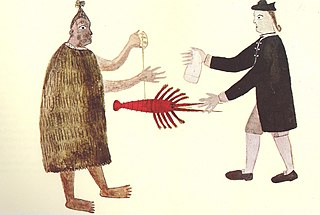
Marc-Joseph Marion du Fresne was a French privateer, East India captain and explorer. The expedition he led to find the hypothetical Terra Australis in 1771 made important geographic discoveries in the south Indian Ocean and anthropological discoveries in Tasmania and New Zealand. In New Zealand they spent longer living on shore than any previous European expedition. Half way through the expedition's stay Marion died during a military assault by the Ngare Raumati iwi.
This is a timeline of the history of New Zealand that includes only events deemed to be of principal importance – for less important events click the year heading or refer to List of years in New Zealand.
Ngāti Toa, Ngāti Toarangatira or Ngāti Toa Rangatira, is a Māori iwi (tribe) based in the southern North Island and in the northern South Island of New Zealand. Its rohe extends from Whanganui in the north, Palmerston North in the east, and Kaikōura and Hokitika in the south. Ngāti Toa remains a small iwi with a population of only about 9000. It has four marae: Takapūwāhia and Hongoeka in Porirua City, and Whakatū and Wairau in the north of the South Island. Ngāti Toa's governing body has the name Te Rūnanga o Toa Rangatira.

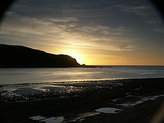
The South Taranaki Bight is a large bay on the west coast of New Zealand, south of Taranaki, west of the Manawatu, north and west of the western entrance of Cook Strait and north of the South Island. The name is sometimes used for a much smaller bay in South Taranaki, between the mouth of the Kaupokonui Stream directly south of Mount Taranaki and the mouth of the Pātea River.

The Whanganui River is a major river in the North Island of New Zealand. It is the country's third-longest river, and has special status owing to its importance to the region's Māori people. In March 2017 it became the world's second natural resource to be given its own legal identity, with the rights, duties and liabilities of a legal person. The Whanganui Treaty settlement brought the longest-running litigation in New Zealand history to an end.

Most New Zealand place names have a Māori or a British origin. Both groups used names to commemorate notable people, events, places from their homeland, and their ships, or to describe the surrounding area. It is unknown whether Māori had a name for the whole of New Zealand before the arrival of Europeans, but post-colonisation the name Aotearoa has been used to refer to the whole country. Dutch cartographers named the islands Nova Zeelandia, the Latin translation of the Dutch Nieuw Zeeland. By the time of British exploration, the country's name was anglicised to New Zealand.

The source of the Waitara River lies in the very steep hill country to the east of Mount Taranaki/Egmont, near Tahora. After proceeding in a southwesterly direction toward Central Taranaki, the river abruptly turns to flow in a northwesterly direction to the Tasman Sea: meeting it at the coastal town of Waitara.
The first humans are thought to have arrived in New Zealand from Polynesia some time around 1300 AD. The people, who later became known as Māori, eventually travelled to almost every part of the country. Their arrival had a significant impact on the local fauna, particularly the flightless birds such as moa.
The history of the Nelson Region of New Zealand dates back to settlement by the Māori people in about the 12th century. The Nelson and Marlborough Region were known to the Māori as Te Tau Ihu o Te Waka a Maui which means "The Prow of the Canoe of Maui".
This timeline sets out intertribal battles involving Māori people in what is now New Zealand.

Netherlands – New Zealand relations is the official relationship between the Kingdom of the Netherlands and New Zealand. New Zealand has an embassy in The Hague and the Netherlands has an embassy in Wellington. The Ambassador to the Netherlands is concurrently accredited to Denmark, Finland, Iceland and Norway.

