Waitotara School

Last updated

Waitotara School
Address
Trent Street,
Waitotara,
New Zealand
Coordinates 39°48′15″S174°44′06″E / 39.8042°S 174.7351°E / -39.8042; 174.7351 Coordinates: 39°48′15″S174°44′06″E / 39.8042°S 174.7351°E / -39.8042; 174.7351
Information
TypeState, Primary (Year 0-8)
Established1874
Ministry of Education Institution no. 2474
PrincipalRoss Harvey
School roll22
Socio-economic decile2 [1]
Website

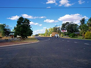
Waitotara School is a small state primary school situated in the rural village of Waitotara, located between Wanganui and Hawera, New Zealand on State Highway 3.

Waitotara Place in Taranaki, New Zealand

Waitotara is a town in South Taranaki, New Zealand. Waverley is 10 km to the north-west, and Wanganui is 34 km to the south-east. State Highway 3 passes through it. The Waitotara River flows past the east side of the town.

Hawera Place in Taranaki, New Zealand

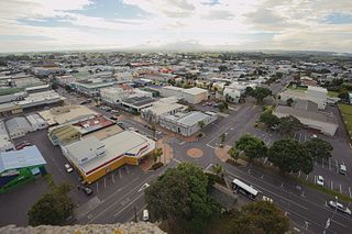
Hawera is the second-largest centre in the Taranaki region of New Zealand's North Island, with a population of 12,150. It is near the coast of the South Taranaki Bight. The origins of the town lie in a government military base that was established in 1866, and the town of Hawera grew up around a blockhouse in the early 1870s.

New Zealand Country in Oceania

New Zealand is a sovereign island country in the southwestern Pacific Ocean. The country geographically comprises two main landmasses—the North Island, and the South Island —and around 600 smaller islands. New Zealand is situated some 2,000 kilometres (1,200 mi) east of Australia across the Tasman Sea and roughly 1,000 kilometres (600 mi) south of the Pacific island areas of New Caledonia, Fiji, and Tonga. Because of its remoteness, it was one of the last lands to be settled by humans. During its long period of isolation, New Zealand developed a distinct biodiversity of animal, fungal, and plant life. The country's varied topography and its sharp mountain peaks, such as the Southern Alps, owe much to the tectonic uplift of land and volcanic eruptions. New Zealand's capital city is Wellington, while its most populous city is Auckland.

The school sits on the banks of the Waitotara River, 47 km south of Ngamatapouri, and was fully refurbished after devastating floods in 2004. These floods destroyed much of the interior of the school buildings as well as furniture and equipment, while many homes in the small community of Waitotara were also badly damaged.

The Waitotara River in New Zealand's North Island stretches approximately 100 km in length from its headwaters in the Matemateaonga Ranges to its mouth on the South Taranaki Bight. The river takes in significant tributaries such as the Ngutuwera, Makakaho, Pokeka, Omaru and Totara Streams.

Ngamatapouri Place in Taranaki, New Zealand

Ngamatapouri is a small rural locality in the Waitotara River valley, 47 km north of Waitotara village, in south Taranaki, New Zealand. Wanganui is about 80 km to the southeast. The road is sealed as far as the school.

Notes


Related Research Articles

Flood Overflow of water that submerges land that is not normally submerged

A flood is an overflow of water that submerges land that is usually dry. In the sense of "flowing water", the word may also be applied to the inflow of the tide. Floods are an area of study of the discipline hydrology and are of significant concern in agriculture, civil engineering and public health.

Prescott, Arizona City in Arizona, United States

Prescott is a city in Yavapai County, Arizona, United States. According to the 2010 Census, the population of the city is 39,843. The city is the county seat of Yavapai County. In 1864 Prescott was designated as the capital of the Arizona Territory, replacing the temporary capital at Fort Whipple. The Territorial Capital was moved to Tucson in 1867. Prescott again became the Territorial Capital in 1877, until Phoenix became the capital in 1889.

Ottawa, Kansas City and County seat in Kansas, United States

Ottawa is a city in, and the county seat of, Franklin County, Kansas, United States. It is located on both banks of the Marais des Cygnes River near the center of Franklin County. As of the 2010 census, the city population was 12,649.

Corning (city), New York City in New York State in the United States

Corning is a city in Steuben County, New York, United States, on the Chemung River. The population was 11,183 at the 2010 census. It is named for Erastus Corning, an Albany financier and railroad executive who was an investor in the company that developed the community. The city is best known as the headquarters of Fortune 500 company Corning Incorporated, formerly Corning Glass Works, a manufacturer of glass and ceramic products for industrial, scientific and technical uses.

Lismore, New South Wales Town in New South Wales, Australia

Lismore is a city in northeastern New South Wales, Australia and the main population centre in the City of Lismore local government area; it is also a regional centre in the Northern Rivers region of the State. According to the 2016 Australian Census, the population in the Lismore urban centre was 27,569.

Emerald, Queensland Town in Queensland, Australia

Emerald is a town in the Central Highlands Region, Queensland, Australia. At the 2016 Census, Emerald had an urban population of approximately 13,500. The town is the business centre for the Central Highlands Regional Council.

Venn Spearman Young was a New Zealand politician. He was a member of the National Party, and served as a Cabinet Minister in the government of Robert Muldoon. He is known for his failed attempt to legalise "homosexual acts" in 1975.

Waverley, Taranaki Place in Taranaki, New Zealand

Waverley is a town located in the South Taranaki District in New Zealand. It is 44 km northwest of Wanganui. Patea is 17 km to the west, and Waitotara is 10 km to the southeast. State Highway 3 and the Marton - New Plymouth Line railway run through the town.

Dan Flood American politician

Daniel John Flood was an American attorney and politician, a flamboyant and long-serving Democratic United States Representative from Pennsylvania. First elected to the US House in 1944, he served continuously from 1955 to 1980. Flood was credited with leading the effort to help the Wilkes-Barre area recover after the 1972 effects of the Agnes Flood.

Paya Jaras is a state constituency in Malaysia, providing a seat in the Selangor State Assembly. It has a population of nearly 70,000. The population comprises 60% Malays, 30% Chinese and 10% Indians. Paya Jaras is part of the Subang parliamentary constituency.

Condamine, Queensland Town in Queensland, Australia

Condamine is a town and a locality in the Western Downs Region, Queensland, Australia. At the 2016 census, Condamine had a population of 384.

Midhirst Place in Taranaki, New Zealand

Midhirst is a small village in Taranaki, New Zealand, approximately 4 km north of Stratford, on State Highway 3. Inglewood is 17 km (11 mi) north of Midhirst, and New Plymouth is 35 km (22 mi) to the northwest.

The 2007 Bihar flood, which started in August 2007, was described by the United Nations as the worst flood in the "living memory" of Bihar. It is believed to be the worst flood in Bihar in the last 30 years. By 3 August, the estimated death toll was 41 people, and 48 schoolgirls were marooned in a school in the Darbhanga district. By 8 August, the flooding had affected an estimated 10 million people in Bihar. Army helicopters delivered food packets to Bihar residents and 180 relief camps were established. By 10 August, aid workers in Bihar reported that there was a dramatic increase of people with diarrhoea and by 11 August, flood deaths were still occurring. Total deaths recorded in 2007 Bihar floods was 1,287, which was second highest death toll in state after 1,399 deaths in 1987 Bihar floods.

Waitotara was a New Zealand parliamentary electorate in South Taranaki. It existed from 1881 to 1893, and again from 1978 to 1996. It was represented by four Members of Parliament.

Whanganui District Territorial authority in Manawatu-Wanganui Region, New Zealand

Whanganui District is one of the districts of New Zealand. It includes the city of Whanganui and surrounding areas.

Harlin Town in Queensland, Australia

Harlin is a small town in south east Queensland, Australia. The town is on the Brisbane Valley Highway and the Brisbane River, 131 kilometres (81 mi) north west of the state capital, Brisbane. At the 2011 census, Harlin and the surrounding area had a population of 534.

Kai Iwi Place in Manawatu-Wanganui, New Zealand

Kai Iwi is a rural community west of Whanganui in New Zealand's North Island. It lies close to SH 3, approximately half way between Whanganui and Waitotara.