
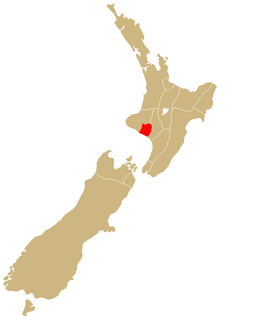
Stratford is the only town in Stratford District, and the seat of the Taranaki region, in New Zealand's North Island. It lies beneath the eastern slopes of Mount Taranaki/Egmont, approximately halfway between New Plymouth and Hāwera, near the geographic centre of the Taranaki Region. The town has a population of 6,120, making it the 62nd largest urban area in New Zealand, and the fourth largest in Taranaki.

Patea is the third-largest town in South Taranaki District, New Zealand. It is on the western bank of the Pātea River, 61 kilometres north-west of Whanganui on State Highway 3. Hāwera is 27 km to the north-west, and Waverley 17 km to the east. The Pātea River flows through the town from the north-east and into the South Taranaki Bight.

Ngāti Porou is a Māori iwi traditionally located in the East Cape and Gisborne regions of the North Island of New Zealand. Ngāti Porou is affiliated with the 28th Maori Battalion and has the second-largest affiliation of any iwi in New Zealand, with 71,910 registered members in 2006. The traditional rohe or tribal area of Ngāti Porou extends from Pōtikirua and Lottin Point in the north to Te Toka-a-Taiau in the south.
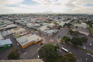
Hāwera is the second-largest centre in the Taranaki region of New Zealand's North Island, with a population of 10,150. It is near the coast of the South Taranaki Bight. The origins of the town lie in a government military base that was established in 1866, and the town of Hāwera grew up around a blockhouse in the early 1870s.

Ngāi Te Rangi or Ngāiterangi is a Māori iwi, based in Tauranga, New Zealand. Its rohe extends to Mayor Island / Tuhua and Bowentown in the north, to the Kaimai Range in the west, south of Te Puke and to Maketu in the east.

Manaia is a rural town in South Taranaki District, New Zealand. Ōpunake is 29 km to the northwest, and Hāwera is 13 km to the southeast. Kaponga is 15 km north. State Highway 45 passes through the town. Manaia is named after the former Māori chief of the district, Hukunui Manaia.
Rongorongo is an ancestress from Ra'iātea Island (Hawaiki) in Māori tradition, particularly of the Ngā Rauru, Ngāti Ruanui, Taranaki, and Whanganui iwi. She was the wife of Turi, the chief of the Aotea canoe which was given to Rongorongo as a present by her father Toto. After Rongorongo overheard Uenuku chanting incantations of Turi's murder, Turi and his people fled to New Zealand in the Aotea and arrived at the mouth of the Patea River.
Te Teko is a small inland town along the banks of the Rangitaiki River in the Bay of Plenty region of New Zealand's North Island.

Ngāti Ruanui is a Māori iwi traditionally based in the Taranaki region of New Zealand. In the 2006 census, 7,035 people claimed affiliation to the iwi. However, most members now live outside the traditional areas of the iwi.
Ngā Rauru is a Māori iwi in the South Taranaki region of New Zealand. In the 2006 census, 4,047 Māori claimed affiliation to Ngā Rauru, representing 12 hapu.
Urenui is a settlement in northern Taranaki, in the North Island of New Zealand. It is located on State Highway 3 close to the shore of the North Taranaki Bight, 13 kilometres east of Waitara and 6 km south-west of Mimi. The Urenui River flows past the settlement into the North Taranaki Bight.

Whangape Harbour is a harbour on the west coast of Northland, New Zealand. There is a settlement called Whangape on the northern side of the harbour. Another, called Pawarenga, is located on the southern side. Kaitaia is 42 km north east.
In Māori tradition, Te Kōhatuwhenua was one of the great ocean-going, voyaging canoes that was used in the migrations that settled New Zealand. Taranaki iwi Ngāti Ruanui and Ngā Rauru trace their ancestry back to Taikehu, the captain of Te Kōhatuwhenua.

Kakaramea is a town in South Taranaki, New Zealand. State Highway 3 passes through it. Patea is about 6 km to the south-east, and Hāwera is about 20 km to the north-west.
Ohangai is a locality in South Taranaki, New Zealand. It is approximately 10 km east of Hawera and 6 km north of Mokoia
Waitōtara is a town in South Taranaki, New Zealand. Waverley is 10 km to the north-west, and Whanganui is 34 km to the south-east. State Highway 3 passes through it. The Waitōtara River flows past the east side of the town.

Tikitiki is a small town in Waiapu Valley on the north bank of the Waiapu River in the Gisborne Region of the North Island of New Zealand. The area in which the town resides was formerly known as Kahukura. By road, Tikitiki is 145 km (90 mi) north-northeast of Gisborne, 20 km (12 mi) northeast by north of Ruatoria, and 24 km (15 mi) south by east of Te Araroa. The name of the town comes from the full name of Māui, Māui-tikitiki-a-Taranga. State Highway 35 passes through the town at the easternmost point of the New Zealand state highway network.

Kaiwhaiki is a settlement 18 kilometres (11 mi) upriver from Whanganui, New Zealand.
Hauāuru Māori are a group of Māori iwi at or around the west coast of the North Island of New Zealand. It includes the iwi (tribe) of Te Āti Haunui-a-Pāpārangi and its affiliated iwi of Ngāti Hau. It also includes the iwi of Ngāti Tama, Ngāti Mutunga, Te Āti Awa, Taranaki, Ngāti Maru, Ngāruahine, Ngāti Ruanui, Ngā Rauru, Te Korowai o Wainuiārua, Ngāti Rangi, Ngāti Apa and Ngāti Hauiti.
Rotoiti is a settlement on the shore of Lake Rotoiti, in Rotorua Lakes within the Bay of Plenty Region of New Zealand's North Island.

