Rakiura National Park

Last updated

Rakiura National Park
Stewart Island 28.jpg
New Zealand (relief map).png
Disc Plain red.svg
Location of Rakiura National Park in New Zealand
Location Stewart Island / Rakiura, New Zealand
Nearest town Oban
Coordinates 46°54′S168°7′E / 46.900°S 168.117°E / -46.900; 168.117
Area1,399.6 km2 (540.4 sq mi)
Established2002
Governing body Department of Conservation
Official website

Rakiura National Park is a nature reserve park located on Stewart Island / Rakiura, New Zealand. It is the newest national park of New Zealand and opened in 2002. The protected area covers about 85% of the island.

Contents

History

Park establishment

Robert Beck's Chain Sculpture, at the entrance to Rakiura National Park Stewart Island 27.jpg
Robert Beck's Chain Sculpture, at the entrance to Rakiura National Park

Rakiura National Park is the 14th of New Zealand's national parks and was officially opened on 9 March 2002 by the Prime Minister, Helen Clark, the Minister of Conservation, Sandra Lee, and the mountaineer Sir Edmund Hillary. [1] It is New Zealand's newest national park. [2]

Geography

Rakiura National Park covers close to 1,400 square kilometres (540 sq mi), [3] which is about 85% of Stewart Island / Rakiura, New Zealand's third-largest island. The park area excludes the township area around Halfmoon Bay (Oban) and some roads as well as private or Māori-owned land further inland. [1] It is made up of a network of former nature reserves, scenic reserves, and State Forest areas. A chain sculpture at the entrance to Rakiura National Park symbolises the Māori mythology of the island, which held that the South Island was the canoe of the demigod Māui and that Rakiura was the canoe's anchor, as evidenced by an alternative name for the island of "Te Punga o Te Waka a Māui" (the anchor of Māui's canoe). [4] The sculpture was designed by noted Southland sculptor Russell Beck, and was unveiled as part of the opening of the national park. [5] [1] In 2008, a similar sculpture was erected in Bluff, and it represents the other end of the chain. [6]

Ecology

Near Port William Hut, North Coast Stewart Island Rakiura Track.jpg
Near Port William Hut, North Coast

Fauna

Many native birds can be found within the park, and Rakiura offers perhaps the best opportunity anywhere in New Zealand for viewing kiwi in the wild. This is in part due to the absence of stoats and ferrets. Home to the Southern brown kiwi or Tokoeka, this is the largest of the kiwi species. There are thought to be around 15,000 kiwi on Stewart Island / Rakiura. [7]

Certain coastal areas of this park are breeding areas for the endangered yellow-eyed penguin. [8] Weka, a flightless and curious bird species, can only be found on offshore islands. [9] The South Island kākā can commonly be seen near the town of Halfmoon Bay and Ulva Island. [10]

In the 1970s, kākāpō were found in the Tin Range at a time when it was thought that the species was nearly extinct. The kākāpō have been transferred to nearby Codfish Island / Whenua Hou, which is not part of the national park. [11]

Tramping

Rakiura Track

Rakiura National Park, Stewart Island Stewart Island 29.jpg
Rakiura National Park, Stewart Island

The popular Rakiura Track is within the national park. The track typically takes three days and two nights to complete, the track is 32 kilometres (20 mi) long. The track meanders through lowland kāmahi, tōtara and rimu forest. The track takes in Port William and the north arm of Paterson Inlet. [12] [13] Rakiura kiwi is often seen at night time near the huts. [14] [15] [16]

Northwest Circuit

The Northwest Circuit circumnavigates the northern and western aspects of Stewart Island. The track is 125 kilometres (78 mi) long and takes most people between eight and ten days to complete. Most of the track is along the coastline visiting a series of very isolated sandy beaches. Once it reaches Mason Bay, the track crosses the Freshwater Depression before reaching Paterson Inlet. There are ten huts on the track which are, in general, spaced between five and seven hours walk apart. [12]

Southern Circuit

The Southern Circuit is a challenging nine-day tramping trip. It is 70 kilometres (43 mi) long, and after rain can involve long periods of walking in mud and deep water. [12] The Southern Circuit takes in Doughboy Bay Hut. This eight-bed hut is the southernmost hut in the Department of Conservation's network. [14]

See also

Related Research Articles

<span class="mw-page-title-main">Geography of New Zealand</span>

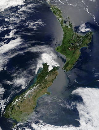
New Zealand is an island country located in the southwestern Pacific Ocean, near the centre of the water hemisphere. It consists of a large number of islands, estimated around 700, mainly remnants of a larger landmass now beneath the sea. The land masses by size are the South Island and the North Island, separated by the Cook Strait. The third-largest is Stewart Island / Rakiura, located 30 kilometres off the tip of the South Island across Foveaux Strait. Other islands are significantly smaller in area. The three largest islands stretch 1,600 kilometres across latitudes 35° to 47° south. New Zealand is the sixth-largest island country in the world, with a land size of 268,710 km2 (103,750 sq mi).

<span class="mw-page-title-main">National parks of New Zealand</span> Wikimedia list

The national parks of New Zealand are protected natural areas administered by the Department of Conservation (DOC). The first national parks established in the country were all focused on mountain scenery. Since the 1980s the focus has been on developing a more diverse representation of New Zealand landscapes. The parks are all culturally significant and many also contain historic features. Tongariro National Park is one of the World Heritage Sites that are of both cultural and natural significance, while four of the South Island national parks form Te Wahipounamu, another World Heritage Site. There are currently 13 national parks; a 14th, Te Urewera National Park, was disestablished in 2014.

<span class="mw-page-title-main">Kākāpō</span> Large endangered flightless nocturnal parrot endemic to New Zealand

The kākāpō, sometimes known as the owl parrot or moss chicken, is a species of large, nocturnal, ground-dwelling parrot of the superfamily Strigopoidea. It is endemic to New Zealand.

<span class="mw-page-title-main">Fiordland</span> Geographical region of New Zealand

Fiordland is a geographical region of New Zealand in the south-western corner of the South Island, comprising the westernmost third of Southland. Most of Fiordland is dominated by the steep sides of the snow-capped Southern Alps, deep lakes, and its steep, glacier-carved and now ocean-flooded western valleys. The name "Fiordland" comes from a variant spelling of the Scandinavian word for this type of steep valley, "fjord". The area of Fiordland is dominated by, and very roughly coterminous with, Fiordland National Park, New Zealand's largest National Park.

<span class="mw-page-title-main">Fiordland National Park</span> National park on South Island of New Zealand

Fiordland National Park is a national park in the south-west corner of South Island of New Zealand. It is the largest of the 13 national parks in New Zealand, with an area covering 12,607 km2 (4,868 sq mi), and a major part of the Te Wāhipounamu a UNESCO World Heritage Site established in 1990. The park is administered by the Department of Conservation. The southern ranges of the Southern Alps cover most of Fiordland National Park, combined with the deep glacier-carved valleys.

<span class="mw-page-title-main">Oban, New Zealand</span> Town in Stewart Island, New Zealand

Oban is the principal settlement on Stewart Island / Rakiura, the southernmost inhabited island of the New Zealand archipelago. Oban is located on Halfmoon Bay, on Paterson Inlet. It has aircraft connections with Invercargill and a ferry service to Bluff.

<span class="mw-page-title-main">Nelson Lakes National Park</span> National park in New Zealand

Nelson Lakes National Park is in the South Island of New Zealand, at the northern end of the Southern Alps. It was created in 1956. The park contains beech forests, multiple lakes, snow-covered mountains and valleys created by glaciers during the ice ages.

<span class="mw-page-title-main">Kahurangi National Park</span> National park in New Zealand

Kahurangi National Park in the northwest of the South Island of New Zealand is the second largest of the thirteen national parks of New Zealand. It was gazetted in 1996 and covers 5,193 km2 (2,005 sq mi), ranging from the Buller River near Murchison in the south, to the base of Farewell Spit in Golden Bay in the north. The park has no single dominant landform, but includes an unusually wide variety of landscapes, including mountain ranges, rivers, gorges, raised peneplains and karst features such as caves and arches. Many of the landforms within the park are considered to be nationally or internationally significant.

<span class="mw-page-title-main">Ulva Island (New Zealand)</span> Island in New Zealand

Ulva Island is a small island about 3.5 km (2.17 mi) long lying within Paterson Inlet, which is part of Stewart Island/Rakiura in New Zealand. It has an area of 267 hectares, of which almost all (261 ha) is part of Rakiura National Park. It was named after the island of Ulva in the Inner Hebrides of Scotland and was formerly called Coopers Island.

<span class="mw-page-title-main">Codfish Island / Whenua Hou</span> Island of New Zealand

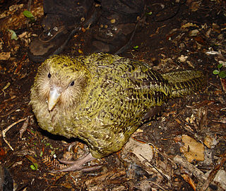
Codfish Island / Whenua Hou is a small island located to the west of Stewart Island in southern New Zealand. It reaches a height of 250 m (820 ft) close to the south coast. The island is home to Sirocco, an internationally famous kākāpō, a rare species of parrot.

<span class="mw-page-title-main">Rakiura Track</span> Hiking trail in New Zealand

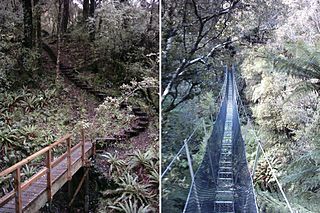
The Rakiura Track is a 32-kilometre (20 mi) circular tramping track in Rakiura National Park on Stewart Island in New Zealand. It is one of the New Zealand Great Walks. Hikers often take three days to walk it, but it can be done in one or two days.

<span class="mw-page-title-main">Mount Hikurangi (Gisborne District)</span> Mountain in New Zealand

Mount Hikurangi is a 1,752 m (5,748 ft) peak in the eastern corner of New Zealand's North Island, about 80 kilometres (50 mi) north of Gisborne, and 50 kilometres (31 mi) southwest of the East Cape Lighthouse. On a spur of the Raukumara Range in the Waiapu Valley, it is the North Island's highest non-volcanic peak.

<span class="mw-page-title-main">New Zealand Great Walks</span> Set of tramping tracks

The New Zealand Great Walks are a set of popular tramping tracks developed and maintained by the Department of Conservation. They are New Zealand's premier tracks, through areas of some of the best scenery in the country, ranging from coastlines with beaches to dense rain forests and alpine terrain. The tracks are maintained to a high standard, making it easier for visitors to explore some of the most scenic parts of New Zealand's backcountry.

Chalky Island or Te Kākahu-o-Tamatea is an island in the southwest of New Zealand, and is part of Fiordland National Park. It lies at the entrance to Taiari / Chalky Inlet, next to Rakituma / Preservation Inlet, at the southwestern tip of the South Island, 10 kilometres (6 mi) northwest of Puysegur Point, 15 kilometres (9 mi) southeast of West Cape, and 140 kilometres (87 mi) west of Invercargill.

<span class="mw-page-title-main">Birds of New Zealand</span>

The birds of New Zealand evolved into an avifauna that included many endemic species found in no other country. As an island archipelago, New Zealand accumulated bird diversity, and when Captain James Cook arrived in the 1770s he noted that the bird song was deafening.

<span class="mw-page-title-main">Stewart Island</span> New Zealands third largest island

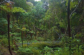
Stewart Island is New Zealand's third-largest island, located 30 kilometres south of the South Island, across the Foveaux Strait. It is a roughly triangular island with a total land area of 1,746 km2 (674 sq mi). Its 164-kilometre (102 mi) coastline is deeply creased by Paterson Inlet (east), Port Pegasus (south), and Mason Bay (west). The island is generally hilly and densely forested. Flightless birds, including penguins, thrive because there are few introduced predators. Almost all the island is owned by the New Zealand government, and over 80 per cent of the island is set aside as the Rakiura National Park.

<span class="mw-page-title-main">Haast tokoeka</span> Species of kiwi

The Haast tokoeka or Haast kiwi is a putative subspecies of the southern brown kiwi. It is one of the rarest kiwi in New Zealand. Like other kiwi, this bird is flightless.

<span class="mw-page-title-main">Ulva Island-Te Wharawhara Marine Reserve</span>

Ulva Island-Te Wharawhara Marine Reserve is a marine reserve covering an area of 1,075 hectares south-west and north-east of Ulva Island, in the Paterson Inlet of New Zealand's Stewart Island. It was established in 2004 and is administered by the Department of Conservation.

<span class="mw-page-title-main">RealNZ</span> New Zealand company

RealNZ is a New Zealand tourism company based in Queenstown. The company offers a range of travel, cruises and excursions in Queenstown, Milford Sound / Piopiotahi, Te Anau, Fiordland and Stewart Island / Rakiura. It also operates two skifields Cardrona Alpine Resort, and Treble Cone, and the International Antarctic Centre in Christchurch. The company is the successor of a series of acquisitions in the South Island tourist sector over more than 60 years. The brand RealNZ was launched in October 2021 to bring together multiple brands and businesses including Real Journeys that were previously part of the Wayfare Group, although some of the businesses have retained individual branding.

<span class="mw-page-title-main">Taumoana (Five Finger Peninsula) Marine Reserve</span>

Taumoana Marine Reserve is a marine reserve covering an area of 464 hectares in Fiordland on New Zealand's South Island. It was established in 2005 and is administered by the Department of Conservation. It is located next to the Five Fingers Peninsula, at the entrance to Tamatea / Dusky Sound.

References

  1. 1 2 3 "Stewart Island national park created". The New Zealand Herald . New Zealand Press Association. 10 March 2002. Retrieved 4 November 2011.
  2. Walrond, Carl (12 December 2012). "Stewart Island/Rakiura – New Zealand's third main island". Te Ara: The Encyclopedia of New Zealand . Retrieved 16 June 2015.
  3. "Stewart Island/Rakiura Conservation Management Strategy (CMS) and Rakiura National Park Management Plan 2011–2021" (PDF). Department of Conservation. March 2012. p. 115. Retrieved 18 October 2017.
  4. "History and naming of Stewart Island". www.stewartisland.co.nz. Retrieved 14 August 2021.
  5. Smith, Lisa (2 April 2018). "Away to the anchor". Otago Daily Times Online News. Retrieved 14 August 2021.
  6. "Bluff to replicate anchor chain sculpture". The Southland Times . 30 May 2008. Retrieved 16 June 2015.
  7. "Southern brown kiwi | Tokoeka | New Zealand Birds Online". nzbirdsonline.org.nz. Retrieved 17 July 2022.
  8. Hogan, C. Michael (6 April 2009). Stromberg, N. (ed.). "Yellow-eyed Penguin: Megadypes antipodes". GlobalTwitcher.com. Archived from the original on 5 October 2011.
  9. Walrond, Carl (12 December 2012). "Stewart Island/Rakiura – Plants and animals". Te Ara: The Encyclopedia of New Zealand . Retrieved 16 June 2015.
  10. "Kākā". www.doc.govt.nz. Retrieved 16 July 2022.
  11. Walrond, Carl (12 December 2012). "Stewart Island/Rakiura – Plants and animals". Te Ara: The Encyclopedia of New Zealand . Retrieved 16 June 2015.
  12. 1 2 3 Department of Conservation (2005). Rakiura Parkmap 336-10 4th Edition. New Zealand: Department of Conservation.
  13. Yardley, Mike (29 July 2020). "Travel - Mike Yardley: Away with the birds on Stewart Island". NZ Herald .
  14. 1 2 Dec '16, Neil Silverwood 21 December 201621 (20 December 2016). "A perfect week in Rakiura National Park". Wilderness Magazine. Retrieved 16 May 2021.{{cite web}}: CS1 maint: numeric names: authors list (link)
  15. Vance, Andrea (13 March 2023). "How our love affair with plastic is fouling a national park". stuff.co.nz . Archived from the original on 16 March 2023. Retrieved 26 January 2024.
  16. "Rakiura Track Guide" (PDF). Wellington, New Zealand: Department of Conservation (New Zealand). December 2021. Retrieved 26 January 2024.