
The Sabine River is in the South Island of New Zealand. It is located in Nelson Lakes National Park.

Arthur's Pass National Park is located in the South Island of New Zealand and covers 1,185 km2 of mostly mountainous terrain. Adjacent to it lies Craigieburn Forest Park. The park is administered by the Department of Conservation.

Mount Aspiring / Tititea is New Zealand's 23rd-highest mountain. The peak's altitude of 3,033 metres (9,951 ft) makes it the country's highest outside the Aoraki / Mount Cook region.

The Heaphy Track is a popular tramping and mountain biking track in the north west of the South Island of New Zealand. It is located within the Kahurangi National Park and classified as one of New Zealand's ten Great Walks by the Department of Conservation. Named after Charles Heaphy, the track is 78.4 kilometres (48.7 mi) long and is usually walked in four or five days. The track is open for shared use with mountain bikers in the winter season from 1 May to 30 September each year. The southern end of the track is at Kōhaihai, north of Karamea on the northern West Coast, and the northern end is in the upper valley of the Aorere River, Golden Bay.

Vanda Station was an Antarctic research base in the western highlands of the Ross Dependency, specifically on the shore of Lake Vanda, at the mouth of Onyx River, in the Wright Valley.
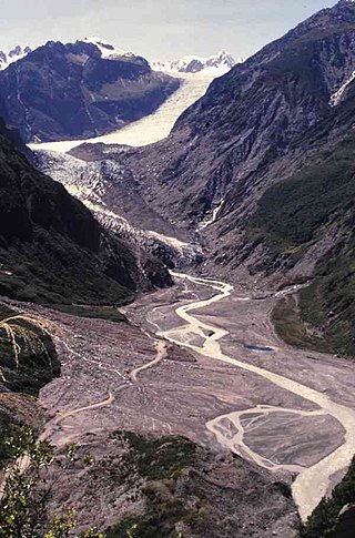
Fox Glacier is a 13-kilometre-long (8.1 mi) temperate maritime glacier located in Westland Tai Poutini National Park on the West Coast of New Zealand's South Island. Like nearby Franz Josef Glacier, Fox Glacier is one of the most accessible glaciers in the world, with a terminal face as low as 300 m above sea level, close to the village of Fox Glacier. It is a major tourist attraction and about 1000 people daily visit it during high tourist season.

The Ōrongorongo River runs for 32 kilometres (20 mi) southwest through the Ōrongorongo Valley in the southern Remutaka Ranges of the North Island of New Zealand. The river and its associated catchments lie within the bounds of the Remutaka Forest Park, which is administered by the Department of Conservation.

Crooked River is a river that flows from headwaters in the Southern Alps to Lake Brunner in the West Coast region of New Zealand's South Island. It is named for the erratic path it takes. Near Lake Brunner, it passes through reasonably flat farmland, but closer to its source, it rushes through gorges and rapids. One tributary is the Poerua River from Lake Poerua.

The Perth River is a river in the Southern Alps in the West Coast region of New Zealand's South Island. Its source is in terrace icefields north of the Rangitata Divide and is joined by multiple tributaries, including a creek from Abel Lake. It features a number of rapids and passes through two gorges before meeting the Whataroa River. The river is largely inaccessible, but recently, an adventure tourism company has begun offering "heli-rafting" on the river: whitewater rafters are flown in by helicopter to raft the river.

Tieke Kāinga is a small Māori community in New Zealand, on the middle reaches of the Whanganui River 2.5 kilometres (1.6 mi) downstream from the mouth of the Mangatiti Stream. It is centred on Tieke Marae, and a Department of Conservation tramping hut. The surrounding land is subject to a Māori land claim that began with occupation of an earlier hut in 1993.

The Anne River is a small river in Canterbury, New Zealand. It rises near the Anne Saddle and flows east then north for approximately 6 kilometres (4 mi) until it meets the Henry River, itself a tributary of the Waiau Uwha River. The St James Walkway, a popular tramping track, follows the Anne River for its entire length, and the Anne Huts are located near the river's mouth.
The Deception River is a river in New Zealand. It is a tributary of the West Coast's Ōtira River, flowing generally north for 17 kilometres (11 mi) from its source on the slopes of Mount Franklin. It passes close to Goat Pass, which gives access to the Mingha River. Almost the entire length of the river is within the Arthur's Pass National Park.
The Douglas River, formerly known as the Twain, is a river of the West Coast of New Zealand's South Island. Its source is high in the Southern Alps / Kā Tiritiri o te Moana, five kilometres (3.1 mi) south of Mount Sefton, and its upper reaches are fed by water from the Douglas Glacier. It flows west for 18 kilometres (11 mi), joined by runoff from the Horace Walker Glacier, before joining the waters of the Karangarua River. The Douglas River's entire course is within Westland Tai Poutini National Park. The river and glacier are named after Charles Edward Douglas, a 19th-century explorer and mountaineer.

The Hāpuku River begins in the Seaward Kaikōura Range of New Zealand and flows south-east to enter the South Pacific at Hapuka, between Clarence and Kaikōura. The name comes from the Māori word hāpuku or hāpuka, a deep-water marine fish. Its main tributary is the Puhi Puhi River.

The Fox River is a river in the Buller District of New Zealand. It arises in the Paparoa Range near Mount Dewar and flows north-west through the Paparoa National Park to the Tasman Sea at Woodpecker Bay. The river passes through a spectacular gorge. The northern branch of the river has limestone caves containing stalactite and stalagmite formations.

A hapua is a river-mouth lagoon on a mixed sand and gravel (MSG) beach, formed at the river-coast interface where a typically braided, although sometimes meandering, river interacts with a coastal environment that is significantly affected by longshore drift. The lagoons which form on the MSG coastlines are common on the east coast of the South Island of New Zealand and have long been referred to as hapua by Māori people. This classification differentiates hapua from similar lagoons located on the New Zealand coast termed waituna.
Milford Huts is a bach community in the Timaru district and Canterbury region of New Zealand's South Island. Milford Huts is on the northern side of the Ōpihi River mouth, 7.5 kilometres southeast of Temuka by road.
Waipopo or Waipopo Huts is a bach community in the Timaru district and Canterbury region of New Zealand's South Island. Waipopo is on the southern side of the Ōpihi River mouth, 11.5 kilometres southeast of Temuka and 17.3 northeast of Timaru by road.

The Wangapeka Track is a tramping track in the north-west of the South Island of New Zealand. It is one of the main tramping tracks in the Kahurangi National Park, a protected area managed by the Department of Conservation. The route traverses the southern end of the park from the historic Wangapeka goldfields area west of Tapawera to the coastal plains of the West Coast at Little Wanganui. The route is 59 km (37 mi) long and crosses the Wangapeka and Little Wanganui saddles, each over 1,000 m (3,300 ft) in elevation. The track passes through the valleys of the Wangapeka River, Karamea River, Taipō River and Little Wanganui River. The majority of the track is in river valleys and under forest cover, with small sections in tussock land at Stag Flat and the Little Wanganui Saddle. It typically takes walkers 4–6 days to complete the route.

The historic Haast to Paringa Cattle Track is a trail through South Westland, New Zealand, constructed in 1875 to allow farmers in the Landsborough and Cascade Valley area to drive their cattle on an annual two-week journey to the sale yards in Whataroa. It was constructed as an inland loop to bypass the precipitous cliffs at Knights Point. For 90 years it was the only land access to the settlements of Haast and Jackson Bay, but the last mob of cattle was driven in 1961, and the construction of a highway connecting Paringa to Haast Pass in 1965 made it redundant. After falling into disuse, the cattle track was converted into a 33-kilometre (21 mi), three-day tramping track, opening in 1981. The track and its three huts are maintained by the New Zealand Department of Conservation.
