
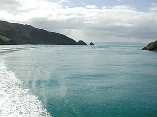
Arapaoa Island is the second-largest island in the Marlborough Sounds, at the north-east tip of the South Island of New Zealand. The island has a land area of 75 km2. Queen Charlotte Sound defines its western side, while to the south lies Tory Channel, which is on the sea route between Wellington in the North Island to Picton. Cook Strait's narrowest point is between Arapaoa Island's Perano Head and Cape Terawhiti in the North Island.

Cook Strait is a strait that separates the North and South Islands of New Zealand. The strait connects the Tasman Sea on the northwest with the South Pacific Ocean on the southeast. It is 22 kilometres (14 mi) wide at its narrowest point, and is considered one of the most dangerous and unpredictable waters in the world. Regular ferry services run across the strait between Picton in the Marlborough Sounds and Wellington.

Oban is the principal settlement on Stewart Island, the southernmost inhabited island of the New Zealand archipelago. Oban is centred on Halfmoon Bay, and stretches over a peninsula to Paterson Inlet. It has aircraft connections with Invercargill and a ferry service to Bluff, both on the mainland South Island.

Kahurangi National Park is a national park in the northwest of the South Island of New Zealand. It is the second largest of the thirteen national parks of New Zealand. It was gazetted in 1996 and covers 5,193 km2 (2,005 sq mi), ranging from the Buller River near Murchison in the south, to the base of Farewell Spit in Golden Bay in the north. The park has no single dominant landform, but includes an unusually wide variety of landscapes, including mountain ranges, rivers, gorges, raised peneplains and karst features such as caves and arches. Many of the landforms within the park are considered to be nationally or internationally significant.
Tory Channel is one of the drowned valleys that form the Marlborough Sounds in New Zealand. Inter-island ferries normally use it as the principal channel between Cook Strait and the Marlborough Sounds.

Farewell Spit is a narrow sand spit at the northern end of the Golden Bay, in the South Island of New Zealand. The spit includes around 25 km (16 mi) of stable land and another 5 km (3.1 mi) of mobile sand spit running eastwards from Cape Farewell, the northern-most point of the South Island. Farewell Spit is the longest sand spit in New Zealand, and is a legally protected Nature Reserve. The area is designated as a Ramsar wetland site and an East Asian–Australasian Flyway Shorebird Network site. Farewell Spit is administered by the Department of Conservation as a seabird and wildlife reserve. Apart from a small area at the base of the spit, it is closed to the public except through organised tours. Conservation initiatives are in progress towards eliminating mammalian predators from Farewell Spit, including a proposal for a predator-proof fence.
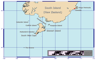
Foveaux Strait is a strait that separates Stewart Island from the South Island of New Zealand. The width of the strait ranges from about 23 to 53 km, and the depth varies between 18 and 46 m. The strait was first charted by an American sealer, Owen Folger Smith. He charted the strait from a whaleboat of the sealing brig Union in 1804.

Lake Pukaki is the largest of three roughly parallel alpine lakes running north–south along the northern edge of the Mackenzie Basin on New Zealand's South Island. The others are Lakes Tekapo and Ōhau. All three lakes were formed when the terminal moraines of receding glaciers blocked their respective valleys, forming moraine-dammed lakes. The Alps2Ocean mountain bike trail follows the edge of Lake Pukaki for part of its length.

Ruapuke Island is one of the southernmost islands in New Zealand's main chain of islands. It is located 15 kilometres (9.3 mi) to the southeast of Bluff and 32 kilometres (20 mi) northeast of Oban on Stewart Island. It was named "Bench Island" upon its discovery by Captain James Cook in 1770, but has rarely been known by any other name than its Māori name, which means "two hills".

The Hikurangi Trough is a sea floor feature of the Pacific Ocean off the north-east South Island and the east coast of the North Island of New Zealand. It has been forming for about 25 million years and is turbidite-filled, particularly in its south. This characteristic can be used to distinguish it from the sediment-poor and deeper Kermadec Trench, which is its continuation to the north. Sediment currently passing through the trough represents about 0.5% of the total sediment input to the world oceans. The trough has deep-sea chemosynthetic ecosystems that are unique.

Little Barrier Island, or Hauturu in Māori, lies off the northeastern coast of New Zealand's North Island. Located 80 kilometres (50 mi) to the north of Auckland, the island is separated from the mainland to the west by the Jellicoe Channel, and from the larger Great Barrier Island to the east by the Cradock Channel. The two aptly named islands shelter the Hauraki Gulf from many of the storms of the Pacific Ocean.

Planchonella costata is a small coastal tree native to the northern North Island and to Norfolk Island (Australia). In New Zealand, its common name is tawapou ; on Norfolk Island it is called bastard ironwood. The name costata is from the Latin costatus (ribbed), a reference to the prominently raised primary nerves of the leaves.

Nestegis apetala is a small tree native to northern New Zealand and to Norfolk Island. The common names in New Zealand are coastal maire or broad-leaved maire. On Norfolk Island, the common name is ironwood. The species name apetala refers to the lack of petals on the flowers.

Commercial whaling in New Zealand waters began late in the 18th century and continued until 1965. It was a major economic activity for Europeans in New Zealand in the first four decades of the 19th century. Nineteenth-century whaling was based on hunting the southern right whale and the sperm whale and 20th-century whaling concentrated on the humpback whale.
The geology of New Zealand is noted for its volcanic activity, earthquakes and geothermal areas because of its position on the boundary of the Australian Plate and Pacific Plates. New Zealand is part of Zealandia, a microcontinent nearly half the size of Australia that broke away from the Gondwanan supercontinent about 83 million years ago. New Zealand's early separation from other landmasses and subsequent evolution have created a unique fossil record and modern ecology.

Stewart Island is New Zealand's third-largest island, located 30 kilometres south of the South Island, across Foveaux Strait. It is a roughly triangular island with a land area of 1,746 km2 (674 sq mi). Its 164-kilometre (102 mi) coastline is indented by Paterson Inlet (east), Port Pegasus (south), and Mason Bay (west). The island is generally hilly and densely forested. Flightless birds, including penguins, thrive because there are few introduced predators. Almost all the island is owned by the New Zealand government, and over 80 per cent of the island forms Rakiura National Park.
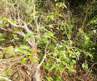
Ripogonum scandens is a common rainforest vine endemic to New Zealand. The species was described by Johann Reinhold Forster, and Georg Forster in 1776. It has a conservation status of Not Threatened.

Geodorcus ithaginis, the Mokohinau stag beetle, is a large flightless species of stag beetle in the family Lucanidae. It was described by Thomas Broun in 1893 after being discovered in the Mokohinau Islands by Andreas Stewart Sandager, a lighthouse keeper on the islands. The species survives only on the small unnamed island "Stack H", in a patch of vegetation the size of a living room, and is in extreme danger of extinction.
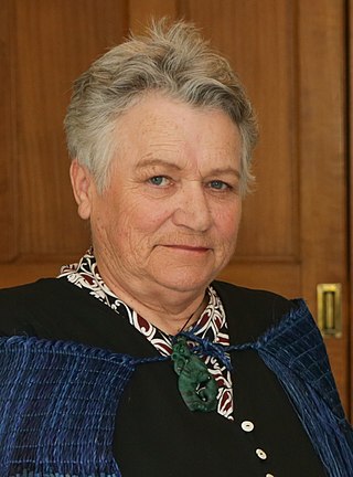
Ramari Evelyn Sidonie Oliphant Stewart is a New Zealand Māori whale expert. Her iwi affiliations are Ngāti Awa, Rongomaiwahine, and Ngāti Mahuta. She was appointed a Member of the New Zealand Order of Merit in the 2020 Queen's Birthday Honours, for services Māori culture and wildlife conservation and research. The newly discovered Ramari's beaked whale is named in her honour. Stewart had assisted in the recovery and preparation of this pregnant female, thought at the time to be a True's beaked whale in 2012.
Capital punishment is not a legal penalty in Niue. While the death penalty was legal under New Zealand colonial rule, and death sentences were imposed by the courts, no executions were ever carried out. Capital punishment has been illegal in Niue since 1966, when the death penalty was effectively abolished by New Zealand colonial authorities.

