Related Research Articles

Toetoes Bay is the easternmost of three large bays lying on the Foveaux Strait coast of Southland, New Zealand, the others being Te Waewae Bay and Oreti Beach. The 240 km Mataura River drains to sea at Toetoes Bay, first passing through the Toetoes Harbour estuary. Thirty kilometres in length, the bay is the southern end of the Awarua Plain, an area of swampy land stretching inland for about fifteen kilometres. The eastern end of the bay is close to Slope Point, the South Island's southernmost point, and the western end of the Catlins.
The Possession Islands are a group of small islands and rocks extending over an area of about 7 nautical miles, lying in the western part of the Ross Sea, lying 5 nautical miles south-east of Cape McCormick, in Victoria Land, Antarctica. The Possession Islands were named by Captain James Clark Ross, Royal Navy, in commemoration of the planting of the British flag here on January 12, 1841.
Borchgrevink Glacier is a large glacier in the Victory Mountains, Victoria Land, Antarctica. It drains south between Malta Plateau and Daniell Peninsula, and thence projects into Glacier Strait, Ross Sea, as a floating glacier tongue.
The Millen Range is a prominent northwest–southeast trending mountain range, located west of the Cartographers Range in the Victory Mountains of Antarctica. Peaks in the range include Inferno, Omega, Le Couteur, Head, Cirque, Gless, Turret, Crosscut and Mount Aorangi. It was named by the New Zealand Federated Mountain Clubs Antarctic Expedition (NZFMCAE) of 1962–63, for John M. Millen, leader of the expedition.
The Wilkniss Mountains form a prominent group of conical peaks and mountains, 10 nautical miles (19 km) long running north–south, located 9 nautical miles east-southeast of Mount Feather in the Quartermain Mountains, Victoria Land, Antarctica. The mountains are 3 nautical miles wide in the north portion where Mount Blackwelder, 2,340 metres (7,680 ft) high, and Pivot Peak 2,450 metres (8,040 ft) high, rise above ice-free valleys. Except for an outlying southwest peak, the south portion narrows to a series of mainly ice-covered smaller peaks.
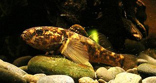
The common bully, or toitoi (Māori), is a fish endemic to New Zealand, and is present throughout the country. There are three other bully species that can be confused with common bullies. There are few characteristics of the common bully that separate it from other species. Vertical lines present on the cheek are a good defining characteristic, along with the location of head pores and scale patterns on the head although these are hard to establish when seen in the wild. It is an amphidromous fish meaning it is able to survive in marine and fresh water environments. It is a small fish only growing as big as 15 cm. It can live in marine, fresh water or brackish water habitats and generally lives in benthic zones. Some populations venture into the sea and occur in coastal rivers and streams while other land-locked populations have established in many shallow mainland lakes. They generally prefer moderate to slow moving water which means they are the most likely bully species to be sighted. Its diet consists mainly of small benthic invertebrates but also involves insect larvae and crustacea.
Lennox-King Glacier is a large valley glacier, about 40 nautical miles (70 km) long that flows east into the Ross Ice Shelf.
The Hinds River is a river in the Canterbury region of New Zealand. Its north and south branches drain the eastern flank of the Moorhouse Range, part of the Southern Alps, and their confluence is near Anama and Mayfield. The river then flows across the Canterbury Plains towards the Pacific Ocean, passing through the small town of Hinds along the way. In Hinds, State Highway 1 and the Main South Line railway cross the river. The river's mouth is located between the localities of Longbeach and Lowcliffe.
Explorers Range is a large mountain range in the Bowers Mountains of Victoria Land, Antarctica, extending from Mount Bruce in the north to Carryer Glacier and McLin Glacier in the south.
Alamein Range is a range lying west of Canham Glacier, in the Freyberg Mountains of Antarctica. It was named in association with Lord Bernard Freyberg and the Second New Zealand Expeditionary Force by the Northern Party of New Zealand Geological Survey Antarctic Expedition (NZGSAE), 1963–64.
Port Pegasus, officially Port Pegasus / Pikihatiti, is at the southern end of Stewart Island in New Zealand. From the 1890s to the 1950s, Port Pegasus was the site of a small fishing community. There was also a small tin-mining boom in the area in the 1890s. Today, there is no settlement at Port Pegasus, but the location is frequented by tourists, fishermen, hunters, and divers.
The Ihungia River is a river of the northeastern North Island of New Zealand. It flows north from its source inland from Te Puia Springs, joining with the Mata River 15 kilometres (9 mi) southwest of Ruatoria.
The Kopeka River is a river of Stewart Island / Rakiura, New Zealand. Rising east of Mount Allen, it flows south-eastward into the sea west of Toitoi Bay.

The Pourakino River is a river in New Zealand, flowing into the Jacobs River Estuary at Riverton.
The Rakeahua River is a river in Stewart Island / Rakiura, New Zealand, flowing into Paterson Inlet.
The Robertson River is a river in Stewart Island / Rakiura, New Zealand. It rises to the east of the Tin Range and flows into the sea east of Port Pegasus.

The Waita River is in the West Coast Region of New Zealand's South Island. It flows generally west to reach the Tasman Sea 10 kilometres northeast of the mouth of the Haast River. The river has its source on the western flanks of the Mataketake Range and passes through dense native forest which opens up into farm land before passing under the State Highway 6. The Maori River is one of the tributaries of the Waita.
Rampart Ridge is a prominent broken ridge on the west side of the Royal Society Range, Antarctica. It stands north of Rutgers Glacier and extends from The Spire to Bishop Peak.
Stewarts Brook, a perennial stream of the Hunter River catchment, is located in the Hunter region of New South Wales, Australia.
References
"Place name detail: Toitoi River". New Zealand Gazetteer. New Zealand Geographic Board . Retrieved 12 July 2009.
47°07′S167°59′E / 47.117°S 167.983°E