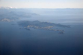
D'Urville Island, Māori name Rangitoto ki te Tonga, is the largest island in the Marlborough Sounds, on the northern coast of the South Island of New Zealand. It was named after the French explorer Jules Dumont d'Urville. With an area of approximately 150 square kilometres (58 sq mi), it is the eighth-largest island of New Zealand, and has around 52 permanent residents. The local authority is the Marlborough District Council.

The South Island is the largest of the three major islands of New Zealand in surface area, the others being the smaller but more populous North Island and sparsely populated Stewart Island. It is bordered to the north by Cook Strait, to the west by the Tasman Sea, to the south by the Foveaux Strait and Southern Ocean, and to the east by the Pacific Ocean. The South Island covers 150,437 square kilometres (58,084 sq mi), making it the world's 12th-largest island, constituting 56% of New Zealand's land area. At low altitudes, it has an oceanic climate. The major centres are Christchurch, with a metropolitan population of 521,881, and the smaller Dunedin. The economy relies on agriculture, fishing, tourism, and general manufacturing and services.

The Tasman Sea is a marginal sea of the South Pacific Ocean, situated between Australia and New Zealand. It measures about 2,000 km (1,200 mi) across and about 2,800 km (1,700 mi) from north to south. The sea was named after the Dutch explorer Abel Janszoon Tasman, who in 1642 was the first known person to cross it. British explorer Lieutenant James Cook later extensively navigated the Tasman Sea in the 1770s during his three voyages of exploration.

The southern right whale is a baleen whale, one of three species classified as right whales belonging to the genus Eubalaena. Southern right whales inhabit oceans south of the Equator, between the latitudes of 20° and 60° south. In 2009 the global population was estimated to be approximately 13,600.

Shepherd's beaked whale, also commonly called Tasman's beaked whale or simply the Tasman whale, is a cetacean of the family Ziphiidae and the only species in the genus Tasmacetus. The whale has not been studied extensively. Only four confirmed at sea sightings have been made and 42 strandings recorded. It was first known to science in 1937, being named by W. R. B. Oliver after George Shepherd, curator of the Wanganui Museum, who collected the type specimen near Ohawe on the south Taranaki coast of New Zealand's North Island, in 1933.

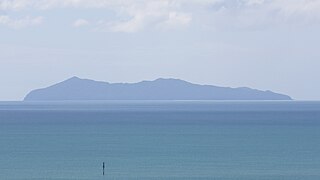
Chatham Island is the largest island of the Chatham Islands group, in the south Pacific Ocean off the eastern coast of New Zealand's South Island. It is said to be "halfway between the equator and the pole, and right on the International Date Line", although that point is 173 miles WSW of the island's westernmost point. The island is called Rekohu in Moriori, and Wharekauri in Māori.

Hector's dolphin is one of four dolphin species belonging to the genus Cephalorhynchus. Hector's dolphin is the only cetacean endemic to New Zealand, and comprises two subspecies: C. h. hectori, the more numerous subspecies, also referred to as South Island Hector's dolphin; and the critically endangered Māui dolphin, found off the West Coast of the North Island.

Moturoa / Rabbit Island is a small island that lies across the southernmost part of Tasman Bay / Te Tai-o-Aorere, on the northern coast of New Zealand's South Island. The long narrow island runs east–west for 8 kilometres (5 mi), and covers 15 km2 (5.8 sq mi).

The Snares Islands, known colloquially as The Snares, is a group of uninhabited islands lying about 200 km (120 mi) south of New Zealand's South Island and to the south-southwest of Stewart Island / Rakiura. The Snares consist of the main North East Island and the smaller Broughton Island and Alert Stack, as well as the Western Chain Islands some 5 km (3.1 mi) to the west-southwest. Collectively, the Snares have a total land area of 3.4 km2 (1.3 sq mi).
Mayor Island / Tūhua is a dormant shield volcano located off the Bay of Plenty coast of New Zealand's North Island. It lies 35 kilometres (22 mi) north of Tauranga and covers 13 km2 (5 sq mi).

Greymouth Airport is a small, uncontrolled aerodrome located in the suburb of Blaketown, 1 Nautical mile (1.9 km) south of the Greymouth CBD on the West Coast of the South Island of New Zealand.
The first Christian mission is established at Rangihoua. The Hansen family, the first non-missionary family also settles there. Samuel Marsden explores the Hauraki Gulf and travels to within sight of Tauranga Harbour. The first book in Māori is published in Sydney. The first European is born in New Zealand.
By the end of the year reports from London regarding Napoleon's retreat from Moscow, and from the Bay of Islands regarding the hospitality of the Māori, encourage Samuel Marsden into thinking the time for the establishment of a Christian mission to New Zealand is now imminent.
There are no known visits by sealers this year as they concentrate on Bass Strait. However Charles Bishop and George Bass call at Dusky Sound in the Venus where they spend fourteen days stripping iron from the hulk of Captain Brampton's old ship the Endeavour, to barter in Tahiti for pork before returning to Sydney in November. There are several British whalers operating off the north-east coast, only one of which is certainly known to have landed. There are an unknown number of American whalers also in the area but as they do not usually call at Port Jackson their activities, including where, if at all, they land, are largely unknown.

The 2007 Gisborne earthquake occurred under the Pacific Ocean about 50 kilometres (31 mi) off the eastern coast of New Zealand's North Island at 8:55 pm NZDT on 20 December. With a moment magnitude of 6.7 and maximum Mercalli intensity of VII, the tremor affected the city of Gisborne and was felt widely throughout the country, from Auckland in the north to Dunedin in the south.

Tapuae Marine Reserve is a marine reserve created in 2008 off the Taranaki coast of New Zealand.
The Open Bay Islands are located in South Westland, off the south-west coast of the South Island of New Zealand. They consist of two main islands, Taumaki and Popotai, plus several smaller islets and rocks. They lie approximately 5 km (3.1 mi) offshore from the Okuru River mouth, near Haast, and are owned by the West Coast branch Māori iwi Ngāi Tahu known as Poutini Ngāi Tahu.
Kapiti Marine Reserve is a protected area on two sides of Kapiti Island, off the southern west coast of the North Island of New Zealand. It was created in 1992.

Tonga Island is a small (0.15 km2) island in Tasman Bay / Te Tai-o-Aorere, off the northern coast of the South Island of New Zealand. It lies within the Abel Tasman National Park, about 1 kilometre (0.62 mi) off Onetahuti Beach. The island has a flourishing fur seal colony, and is surrounded by the Tonga Island Marine Reserve, which was inaugurated in 1993.

Recreational dive sites are specific places that recreational scuba divers go to enjoy the underwater environment or for training purposes. They include technical diving sites beyond the range generally accepted for recreational diving. In this context all diving done for recreational purposes is included. Professional diving tends to be done where the job is, and with the exception of diver training and leading groups of recreational divers, does not generally occur at specific sites chosen for their easy access, pleasant conditions or interesting features.
