Related Research Articles

The Tasman Sea is a marginal sea of the South Pacific Ocean, situated between Australia and New Zealand. It measures about 2,000 km (1,200 mi) across and about 2,800 km (1,700 mi) from north to south. The sea was named after the Dutch explorer Abel Janszoon Tasman, who in 1642 was the first known person to cross it. British explorer Lieutenant James Cook later extensively navigated the Tasman Sea in the 1770s during his three voyages of exploration.

Mount Erebus is the second-highest volcano in Antarctica, the highest active volcano in Antarctica, and the southernmost active volcano on Earth. It is the sixth-highest highest point of an island, and the second most prominent mountain in Antarctica after Mount Vinson. It has a summit elevation of 3,794 metres (12,448 ft). It is located in the Ross Dependency on Ross Island, which is also home to three inactive volcanoes: Mount Terror, Mount Bird, and Mount Terra Nova. The mountain was named by Captain James Clark Ross in 1841 for his ship, the Erebus.
The Murray River is a minor river on Stewart Island / Rakiura of New Zealand. It enters the Foveaux Strait sea on the eastern side of the island.

The Waiau River is the largest river in the Southland region of New Zealand. 'Waiau' translates to 'River of Swirling Currents'. It is the outflow of Lake Te Anau, flowing from it into Lake Manapouri 10 kilometres (6 mi) to the south, and from there flows south for 70 kilometres (43 mi) before reaching the Foveaux Strait 8 kilometres (5 mi) south of Tuatapere. It also takes water from Lake Monowai.
Borchgrevink Glacier is a large glacier in the Victory Mountains, Victoria Land, Antarctica. It drains south between Malta Plateau and Daniell Peninsula, and thence projects into Glacier Strait, Ross Sea, as a floating glacier tongue.

Pahia is a small rural locality in coastal Southland, New Zealand, not to be confused with the North Island tourist resort of Paihia. Surrounding areas include Ruahine, Wakapatu, Round Hill, Colac Bay and Orepuki. The main road, Orepuki-Riverton Hwy, runs through it. Pahia is 15 minutes from Riverton, 20 minutes from Tuatapere and 45 minutes from Invercargill.
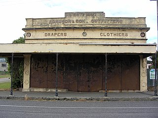
Orepuki in Southland, New Zealand is a small country township on the coast of Te Waewae Bay some 20 minutes from Riverton, 15 minutes from Tuatapere and 50 minutes from Invercargill that sits at the foot of the Longwood Range. Once a thriving gold mining settlement of 3000 people, today Orepuki is something of a ghost town with an assortment of abandoned stores, goldmining relics and sluicing scars as the only reminders of its former glory.
Colac Bay / Ōraka is a small township situated on the bay of the same name facing Foveaux Strait, and located on the Southern Scenic Route, 10 minutes from Riverton, New Zealand. Surrounding areas include Longwood, Tihaka, Waipango, Round Hill, Wakapatu, Ruahine, Pahia and Orepuki.
Southland District Council is the territorial authority for the Southland District of New Zealand.
The Freshwater River is the longest river on Stewart Island, the third largest of New Zealand's islands. It arises close to the island's northwestern point, from which it is separated by a ridge, and flows southeastward through the Ruggedy Flat for 25 kilometres (16 mi) before reaching the Paterson Inlet on the island's central east coast. The Freshwater is the longest New Zealand river not to be located in either of the country's two main islands.

The Clifden Suspension Bridge is a historic suspension bridge near Clifden, New Zealand with a single lane. Built in 1899, it spans the Waiau River and is 111.5 m long.
The Light River is a river of Fiordland, New Zealand. It rises west of Lake Quill and flows westward into Te Hāpua / Sutherland Sound.

The Ōkārito River is a river of the West Coast Region of New Zealand's South Island. It flows northwest from the northern end of Lake Mapourika, reaching the Ōkārito Lagoon 15 kilometres west of Whataroa.
The Orauea River is a river in New Zealand, a tributary of the Waiau River in Southland.
The Pourakino River is a river in New Zealand, flowing into the Jacobs River Estuary at Riverton.
The Rakeahua River is a river in Stewart Island/Rakiura, New Zealand, flowing into Paterson Inlet.
The Waimeamea River is a river in the Southland Region of New Zealand. It rises in the Longwood Range and flows south-eastward into Te Waewae Bay north of Orepuki.

The Wairaurāhiri River is a river in southern Fiordland, New Zealand, draining Lake Hauroko into the sea. Many boats have got into trouble along its length, as the river flows quite quickly with grade-3 rapids, so the main boats that use the river are commercial jetboats. There is a 157-metre (515 ft) drop from the source at Lake Hauroko to the mouth, which empties into Foveaux Strait.
The Waitutu River is a river in southern Fiordland, New Zealand. It is the outlet of Lake Poteriteri to the sea.
The Longwood Range is a range of hills to the west of the Southland Plains, Southland, New Zealand. From the 1860s until the 1950s gold mining was prevalent in the Longwood Ranges. There are many small towns and localities situated around the periphery of these hills: clockwise from the south-east, these include Riverton, Pourakino Valley, Colac Bay, Pahia, Orepuki, Tuatapere, Otautau and Thornbury.
References
- ↑ "Place name detail: Tolson River". New Zealand Gazetteer. New Zealand Geographic Board . Retrieved 25 June 2010.
46°53′51″S167°57′36″E / 46.897431°S 167.959879°E