
The Manukau Harbour is the second largest natural harbour in New Zealand by area. It is located to the southwest of the Auckland isthmus, and opens out into the Tasman Sea.

Rakiura National Park is a nature reserve park located on Stewart Island / Rakiura, New Zealand. It is the newest national park of New Zealand and opened in 2002. The protected area covers about 85% of the island.

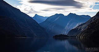
Fiordland is a geographical region of New Zealand in the south-western corner of the South Island, comprising the westernmost third of Southland. Most of Fiordland is dominated by the steep sides of the snow-capped Southern Alps, deep lakes, and its steep, glacier-carved and now ocean-flooded western valleys. The name "Fiordland" comes from a variant spelling of the Scandinavian word for this type of steep valley, "fjord". The area of Fiordland is dominated by, and very roughly coterminous with, Fiordland National Park, New Zealand's largest National Park.

Lake Wakatipu is an inland lake in the South Island of New Zealand. It is in the southwest corner of the Otago region, near its boundary with Southland. Lake Wakatipu comes from the original Māori name Whakatipu wai-māori.
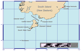
Foveaux Strait is a strait that separates Stewart Island from the South Island of New Zealand. The width of the strait ranges from about 23 to 53 km, and the depth varies between 18 and 46 m. The strait was first charted by an American sealer, Owen Folger Smith. He charted the strait from a whaleboat of the sealing brig Union in 1804.

Ruapuke Island is one of the southernmost islands in New Zealand's main chain of islands. It is located 15 kilometres (9.3 mi) to the southeast of Bluff and 32 kilometres (20 mi) northeast of Oban on Stewart Island. It was named "Bench Island" upon its discovery by Captain James Cook in 1770, but has rarely been known by any other name than its Māori name, which means "two hills".

Te Awarua-o-Porirua Harbour, commonly known as Porirua Harbour, is a natural inlet in the south-western coast of the North Island of New Zealand.

Rakituma / Preservation Inlet is the southernmost fiord in Fiordland National Park and lies on the southwest corner of the South Island of New Zealand. With an area of 93 square kilometres (36 sq mi), it is the fourth largest fiord in New Zealand, after Tamatea / Dusky Sound, Doubtful Sound / Patea, and the neighbouring Taiari / Chalky Inlet to the north. Rakituma was briefly the site of an attempted fishing and gold mining settlement at Cromarty during the 19th century, however this was quickly abandoned once the level of gold declined in relation to more promising fields elsewhere.

Stewart Island is New Zealand's third-largest island, located 30 kilometres south of the South Island, across Foveaux Strait. It is a roughly triangular island with a total land area of 1,746 km2 (674 sq mi). Its 164-kilometre (102 mi) coastline is deeply indented by Paterson Inlet (east), Port Pegasus (south), and Mason Bay (west). The island is generally hilly and densely forested. Flightless birds, including penguins, thrive because there are few introduced predators. Almost all the island is owned by the New Zealand government, and over 80 per cent of the island is set aside as the Rakiura National Park.

Southland is New Zealand's southernmost region. It consists of the southwestern portion of the South Island and includes Stewart Island. Southland is bordered by the culturally similar Otago Region to the north and east, and the West Coast Region in the extreme northwest. The region covers over 3.1 million hectares and spans 3,613 km of coastline. As of June 2023, Southland has a population of 103,900, making it the eleventh-most-populous New Zealand region, and the second-most sparsely populated. Approximately half of the region's population lives in Invercargill, Southland's only city.
Whanganui Inlet, commonly known by its former name Westhaven Inlet or West Haven, is a large natural indentation in the northwest coast of the South Island of New Zealand.

Pūrākaunui is a small settlement in Otago, in the South Island of New Zealand. It is located within the bounds of the city of Dunedin, in a rural coastal area some 25 km to the north of the city centre.
Taiari / Chalky Inlet is one of the southernmost fiords in Fiordland, in the southwestern corner of New Zealand's South Island and part of Fiordland National Park. As with the neighbouring fiords of Tamatea / Dusky Sound to the north and Rakituma / Preservation Inlet to the south, Taiari / Chalky Inlet is a complex fiord with many channels and islands along its roughly 28 km (17 mi) length. Most notably, this includes the sections Moana-whenua-pōuri / Edwardson Sound and Te Korowhakaunu / Kanáris Sound, which split at Divide Head in the middle of Taiari and each extend for roughly 10 km (6.2 mi) inland in a V-shape.

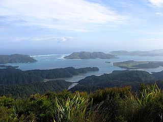
Ulva Island-Te Wharawhara Marine Reserve is a marine reserve covering an area of 1,075 hectares south-west and north-east of Ulva Island, in the Paterson Inlet of New Zealand's Stewart Island. It was established in 2004 and is administered by the Department of Conservation.

Punakaiki Marine Reserve is a marine reserve administered by the Department of Conservation. The reserve includes the area of sea surrounding the pancake rocks and blowholes at Dolomite Point, at Punakaiki on the West Coast Region of New Zealand's South Island. It also includes most of the coastline on the western edge of Paparoa National Park.

Tauparikākā Marine Reserve is a marine reserve located offshore about 20 kilometres (12 mi) north of Haast on the West Coast of New Zealand's South Island. It covers the area immediately offshore from Ship Creek, which is also known as Tauparikākā in Māori.

Taumoana Marine Reserve is a marine reserve covering an area of 464 hectares in Fiordland on New Zealand's South Island. It was established in 2005 and is administered by the Department of Conservation. It is located next to the Five Fingers Peninsula, at the entrance to Tamatea / Dusky Sound.
Moana Uta Marine Reserve is a marine reserve covering the entire length of Wet Jacket Arm in Fiordland on New Zealand's South Island, an area of 2,007 hectares. It was established in 2005 and is administered by the Department of Conservation.

Native Island is off the east coast of Halfmoon Bay, Stewart Island, New Zealand. It is north east of Ulva Island in the northern mouth of Paterson Inlet. It is separated from Stewart Island by a narrow channel 50 metres (160 ft) in width. There has been evidence of small and temporary past Māori settlements on the island. Multiple Māori relics have been found, including bone fish hooks, axes, and chisels. Native Island is part of the Ulva Island-Te Wharawhara Marine Reserve, which is on the south part of Native Island.

