Related Research Articles
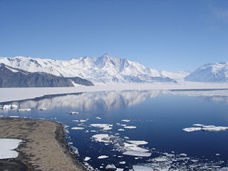
The Admiralty Mountains is a large group of high mountains and individually named ranges and ridges in northeastern Victoria Land, Antarctica. This mountain group is bounded by the sea, and by the Dennistoun Glacier, Ebbe Glacier, and Tucker Glacier.

The Dennistoun Glacier is a glacier, 50 nautical miles long, draining the northern slopes of Mount Black Prince, Mount Royalist and Mount Adam in the Admiralty Mountains of Victoria Land, Antarctica. It flows northwest between the Lyttelton Range and Dunedin Range, turning east on rounding the latter range to enter the sea south of Cape Scott.
Tucker Glacier is a major valley glacier of Victoria Land, Antarctica, about 90 nautical miles long, flowing southeast between the Admiralty Mountains and the Victory Mountains to the Ross Sea. There is a snow saddle at the glacier's head, just west of Homerun Range, from which the Ebbe Glacier flows northwestward.
This is a list of the extreme points of The Americas, the points that are farther north, south, east or west than any other location on the continent. The continent's southernmost point is often said to be Cape Horn, which is the southernmost point of the Chilean islands. The Americas cross 134° of longitude east to west and 124° of latitude north to south.
Borchgrevink Glacier is a large glacier in the Victory Mountains, Victoria Land, Antarctica. It drains south between Malta Plateau and Daniell Peninsula, and thence projects into Glacier Strait, Ross Sea, as a floating glacier tongue.
Cartographers Range is a rugged range about 25 nautical miles long in the Victory Mountains, Victoria Land in Antarctica. It is bounded on the north by Pearl Harbor Glacier, on the east by Tucker Glacier, and on the south by Hearfield Glacier and Trafalgar Glacier. Mapped by the United States Geological Survey (USGS) from surveys and United States Navy air photos, 1960–64. Named by the United States Advisory Committee on Antarctic Names (US-ACAN) for the cartographers and cartographic technicians of the Branch of Special Maps, USGS.
Lennox-King Glacier is a large valley glacier, about 40 nautical miles (70 km) long that flows east into the Ross Ice Shelf.

Liv Glacier is a steep valley glacier, 40 nautical miles long, emerging from the Antarctic Plateau just southeast of Barnum Peak and draining north through the Queen Maud Mountains to enter Ross Ice Shelf between Mayer Crags and Duncan Mountains. It was discovered in 1911 by Roald Amundsen, who named it for the daughter of Fridtjof Nansen.
The Mariner Glacier is a major glacier over 60 nautical miles long, descending southeast from the plateau of Victoria Land, Antarctica, between Mountaineer Range and Malta Plateau, and terminating at Lady Newnes Bay, Ross Sea, where it forms the floating Mariner Glacier Tongue.
The Jackson River is a river of the southwestern South Island of New Zealand. It flows predominantly northeast, flowing into the Arawhata River close to the latter's outflow into Jackson Bay.
The Otto River is a short river of the West Coast Region of New Zealand's South Island. It is one of the headwaters of the Grey River.
The Robertson River is a river in Stewart Island / Rakiura, New Zealand. It rises to the east of the Tin Range and flows into the sea east of Port Pegasus.
The Smite River is a river of the Canterbury region of New Zealand's South Island. It flows west from the Taylor Range to feed Lake Stream, the outflow of Lake Heron, which is an upper part of the Rakaia River system.
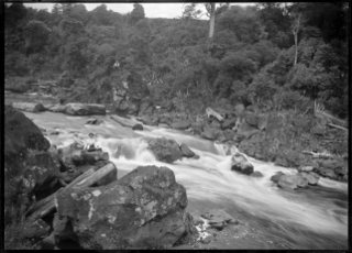
The Wairua River is a river of Northland, New Zealand. It flows south-west from Hikurangi and joins the Mangakahia River between Titoki and Tangiteroria to form the Wairoa River, which runs past Dargaville to the Kaipara Harbour.
The Holland Range is a rugged coastal mountain range in the Ross Dependency, Antarctica, on the west coast of the Ross Ice Shelf. It is about 60 nautical miles (110 km) long.

Sigaus tumidicauda is a species of alpine grasshopper, endemic to New Zealand. Like all of New Zealand sub-alpine and alpine grasshoppers, S. tumidicauda has a 2- or 3-year life cycle. The eggs must "overwinter" before they will hatch. Hoppers are found throughout the year, and adult grasshoppers can be found throughout the New Zealand summer between December and April. This grasshopper is flightless.

Pipiriki is a settlement in New Zealand, on the east bank of the Whanganui River, due west of the town of Raetihi and 79 kilometres (49 mi) upriver from Whanganui; it was originally on the opposite bank. It is the location of the Paraweka Marae of the hapū Ngāti Kurawhatia of the iwi Te Āti Haunui-a-Pāpārangi.

Koriniti is a settlement 47 kilometres (29 mi) upriver from Whanganui, New Zealand, home to the Ngāti Pāmoana hapū of the iwi Te Āti Haunui-a-Pāpārangi.
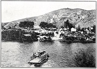
Upokongaro or Ūpokongaro is a settlement adjacent to the Whanganui River, located 12 kilometres (7.5 mi) upriver from Whanganui, New Zealand, in the Makirikiri Valley. Settled by Europeans in the 1860s, it was an important ferry crossing and riverboat stop. A spectacular discovery of moa bones was made in the area in the 1930s.
References
"Place name detail: Heron River". New Zealand Gazetteer. New Zealand Geographic Board . Retrieved 12 July 2009.
47°03′S168°10′E / 47.050°S 168.167°E