The national parks of New Zealand are protected natural areas administered by the Department of Conservation (DOC). The first national parks established in the country were all focused on mountain scenery. Since the 1980s the focus has been on developing a more diverse representation of New Zealand landscapes. The parks are all culturally significant and many also contain historic features. Tongariro National Park is one of the World Heritage Sites that are of both cultural and natural significance, while four of the South Island national parks form Te Wahipounamu, another World Heritage Site. There are currently 13 national parks; a 14th, Te Urewera National Park, was disestablished in 2014.

Aoraki / Mount Cook National Park is a national park located in the central-west of the South Island of New Zealand. It was established in October 1953 and takes its name from the highest mountain in New Zealand, Aoraki / Mount Cook. The area of the park is 707 km2 (273 sq mi), and it shares a border with Westland Tai Poutini National Park along the Main Divide of the Southern Alps. The national park consists of reserves that were established as early as 1885 to protect the area's significant landscape and vegetation. Glaciers cover 40% of the park, including the county's largest glacier, Haupapa / Tasman Glacier. In 1990, the park was included in the area designated as the Te Wāhipounamu World Heritage Site. The park is managed by the Department of Conservation (DOC) alongside Ngāi Tahu, the iwi who are mana whenua in the region.

The Department of Conservation is the public service department of New Zealand charged with the conservation of New Zealand's natural and historical heritage.

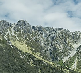
Arthur's Pass National Park is located in the South Island of New Zealand and covers 1,185 km2 of mostly mountainous terrain. Adjacent to it lies Craigieburn Forest Park. The park is administered by the Department of Conservation.

Mount Aspiring National Park is in the Southern Alps of the South Island of New Zealand, north of Fiordland National Park, situated in Otago and Westland regions. The park forms part of the Te Wahipounamu World Heritage Site.

The Whanganui National Park is a national park located in the North Island of New Zealand. Established in 1986, it covers an area of 742 km2 bordering the Whanganui River. It incorporates areas of Crown land, former state forest and a number of former reserves. The river itself is not part of the park, but is a popular paddling route titled the Whanganui Journey, one of New Zealand's "Great Walks". The New Zealand Department of Conservation highlights Whanganui National Park as being the National Park most closely tied to human settlement.
Protected areas of New Zealand are areas that are in some way protected to preserve their environmental, scientific, scenic, historical, cultural or recreational value. There are about 10,000 protected areas, covering about a third of the country. The method and aims of protection vary according to the importance of the resource and whether it is publicly or privately owned.

Craigieburn Forest Park is a protected area in the South Island of New Zealand, adjacent to Arthur's Pass National Park to the north.
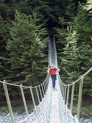
Tramping, known elsewhere as backpacking, rambling, hill walking or bushwalking, is a popular activity in New Zealand.

Pureora Forest Park is a 760-square-kilometre (290 sq mi) protected area in the North Island of New Zealand. Within its rich rainforest are an abundance of 1,000-year-old podocarp trees. It is "recognised as one of the finest rain forests in the world". Established in 1978, after a series of protests and tree sittings, the park is one of the largest intact tracts of native forest in the North Island and has high conservation value due to the variety of plant life and animal habitats. New Zealand's largest totara tree is located nearby on private land.

Tararua Forest Park, often called the Tararuas is a protected area in the Wellington region of New Zealand. Its area is 1,150 square kilometres (440 sq mi), and its highest point, a peak called Mitre, is at 1571 m above sea level. It was established in 1954, as New Zealand's first Forest Park, and is managed by the Department of Conservation (DOC) under the Conservation Act. Tararua Forest Park includes more than three-quarters of the Tararua Range, and its boundaries extend north from New Zealand State Highway 2.

Aorangi Forest Park is a 194-square-kilometre (75 sq mi) protected area in the Wellington Region of New Zealand administered by the Department of Conservation (DOC). It had been called the Haurangi Forest Park but DOC changed to reflect the Māori name of the range protected by the park.

Mount Richmond Forest Park is a forest park in New Zealand, administered by the Department of Conservation.
Kaimanawa Forest Park is a protected area south of Lake Taupō and east of Mount Tongariro in the Taupō Volcanic Zone. It is situated in the Rangitikei District and Manawatū-Whanganui Region of New Zealand's North Island.

Ka Whata Tu O Rakihouia Conservation Park is a protected area covering part of the Seaward Kaikoura Range. It is located between Kaikōura and Clarence in the Kaikōura District and Canterbury Region of New Zealand's South Island.

Te Kahui Kaupeka Conservation Park is a protected area in the Timaru District and Canterbury Region of New Zealand's South Island.

Raukumara Conservation Park or Raukūmara Conservation Park is a protected area in the Gisborne District of New Zealand's North Island.
Ruahine Forest Park is a protected area in New Zealand's North Island, predominantly in Rangitikei District in Manawatū-Whanganui.

Oteake Conservation Park is a protected area in the Waitaki District and Otago Region of New Zealand's South Island. Oteake or place of the ake is named by Kai Tahu iwi for the ake ake, a shrub daisy found throughout the park.
Northland Conservation Park is a group of protected areas in the Northland Region of New Zealand's North Island.