"},"elevation_m":{"wt":"470"},"population_footnotes":{"wt":"{{NZ population data 2018||||y}}"},"population_total":{"wt":"{{NZ population data 2018|Twizel|y}}"},"population_as_of":{"wt":"{{NZ population data 2018|||y}}"},"population_density_km2":{"wt":"auto"},"timezone":{"wt":"[[New Zealand Standard Time|NZST]]"},"utc_offset":{"wt":"+12"},"timezone_DST":{"wt":"[[New Zealand Daylight Time|NZDT]]"},"utc_offset_DST":{"wt":"+13"},"postal_code_type":{"wt":"Postcode(s)"},"postal_code":{"wt":"7901"},"area_code":{"wt":"03"}},"i":0}}]}" id="mwCw">Place in Canterbury, New Zealand
Twizel | |
---|---|
| |
![]() | |
Coordinates: 44°15′S170°06′E / 44.250°S 170.100°E | |
Country | New Zealand |
Region | Canterbury |
Territorial authority | Mackenzie District |
Ward | Pukaki Ward |
Community | Twizel Community |
Founded | 1968 |
Electorates |
|
Government | |
• Territorial authority | Mackenzie District Council |
• Regional council | Environment Canterbury |
• Mayor of Mackenzie | Anne Munro |
• Waitaki MP | Miles Anderson |
• Te Tai Tonga MP | Tākuta Ferris |
Area | |
• Total | 15.54 km2 (6.00 sq mi) |
Elevation | 470 m (1,540 ft) |
Population (June 2024) [2] | |
• Total | 1,890 |
• Density | 120/km2 (310/sq mi) |
Time zone | UTC+12 (NZST) |
• Summer (DST) | UTC+13 (NZDT) |
Postcode(s) | 7901 |
Area code | 03 |
Twizel ( /ˈtwaɪzəl/ ) is the largest town in the Mackenzie District, in the Canterbury Region of the South Island of New Zealand. The town was founded in 1968 to house construction workers on the Upper Waitaki Hydroelectric Scheme. Today, Twizel is a service and tourist town for visitors to the area. It has a resident population of 1,890 (June 2024); [2] during the summer, holidaymakers nearly triple the town's population.
Nearby Lake Ruataniwha supports rowing, sailing and water skiing. Twizel is 37 km (29 minutes drive) east of Lake Ōhau village, 30 km (20 minutes drive) north of Omarama and 60 km (42 minutes drive) south of Lake Tekapo.
The present town was built in 1968 by the Ministry of Works and Development as a greenfields project to house workers constructing the Upper Waitaki hydroelectricity scheme. [3] The name comes from the nearby Twizel River, in turn named for Twizel Bridge in Northumberland by John Turnbull Thomson, Chief Surveyor of Otago in the mid-19th century. [4]
The Waitaki hydro scheme consisted of 50 kilometres (31 mi) of canals, two dams, and four powerhouses (Tekapo B, Ōhau A, B and C), and the formation of Lake Ruataniwha, producing 848 MW of electricity. [5] [6] At the height of the project in the 1970s, population peaked of around 6,000. [7]
At the time when the construction of the Upper Waitaki hydroelectricity scheme peaked, roughly in 1976, there were 800 cabins for single people and 1,224 family homes in Twizel. These mostly belonged to the Ministry of Works and Development to house the 1,900 employees of the Upper Waitaki hydroelectricity scheme. [8]
The town was laid out in a 'Scandinavian' fashion, featuring looping roads and pedestrian ways, making it usually far more direct to walk than use a car. Shops, school, and recreational parkland formed a hub in the centre of the town, around which the residential area were built. A previous version of this layout had been tried at Otematata. Accommodation was highly segregated: in addition to single men's quarters in the middle of town, there was a series of different houses available, with the smallest for workers, staff houses for teachers and professionals, and the largest for engineers and other high-status residents. [7]
As the intention was for the town to revert to farmland, there were many temporary features. For example, instead of putting in kerbing, channels, and footpaths at the edge of the road, a single expanse of seal was contoured in a very flat 'W' shape: the seal was highest at the outer edge (footpath) and in the middle (centreline), with a lower area serving as a channel and delineation between the roadway and footpath. Likewise, most of the town's telephone local loop is strung above ground to save the task of burying and then removing the lines. Most houses were prefabricated, and intended to be portable. Some were brought from Otematata, and some were later moved to Clyde for the next hydroelectricity project.
Government ministers argued that the town was intended to be temporary and eventually demolished. The government ministers saw Twizel as a financial liability. In October 1981, 100 houses had been reserved with the intention to transport them to Aramoana in expectation that the proposed aluminium smelter would be built. [8] Several overseas investors offered to buy the whole town and develop it for tourism. One such investor, had plans to turn it into a "Las Vegas style casino town". [8]
By 1982, the population had fallen to around 3,500 people. During 1983, the Ministry of Works and Development started to sell houses and garages. Several hundred were sold and transported away by new owners. [8]
However, in 1983, as the hydroelectric project was winding up and finally ended in 1986. Residents successfully fought to save the town itself. [7] The town was handed over to the Mackenzie County Council. [9] The government offered 325 houses, 100 further sections, community facilities and a cash grant to the council. [8] The Mackenzie County Council then offered these for sale. In 1984, the Mackenzie County Council eventually took over 540 houses and 14 shops as well as the 100 sections and community facilities. [8] [10]
With the local government reorganisation that occurred in 1989, Twizel came under the auspices of the Mackenzie District Council. [8]
With the construction phase completed of the Upper Waitaki hydroelectricity scheme, the makeup of the town in the late 1980s was significantly different. The population (of 1179 people in 1986, declining to 1017 people in 1991) was now made of those working on the operations side of the hydroelectric scheme, working in the service sector, retired and those taking advantage of the cheap housing. Some houses became holiday homes for people living out of town. [8] Tourism developed slowly in the 1990s with a number of hotels and motels being built. [8]
Twizel was the base for some of the Electricity Corporation of New Zealand operations workforce. In 1999, Meridian Energy, which had inherited the local assets, moved its operations base from Twizel to Christchurch. [8]
In 2009, the community were consulted in a workshop to identify issues and gaps in services that residents felt existed. Issues identified included the viability of emergency services, accessibility of health services, residential care for the elderly, access to dental care and drug and alcohol services. [11]
In 2015, the new $1.8 million Twizel Medical Centre was completed. This included a helipad in order to transport sick patients to hospital via helicopter. [12] Meridian Energy provided $150,000 funding for the helipad. [13] [14]
A building boom occurred in 2017 with five new subdivisions all sold and a busy construction industry. [15]
Financial support to build an aviary near Twizel in order to support the conservation of the black stilt (kakī) was provided in 2017 by the Sangreal Foundation. [16] [17] The captive breeding programme in Twizel (and Christchurch) was a success in 2021 with 150 juvenile black stilt (kakī) being released into the wild. [18] The 2021 breeding season was also deemed a success with eighteen black stilt chicks hatching over the Christmas period. [19] [20] [21]
By early 2019, tourism played an important part in the economy of Twizel. By this stage, tourists had spent one million overnight stays in the town, unemployment was sitting at less than 1% and employers could not recruit for jobs. Twizel would get very busy during the summer months and during rowing events. [22]
Twizel's population is expected to grow by 2.6% each year between 2020 and 2050. with the population expected to grow to 3395 people in the year 2050. The Mackenzie District Council presented three options for how the town could evolve with the growth. in October 2020. Local residents provided negative feedback to the plans with complaints that they were too similar and said that the population growth was underestimated. [23] [24]
In January 2021, there were concerns that the display of earth moving vehicles, that was used in the Waitaki hydroelectric power projects, at the entrance to the town were unsafe. A report recommended that the vehicles were either fenced off or brought up to the standards that playgrounds are expected to be at. [25] [26]
In May 2021, work began on a $6.5 million project to replace the asbestos cement water pipes with polyethylene pipes as the old pipes had reached the end of their useful life. [27]
Twizel is described by Statistics New Zealand as a small urban area, and covers 15.54 km2 (6.00 sq mi) [1] and had an estimated population of 1,890 as of June 2024, [2] with a population density of 122 people per km2 (315/sq mi).
Year | Pop. | ±% p.a. |
---|---|---|
2006 | 1,041 | — |
2013 | 1,152 | +1.46% |
2018 | 1,455 | +4.78% |
Source: [28] |
Before the 2023 census, Twizel had a larger boundary, covering 21.07 km2 (8.14 sq mi). [1] Using that boundary, Twizel had a population of 1,455 at the 2018 New Zealand census, an increase of 303 people (26.3%) since the 2013 census, and an increase of 414 people (39.8%) since the 2006 census. There were 609 households, comprising 765 males and 687 females, giving a sex ratio of 1.11 males per female. The median age was 46.5 years (compared with 37.4 years nationally), with 213 people (14.6%) aged under 15 years, 243 (16.7%) aged 15 to 29, 681 (46.8%) aged 30 to 64, and 318 (21.9%) aged 65 or older.
Ethnicities were 87.6% European/Pākehā, 9.1% Māori, 0.8% Pasifika, 8.0% Asian, and 3.5% other ethnicities. People may identify with more than one ethnicity.
The percentage of people born overseas was 22.3, compared with 27.1% nationally.
Although some people chose not to answer the census's question about religious affiliation, 54.2% had no religion, 34.2% were Christian, 0.6% had Māori religious beliefs, 1.4% were Hindu, 1.0% were Buddhist and 1.9% had other religions.
Of those at least 15 years old, 222 (17.9%) people had a bachelor's or higher degree, and 240 (19.3%) people had no formal qualifications. The median income was $31,400, compared with $31,800 nationally. 171 people (13.8%) earned over $70,000 compared to 17.2% nationally. The employment status of those at least 15 was that 690 (55.6%) people were employed full-time, 222 (17.9%) were part-time, and 9 (0.7%) were unemployed. [28]
Twizel is now a service town for the agricultural sector and tourist town for visitors.
There are many options around Twizel for fishing. These include many mountain streams, Lakes Ruataniwha, Ōhau, and the hydroelectric canals [29] from Lake Tekapo to Lake Pukaki and those from Lake Ōhau on to Lake Benmore. Within the canals, salmon farms provide plenty of food for wild salmon and trout. Many large fish have been caught with trout weighing in excess of 4.5 kilograms common. [30] [31] [32] A trout caught in the Ōhau canal in October 2020 weighing 20.1 kg was a world record catch. [33] Twizel also hosts an annual Twizel Salmon & Wine Festival each February. [34] [35]
Lake Ruataniwha is used for sailing and water skiing. Several rowing events are held on the lake, including the Maadi Cup and the New Zealand Rowing Championships. [36] The Twizel Rowing Club is based at Lake Ruataniwha, with club members competing in all age groups. [37]
The nearby Ōhau Skifield and the Round Hill Ski Area attract winter tourists. The Twizel Snow Club supports local children to build on skills and knowledge and train for skiing and snowboarding competitions. [38] [39]
The Twizel River Trail is a 24 kilometre walk around the outskirts of Twizel. [40] Other close by walking tracks include the 15 minute long Ben Ohau Wetland track and the four hour long Darts Bush Stream track. [41] It is also possible to climb Ben Ohau. The start of the track in 23 kilometres outside of Twizel via the Glen Lyon road. [42]
Twizel is also on the route of the Alps to Ocean Cycle Trail. [43]
Stage 2 of the Alps 2 Ocean runs from Lake Tekapo to Twizel. This 54 kilometre section takes riders past the Tekapo A power station and along the Tekapo Canal before skirting around the Lake Pukaki shoreline and across the Pukaki Flats to Twizel. [44]
Stage 3 of the Alps 2 Ocean runs from Twizel to Lake Ōhau Lodge. This 38 kilometre section takes riders along the canal roads to the edge of Lake Ōhau. It then turns into an off-road trail which runs along the lake up to Lake Ōhau Lodge. This section is of an easy skill level, with little traffic. Points along the stage include the Pukaki and Ohau canals, views of Ben Ohau, Maori Swamp, the Ohau Weir and salmon fishing spots in the canals. [45]
Other mountain biking trails around Twizel include the Dusky Trail. This is a 23 kilometre walking and biking track that is considered non technical (grade 2). When biking, it is best ridden in a clockwise direction starting at Fraser Stream. [46] The Dusky Trail traverses the Ruataniwha Conservation Park. It also crosses Rhoboro, Pukaki Downs, and Ben Ohau stations on public easements. The views have been described as "massive" and showcasing the "big sky". [47]
Twizel is home to the start of the annual Twizel to Timaru Cycle Classic. The 151 kilometre race was won in 2021 by Josh Rivett. [48] The 2020 edition was won by Myles Gibson with Sharlotte Lucas coming second. [49]
The area has one of the world's cleanest, driest, and darkest skies, and has long drawn astronomers to Twizel and the surrounding area, with several existing astro-tourism ventures, such as at Lake Tekapo and Omarama, catering to their needs during the development of two additional observatories in Twizel and at Mount Cook Village. Since 2012, Twizel has been a part of the Aoraki Mackenzie International Dark Sky Reserve, one of eight dark-sky places in New Zealand recognised by the International Dark-Sky Association. [50]
Twizel has an oceanic climate. It is typically mild and dry over the summer, with cold and frosty winters. [51] Snow is not uncommon in Twizel and can fall in several months of the year. [52] Twizel is often the coldest town in New Zealand during winter. [53] [54] [55] [56] [57]
Climate data for Twizel (Pukaki Airport), elevation 461 m (1,512 ft), (1991–2020 normals, extremes 1972–present) | |||||||||||||
---|---|---|---|---|---|---|---|---|---|---|---|---|---|
Month | Jan | Feb | Mar | Apr | May | Jun | Jul | Aug | Sep | Oct | Nov | Dec | Year |
Record high °C (°F) | 35.7 (96.3) | 34.3 (93.7) | 31.0 (87.8) | 27.3 (81.1) | 25.1 (77.2) | 18.0 (64.4) | 18.5 (65.3) | 20.2 (68.4) | 24.5 (76.1) | 28.0 (82.4) | 30.4 (86.7) | 33.3 (91.9) | 35.7 (96.3) |
Mean daily maximum °C (°F) | 24.6 (76.3) | 24.6 (76.3) | 21.5 (70.7) | 16.7 (62.1) | 12.1 (53.8) | 7.1 (44.8) | 7.2 (45.0) | 10.6 (51.1) | 14.7 (58.5) | 17.6 (63.7) | 19.9 (67.8) | 22.7 (72.9) | 16.6 (61.9) |
Daily mean °C (°F) | 16.6 (61.9) | 16.2 (61.2) | 13.5 (56.3) | 9.5 (49.1) | 6.1 (43.0) | 2.0 (35.6) | 1.8 (35.2) | 4.3 (39.7) | 7.4 (45.3) | 10.1 (50.2) | 12.3 (54.1) | 14.9 (58.8) | 9.6 (49.2) |
Mean daily minimum °C (°F) | 8.6 (47.5) | 7.8 (46.0) | 5.6 (42.1) | 2.4 (36.3) | 0.1 (32.2) | −3.1 (26.4) | −3.5 (25.7) | −2.0 (28.4) | 0.1 (32.2) | 2.6 (36.7) | 4.8 (40.6) | 7.1 (44.8) | 2.5 (36.6) |
Record low °C (°F) | −1.1 (30.0) | −3.5 (25.7) | −4.2 (24.4) | −7.0 (19.4) | −10.5 (13.1) | −19.8 (−3.6) | −14.7 (5.5) | −9.1 (15.6) | −8.5 (16.7) | −4.9 (23.2) | −4.7 (23.5) | −2.4 (27.7) | −19.8 (−3.6) |
Average rainfall mm (inches) | 55.0 (2.17) | 55.0 (2.17) | 50.2 (1.98) | 65.8 (2.59) | 57.3 (2.26) | 46.3 (1.82) | 48.9 (1.93) | 51.4 (2.02) | 45.4 (1.79) | 55.4 (2.18) | 64.4 (2.54) | 63.2 (2.49) | 658.3 (25.94) |
Source: NIWA [58] [59] |
Twizel sits immediately to the west of State Highway 8 which is the main highway serving the town. Twizel is served by InterCity coaches with regular service to Christchurch and Queenstown. [60] The Cook Connection bus service also provides connections to Mount Cook village from Twizel. [61]
Twizel is served by the nearby Pukaki Airport. [62]
Twizel is part of the Waitaki electorate with the current member of parliament being Miles Anderson of the National Party. [63] Previously, Twizel was in the Aoraki electorate. [64] Local government is the responsibility of the Mackenzie District Council. Twizel also has representation through the Twizel Community Board, which consists of four elected members and an appointed Mackenzie District council member. [65]
The Twizel Community Pool is located on Market Place next to the Twizel Events Centre. The outdoor complex contains three pools, a 33-metre pool for lane swimming with a slide, a smaller children's pool and a toddler's pool. The Twizel Community Pools open in late November each year. [66]
Management of the pool was awarded to Belgravia Leisure after a report written in September 2020 for the Mackenzie District Council found health and safety issues with the way that the council was running the pool. [67] [68] Plans exist in 2021 to heat the pools as community feedback was almost unanimous that the pools were too cold. [69]
The Ben Ohau golf club is a nine-hole golf course in Twizel. [70] [71]
The retail sector in Twizel is concentrated around the pedestrianised Market Place. There are two Four Square supermarkets in Twizel. [22] Twizel is also reputed to have New Zealand's smallest bookstore. [72]
The Twizel Community Library is located on Mount Cook Street, just off Market Place. It is open Monday to Friday and Saturday mornings. [73]
The Twizel events centre was built in 2001. It is located at the Market Place in the centre of town. The events centre includes a sports hall, community room plus kitchen and a theatre hall. [74] It never received a Code Compliance Certificate. It was at risk of being closed down in 2021 with the discovery of asbestos and other safety concerns such as broken ventilation systems, improperly installed fire dampers, concerns with theatre seating, lack of seismic restraints, non-compliant fire safety equipment, non-functioning emergency lighting, and a locked fire exit. [75] Mackenzie mayor Graham Smith said of the building “I really want to see this building put right. We need to address it". [75] [76]
All Saints, the Pukaki cooperating parish church, is located at 52 Mackenzie Drive. [77] [78] It is used by various Christian denominations for services.
Twizel Area School is the sole school in Twizel, catering for Year 1 to 13 students (ages 5 to 18). Twizel Primary School and Twizel High School were established in 1970. [79] These were merged in 1986 to form the Twizel Area School. The co-educational school has a roll of 242 students as of November 2024. [80] In April 2020, a commissioner was made responsible for the governance of Twizel Area School. The appointment of the commissioner was made at the request of its board of trustees. [81] In March 2021, Twizel Area School returned to being run by the Board of Trustee with the commissioner stating that "The future of the school is bright and there is a lot to look forward to". [82]
In July 2020, the New Zealand government announced a $21 million rebuild of the Twizel Area School. The relocatable classrooms would be replaced. [83] In August 2021, the school was still awaiting plans to be developed and there was yet to be a timeframe for when construction would begin. [79]
In the movie The Lord of the Rings: The Return of the King , the battle of the Pelennor Fields was filmed near Twizel, [84] as was a scene in The Hobbit trilogy of movies where Bilbo and the Dwarves are chased across the plains by Warg riders. [85] In 2013, the Michael Fassbender movie Slow West was partly filmed around Twizel. [86] A short film called "Tinsel over Twizel" has been used as a proof of concept in order to then make a romantic comedy full-length movie to be filmed on location in Twizel. [87] [88]
Omarama is a small town at the junction of State Highways 8 and 83, near the southern end of the Mackenzie Basin, in the South Island of New Zealand. Omarama is in the Waitaki District, in the southern Canterbury region. The Ahuriri River is a short distance to the north of the township. Omarama is 30 km southwest of Twizel, 40 km southeast of Lake Ōhau and 32 km northeast of the Lindis Pass.
The Mackenzie Basin, popularly and traditionally known as the Mackenzie Country, is an elliptical intermontane basin located in the Mackenzie and Waitaki Districts, near the centre of the South Island of New Zealand. It is the largest such basin in New Zealand. Historically famous mainly for sheep farming, the sparsely populated area is now also a popular tourism destination.
The Waitaki River is a large braided river in the South Island of New Zealand. It drains the Mackenzie Basin and runs 209 kilometres (130 mi) south-east to enter the Pacific Ocean between Timaru and Oamaru on the east coast. It starts at the confluence of the Ōhau and Tekapo rivers, now at the head of the artificial Lake Benmore, these rivers being fed by three large glacial lakes, Pukaki, Tekapo, and Ōhau at the base of the Southern Alps. The Waitaki flows through Lake Benmore, Lake Aviemore and Lake Waitaki, these lakes being contained by hydroelectric dams, Benmore Dam, Aviemore Dam and Waitaki Dam. The Waitaki has several tributaries, notably the Ahuriri River and the Hakataramea River. It passes Kurow and Glenavy before entering the Pacific Ocean. The River lends its name the Waitaki District on the south side of the river bank.
Lake Benmore is New Zealand's largest artificial lake. Located in the South Island of New Zealand and part of the Waitaki River, it was created in the 1960s by construction of Benmore Dam.
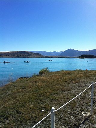
Lake Ruataniwha is an artificial lake in the Mackenzie Basin in the South Island of New Zealand. It was formed in 1977–1981 as part of the Waitaki hydroelectric project. It lies on the traditional boundary of the Canterbury and Otago provinces, with the town of Twizel two kilometres to the north.
Lake Ōhau is a lake in the Mackenzie Basin in the South Island of New Zealand. The Hopkins and Dobson rivers fed into the northern end of Lake Ōhau. These rivers have their headwaters in the Southern Alps. The lake's outflow is the Ōhau River, which travels from the southeast corner of Lake Ōhau and feeds into the Waitaki River hydroelectric project. The Barrier range dominate the western side of Lake Ōhau, while the Ben Ohau range dominates the eastern side of Lake Ōhau. At the northern end of the lake, in between the Hopkins and Dobson rivers, lies the Naumann Range of mountains.
Lake Pukaki is the largest of three roughly parallel alpine lakes running north–south along the northern edge of the Mackenzie Basin on New Zealand's South Island. The others are Lakes Tekapo and Ōhau. All three lakes were formed when the terminal moraines of receding glaciers blocked their respective valleys, forming moraine-dammed lakes. The Alps2Ocean mountain bike trail follows the edge of Lake Pukaki for part of its length.
Lake Tekapo is the second-largest of three roughly parallel lakes running north–south along the northern edge of the Mackenzie Basin in the South Island of New Zealand. It covers an area of 83 km2 (32 sq mi) and is at an altitude of 710 m (2,330 ft) above sea level.
Lake Tekapo is a small township located at the southern end of the lake of the same name in the inland South Island of New Zealand. It had 558 residents according to the 2018 census, being one of five settlements in the sparsely populated Mackenzie Basin.
The Pukaki River flows through the Mackenzie Basin, Canterbury, in New Zealand's South Island.
Mackenzie District is a local government district on New Zealand's South Island, administered by the Mackenzie District Council. It is part of the larger Canterbury Region. The region takes its name from the Mackenzie Basin, an elliptical intermontane basin which covers much of inland Canterbury.
The black stilt or kakī (Māori) is a wading bird found in New Zealand. It is one of the world's rarest birds, with 169 adults surviving in the wild as of May 2020. Adult kakī have distinctive black plumage, long pink legs, and a long thin black bill. Black stilts largely breed in the Mackenzie Basin in the South Island, and are threatened by introduced feral cats, ferrets, and hedgehogs as well as habitat degradation from hydroelectric dams, agriculture, and invasive weeds.
South Canterbury is the area of the Canterbury Region of the South Island of New Zealand bounded by the Rangitata River in the north and the Waitaki River to the south. The Pacific Ocean and ridge of the Southern Alps form natural boundaries to the east and west respectively. Though the exact boundaries of the region have never been formalised, the term is used for a variety of government agencies and other entities. It is one of four traditional sub-regions of Canterbury, along with Mid Canterbury, North Canterbury, and Christchurch city.
State Highway 8 is one of New Zealand's eight national highways. It forms an anticlockwise loop through the southern scenic regions of the Mackenzie Basin and Central Otago, starting and terminating in junctions with State Highway 1. Distances are measured from north to south.
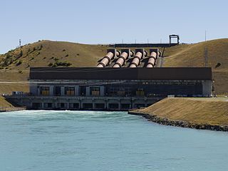
Ōhau A is a power station operated by Meridian Energy in the South Island of New Zealand.
The Alps 2 Ocean Cycle Trail is a cycle trail in the South Island of New Zealand. This trail is one of the projects of the New Zealand Cycle Trail project. The trail extends more than 300 km (190 mi) from Aoraki / Mount Cook to Oamaru on the Pacific Ocean. From west to east, it descends from an altitude of 780 metres (2,560 ft) down to sea level. The trail has both on and off-road sections.
The Ōhau River is a river in the Mackenzie Basin of New Zealand's South Island. It is the primary outflow of Lake Ōhau, from which it flows in a roughly eastward direction until reaching the artificial Lake Benmore after a distance of roughly 27 kilometres (17 mi). In 1981, the artificial Lake Ruataniwha was created along the river's length to power a small hydroelectric power station as part of the Waitaki hydro scheme. Prior to the creation of the Waitaki hydro scheme, the river flowed directly into the Waitaki River rather than through a series of lakes. The river forms part of the traditional boundary between Otago and Canterbury regions.
The Aoraki Mackenzie International Dark Sky Reserve is an area of 4,367 km2 (1,686 sq mi) that was designated as an International Dark Sky Reserve by the International Dark-Sky Association in June 2012. The reserve is located in the Mackenzie District in the South Island of New Zealand. At the time of the designation in 2012, the reserve was the largest in the world, and the only reserve of its type in the Southern Hemisphere.
The Tekapo A Power Station is a hydroelectric facility at the southern end of Lake Tekapo in the Mackenzie Basin, Canterbury, New Zealand. It is a short distance south of the township. The power station is owned and operated by Genesis Energy Limited.