Skippers Canyon is a historic and scenic gorge, some 22 kilometres in length, several kilometres north of Queenstown, New Zealand.
Today accessed from Queenstown via the same road that leads to the Coronet Peak skifield, Skippers Canyon is carved out by the Shotover River. The Shotover, one of New Zealand's richest gold-bearing rivers, was named by William Gilbert Rees who with his wife Frances and brother-in-law Nicholas von Tunzelmann were the first European settlers in and near where Queenstown is now.
Once a busy goldmining area, Skippers Canyon was accessed by Skippers Road, which is today one of New Zealand's better known scenic roads.
The main New Zealand road where rental car insurance is not honoured, Skippers Road is mostly one-lane, narrow and steep with sheer drops of several hundred metres. In 1886, Skippers Canyon was also the first site where hydroelectricity was generated to power goldmining. [1]
In November 1862, Thomas Arthur and Harry Redfern discovered in the area of today's Arthurs Point about 4 ounces of gold within 3 hours. [2] Arthur and Redfern made no secret of their gold discoveries. With such richness in sight, it was no wonder that the area was soon swarmed by miners trying to find their luck. This was the beginning of one of the largest rushes that occurred in Otago. [2] Soon after the start of the gold rush, the miners referred to the Shotover River as the 'richest river in the world'. There is however no proof available that this is true as no official records were kept about how much gold was actually found. [3]
Charlestown was a little settlement in Skippers Canyon. After the first gold was found, gold miners soon encountered the gorge behind Arthurs Point by following 'the golden river' [4] upstream. They had to find their own way over the trackless hills as the river was deep and swift. For much of its course, it is confined in steep-walled gorges. Undaunted by the difficulties, miners climbed the mountains and descended to the beaches wherever possible. [4] Soon a remarkable discovery of gold was found at Māori Point (as it became known). [5] Two Māori miners, Dan Ellison (Raniera Erihana) and Hakaria Maeroa travelled to a secluded gorge in Skippers Canyon. They could see on the opposite shore some promising appearances and boldly tried to cross the river. One of their dogs followed them and was washed away. Dan Ellison went to its assistance and could rescue the dog. At shore, he observed some particles of gold in the crevices of the rocks and started to examine the sandy beach beneath. With the aid of Hakaria, they gathered 25 pounds (or 300 ounces) of precious metal before nightfall. [5]
This substantial find formed the birth hour of Charlestown. It was built on the flat land of Māori Point. [5] Soon hotels were established, butchers, bakers, a post office and a bank settled at Charlestown. There was even a police station and a resident magistrate who was appointed to settle claim disputes on location. Charlestown boomed shortly, peaking with a population of about 1,000 people. But by 1864 the easily gained gold had been won and the population dropped to about 400 people. [5] Today, only very little remains of Charlestown in Skippers Canyon: stones of a fallen chimney, a small plaque and an explanation booth mark the area.
The canyon and Skippers Point were named after 'Skipper' Malcolm Duncan, who discovered gold in the canyon in 1862. [5] Born in Northern Ireland, Duncan served for a number of years on American ships, hence the nickname 'Skipper'. Duncan took part in the gold rush and discovered gold at Skippers Creek, which soon became known as Skippers Point or simply 'Skippers'. [5]
In 1866, a novel hydroelectric station was built at Dynamo, in the left branch of Skippers Creek. The station sent power 3 km over the hill to Bullendale, a small goldmining settlement some 4 hours walk from the farthest end of Skippers Road, where it powered an aircompressor to run a stamping plant to separate gold from quartz. The plant was not profitable. [1]
Next to Duncan, several other gold miners took claims in the area of Skippers Point where they remained working on them until the early 1900s. [5] The remains of their water races, holding dams, sluicings and tailings of the established claims are still obvious today. A huge sluiced basin of the Skippers Sluicing Company's claim, right below Mount Aurum Station's Homestead and Skippers School, is very much visible today, even though it is completely covered by trees. Like Charlestown, Skippers Point had an initial population of about 1,000 people but stabilised to about 200 around 1864. [5] At one stage, there were six hotels at Skippers Point, but like Charlestown, their life was short.
Today, only the remains of Mount Aurum Station's Homestead and the restored Skippers School as well as the cemetery are visible. Mount Aurum Station's Homestead burned down in 2018. [6] The cemetery contains some interesting headstones. Of more recent times is the delightful inscription on the grave of Lorraine Borrell: "my time is up, I’ve been clocked out. The judge has tapped the gavel. I’ll retire the teapot, lay the knitting down and quietly unravel." [5]
At the beginning of the gold rush, no track or road was present in Skippers Canyon. As the gold miners travelled through the canyon with their horses, tracks were formed. They were rough and steep but established ways to Deep Creek, Māori Point and Skippers were in use in 1863. [4] Those tracks however were unsafe and those who tried to take packhorses sometimes lost them and their supplies.
In order to make the access to Skippers safer and to be able to bring in heavy machinery for the gold miners, the demand for a proper road grew. Skippers Road was surveyed at about 1883 [4] with the goal to make Skippers Canyon more accessible. The road was built by 4 contractors who completed their work in stages over the period of seven years. [5] Many sections of the road remain today very much as they were in 1890.
It has been said of Skippers Road that more money has been spent on its account than all the gold could repay it. [4] This comment, however only meant figuratively, nicely explains the enormous costs and difficulty involved not only in forming the road but also in maintaining it. The local rock is so soft that under the traffic it quickly turns into dust in dry weather and to greasy mud in wet. Under these conditions it is no surprise to learn that initially motor vehicles were banned from driving on Skippers Road at the beginning of the 1900s. [4]
By the time of its completion the gold rush was basically over, but some future-oriented people of the Queenstown district saw potential in the use of Skippers Road as a tourist attraction. Petitions supporting the plan that cars could be used to travel on Skippers Road as well as petitions to ban them were signed. The community was split in two groups as a result. [7] The court ruled that Skippers Road could be used by cars, but drivers were obliged to give plenty of warning of their travel plans by applying for a permit. [7] Even time limits of usage were defined. A fine of ten dollars was the penalty if those regulations were disregarded. [7]
Today, Skippers Road is a tourist attraction. It is protected by Heritage New Zealand since 15 December 2006 under the register number 7684. [8]
The first bridge that enabled the gold miners to safely reach Skippers Point was a suspension structure. Building of this bridge began as early as 1866. [4] It crossed the river only 6 metres above the water and was prone to damage from flooding. It was replaced in 1871 but rebuilt at the same place. The access to this first crossing of the Shotover River was difficult as the approaches to it were very steep on both sides. [5] At the time the new road to Skippers Point was completed, plans for a new higher bridge were made. Work on this new bridge began in 1898 [5] and lasted for about 2 years. [4] In March 1901, the bridge was officially opened by the Minister of Mines [5] and finally replaced the old one. The stone approaches of the old bridge still stand and are visible from Skippers Road.
Even though the completion of the existing Skippers Bridge was done after the gold rush was over, it is today one of the major attractions for visitors to Skippers Canyon as it spans a gorge with sheer rock faces on both sides and is about 100 metres above the river.
Queenstown is a resort town in Otago in the south-west of New Zealand's South Island. It is the seat and largest town in the Queenstown-Lakes District.
The Clutha River is the second longest river in New Zealand and the longest in the South Island. It flows south-southeast 338 kilometres (210 mi) through Central and South Otago from Lake Wānaka in the Southern Alps to the Pacific Ocean, 75 kilometres (47 mi) south west of Dunedin. Gold is in abundance in the Clutha River and its surrounding areas. It is the highest volume river in New Zealand, and has a discharging mean flow of 614 cubic metres per second (21,700 cu ft/s).
Arrowtown is a historic gold mining town in the Otago region of the South Island of New Zealand. Arrowtown is located on the banks of the Arrow River approximately 7.5 km from State Highway 6. Arrowtown is located 19.5 kilometres to the east of Queenstown. As well as the route via State Highway 6 at Arrow Junction, there is also road access directly to Queenstown via Arthurs Point and a third route via the picturesque Lake Hayes.
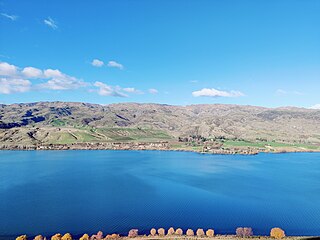
Cromwell is a town in Central Otago region of the South Island of New Zealand. Cromwell is located on the shores of Lake Dunstan where the Kawarau river joins Lake Dunstan. Cromwell was established during the Otago gold rush and is now more known as one of the sub regions of the Central Otago wine region. In 2018, the town of Cromwell was home to a population of 5610 people.
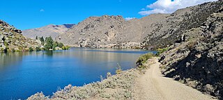
The Kawarau River is a river in the South Island of New Zealand. It drains Lake Wakatipu in northwestern Otago via the lake's Frankton Arm. The river flows generally eastwards for about 60 kilometres (37 mi) and passes through the steep Kawarau Gorge until it joins Lake Dunstan near Cromwell. Before the construction of the Clyde High Dam, the Kawarau joined the Clutha River / Mata-Au in a spectacular confluence at Cromwell. The Shotover River enters the Kawarau from the north; the Nevis River enters it from the south. With many rapids and strong currents, the river can be dangerous and has claimed many lives. It is popular for bungy jumping and kayaking.
The Shotover River is located in the Otago region of the South Island of New Zealand. The name correctly suggests that this 75-kilometre (47 mi) long river is fast flowing, with numerous rapids. The river flows generally south from the Southern Alps on its journey running through the Skippers Canyon, draining the area between the Richardson Mountains and the Harris Mountains, before flowing into the Kawarau River east of Queenstown.
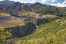
The Cromwell Gorge is a steep gorge cut by the former Clutha River in the Central Otago region of New Zealand's South Island. It winds 19 km (12 mi) between the Dunstan and Cairnmuir Mountains, linking the townships of Cromwell and Clyde. It is one of three substantial river gorges in Central Otago, the others being the Kawarau Gorge to the west of Cromwell, and the Roxburgh Gorge south of Alexandra.
The Otago gold rush was a gold rush that occurred during the 1860s in Central Otago, New Zealand. This was the country's biggest gold strike, and led to a rapid influx of foreign miners to the area – many of them veterans of other hunts for the precious metal in California and Victoria, Australia. The number of miners reached its maximum of 18,000 in February 1864.
State Highway 8 is one of New Zealand's eight national highways. It forms an anticlockwise loop through the southern scenic regions of the Mackenzie Basin and Central Otago, starting and terminating in junctions with State Highway 1. Distances are measured from north to south.
The Kawarau Gorge is a major river gorge created by the Kawarau River in Central Otago, in the South Island of New Zealand. The towns of Queenstown and Cromwell are linked by State Highway 6 through the gorge.
Eichardt‘s Private Hotel is located on the corner of Marine Parade and Ballarat Street, Queenstown, New Zealand, on the shores of Lake Wakatipu. Eichardt’s is a significant local landmark, and is listed as a Category Two historic place by the Historic Places Trust.
Choie Sew Hoy also known as Charles Sew Hoy was a New Zealand merchant, Chinese leader, gold-dredger and a New Zealand Business Hall of Fame laureate. He was born in the village of Sha Kong in the Poon Yu District of Guangdong Province, China in about 1838.
Horatio Hartley (1826–1903) was an American gold prospector who participated in the Otago gold rush in New Zealand in the 1860s.
Queenstown Police Station is the largest police station in the Otago Lakes Central Area which is one of three policing areas in the Southern District of the New Zealand Police. The Otago Lakes Central Area headquarters has returned to Queenstown Police Station after a period at Alexandra Police Station. The area of responsibility covered by the Queenstown Police extends from Kingston in the south, to the Crown Range summit in the north, and from Glenorchy and its environs in the west, to the Roaring Meg power station in the Kawarau Gorge in the east.
Edith Cavell Bridge is a bridge over the Shotover River in the Otago region in the South Island of New Zealand that stands at 47.8 metres (157 ft) tall. It is registered by Heritage New Zealand as a Category I heritage structure.
The Queenstown Trail is a cycle and walking trail funded as one of the projects of the New Zealand Cycle Trail (NZCT) system in Otago, New Zealand. It links the towns of Queenstown, Arrowtown, the suburb of Jack's Point and the area of Gibbston. It is at least 110 km in length but is not linear and instead follows the terrain often near rivers and lakes to link key places in a series of tracks that also access public land. In some places it also passes through private land such as working farms and users are encouraged to stay on the trail. The trail is a joint venture between the Government, Queenstown Lakes District Council and the Queenstown Trails Trust.
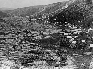
The blizzard and flood of 1863 was a series of consecutive natural disasters in Central Otago in New Zealand's South Island. In the early 1860s the area was in the midst of a gold rush. From July to August 1863 the gold fields suffered from a combination of floods, snowstorms, and blizzards that caused heavy loss of life among the gold miners. At least 40 died during the July rains and more than 11 in the August snows. Sources using the earliest reports of loss of life tend to greatly overstate the numbers who died.
The Bendigo Goldfields region of Central Otago is an historic area comprising several former mining settlements in the southern South Island of New Zealand. It was part of the Otago gold rush that occurred during the 1860s, leading to an influx of miners from rushes in California and Victoria, Australia. These miners brought with them a rich diversity of cultures from England, Scotland, Wales, Ireland, Sweden, China, Australia, Canada, and the United States. The area was named after the goldfield by the same name in Victoria.
The Dunstan Mountains are a mountain range in Central Otago, in the South Island of New Zealand. The mountains lie on the eastern shore of the man-made Lake Dunstan and overlook the towns of Cromwell to the west, Clyde to the south and Omakau to the east. The highest named peak on the mountain range, a rocky knoll simply called Dunstan, is 1,667 m.
Christopher Reilly was an Irish gold prospector who participated in the Otago gold rush in New Zealand in the 1860s.
Illustrated History of Central Otago & the Queenstown Lakes District by Gerald Garrick Cunningham (2005, Reed Publishing, Auckland).