
Mount Ruapehu is an active stratovolcano at the southern end of the Taupō Volcanic Zone and North Island volcanic plateau in New Zealand. It is 23 km (14 mi) northeast of Ohakune and 23 km (14 mi) southwest of the southern shore of Lake Taupō, within the Tongariro National Park. The North Island's major ski resorts and only glaciers are on its slopes.

The Tangiwai disaster was a deadly railway accident that occurred at 10:21 p.m. on 24 December 1953, when a railway bridge over the Whangaehu River collapsed beneath an express passenger train at Tangiwai, North Island, New Zealand. The locomotive and the first six carriages derailed into the river, killing 151 people. The subsequent board of inquiry found that the accident was caused by the failure of the tephra dam holding back nearby Mount Ruapehu's crater lake, creating a rapid mudflow (lahar) in the Whangaehu River which destroyed one of the bridge piers at Tangiwai only minutes before the train reached the bridge. The volcano at Mount Ruapehu was not erupting at the time. The disaster remains New Zealand's worst rail accident.

Mount Taranaki is a dormant stratovolcano in the Taranaki region on the west coast of New Zealand's North Island. At 2,518 metres (8,261 ft), it is the second highest mountain in the North Island, after Mount Ruapehu. It has a secondary cone, Fanthams Peak, 1,966 metres (6,450 ft), on its south side.

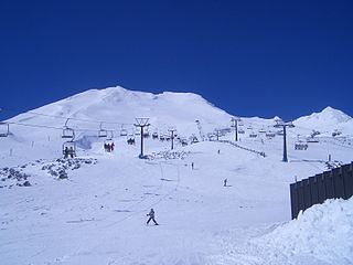
Whakapapa skifield is a commercial skifield on the northern side of Mount Ruapehu in Tongariro National Park, New Zealand. It is one of three skifields on the mountain, the others being Turoa, which is on Ruapehu's south-western slopes and Tukino on the eastern slopes. The ski season is generally from late June to late October, depending on snow and weather conditions. The terrain at Whakapapa Skifield is divided up as 25% beginner, 50% intermediate and 25% advanced.
Tongariro National Park, located in the central North Island, is the oldest national park in New Zealand and the sixth national park established in the world. It has been recognised by UNESCO as a World Heritage Site for its mixed cultural and natural values.

Ohakune is a small town at the southern end of Tongariro National Park, close to the southwestern slopes of the active volcano Mount Ruapehu, in the North Island of New Zealand.
Turoa is a skifield on the south western side of Mount Ruapehu, the highest mountain in the North Island of New Zealand, in Tongariro National Park. The area has been used for skiing since before the completion of the Mountain Road; however, the first lifts opened in 1978. Turoa was owned by Ruapehu Alpine Lifts from 2000, a company that also owned the nearby Whakapapa skifield, also on Mt. Ruapehu. After liquidation of Ruapehu Alpine Lifts in 2023, the field was purchased by Pure Turoa. The field has been operated by Pure Turoa since April 2024.
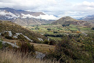
The Crown Range is a mountain range that lies to the east of the Wakatipu Basin in Otago, New Zealand. It is noted for two features, the Cardrona Alpine Resort, on the slopes of the 1900 metre Mount Cardrona, and a highway, known as the Crown Range Road, which winds steeply between Arrow Junction, just south of Arrowtown, and Wānaka to the north.

The North Island Volcanic Plateau is a volcanic plateau covering much of central North Island of New Zealand with volcanoes, lava plateaus, and crater lakes. It contains the Taupō caldera complex, Ōkataina caldera complex and Tongariro Volcanic Centre resulting in it being currently the most frequently active and productive area of silicic volcanism on Earth. New Zealand is part of the Pacific Ring of Fire.

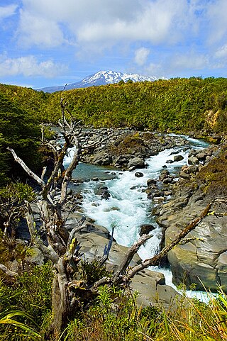
The Whakapapa River in New Zealand forms from streams which trickle off the Whakapapa skifield of Mount Ruapehu and down the western slopes of the mountain. The river passes near Ōwhango, before finally merging with the Whanganui River just east of Kakahi, about 40 km (25 mi) from where it starts, which is in a 100 m (330 ft) deep gorge, at the confluence of the Whakapapaiti and Whakapapanui Streams.
Ngāti Apa is a Māori iwi (tribe) in Rangitikei District of New Zealand. Its rohe extend between the Mangawhero, Whangaehu, Turakina and Rangitīkei rivers. This area is bounded by Whanganui River in the north-west, and Manawatū River in the south-east. The marae in this district include Tini wai tara, Whangaehu, Kauangaroa, and Parewanui.
Mangamahu is a hill-country farming and forestry community in the middle reaches of the Whangaehu River valley, in the Whanganui District and Rangitikei District of Manawatū-Whanganui, New Zealand. It is centred on the village of Mangamahu, which is situated on river flats where the Mangamahu stream flows into the Whangaehu river. Mangamahu has a primary school which has been open since 1894 and a War Memorial Hall built in 1952.
State Highway 49 (SH 49) is a New Zealand state highway, linking SH 4 and SH 1, via the tourist town of Ohakune. It forms the southern part of the ring road surrounding Tongariro National Park and provides access to the southern side of Mount Ruapehu and the Turoa skifield. It roughly follows the North Island Main Trunk railway.

Ngāti Rangi or Ngāti Rangituhia is a Māori iwi (tribe) of New Zealand. Contemporary settlement is mainly around Waiouru, Ohakune, and the Upper Whanganui River in the central North Island. The iwi's area of interest extends north from the Paretetaitonga peak of Mount Ruapehu, west to the Pukupuku Stream, east to the meeting of the Moawhango and Aorangi waterways, and south to the Haumakariri Stream. Ngāti Rangi trace their ancestry to Paerangi. They believe they were in New Zealand before the first migrations from Hawaiki.

The Tongariro Power Scheme is a 360 MW hydroelectricity scheme in the central North Island of New Zealand. The scheme diverts water from tributaries of the Rangitikei, Whangaehu, Whanganui, and Tongariro rivers. These rivers drain a 2,600-square-kilometre (1,000 sq mi) area including Ruapehu, Ngauruhoe, Tongariro and the western Kaimanawa Ranges. The water diverted from these rivers is sent through canals and tunnels to generate electricity at three hydro power stations, Rangipo (120 MW), Tokaanu (240 MW) and Mangaio (2 MW). The water is then discharged into Lake Taupō where it adds to the water storage in the lake and enables additional electricity generation in the succession of power stations down the Waikato River.

The Makotuku River is a river of the west of New Zealand's North Island. It flows southwest from Tūroa ski field, on the slopes of Mount Ruapehu, and passes through the town of Raetihi before its confluence with the Mangawhero River. It has been affected by several lahars over the last 160,000 years.

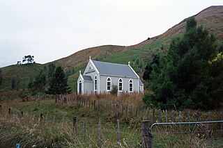
Rangataua is a small village in the North Island of New Zealand. It is located at the southern end of both the Tongariro National Park and Rangataua State Forest, adjacent to the southwestern slopes of the active volcano Mount Ruapehu. Part of the Manawatū-Whanganui region, the town is 5 kilometres east of Ohakune, 75 kilometres northeast of Wanganui, and 20 kilometres west of Waiouru.

Whangaehu is a settlement in the Rangitikei District and Manawatū-Whanganui region of New Zealand's North Island.
The seismically active southern end of the Taupō Rift beyond Mount Ruapehu has a number of mainly east to west orientated termination faults where the western wall Raurimu Fault and eastern wall Rangipo Fault terminate in the Ruapehu Graben, of the central North Island of New Zealand. In a multi-fault rupture event there is the potential for the earthquake being of 7.1 magnitude.

The Ohakune volcanic complex is a small extinct monogenetic volcano south-west of Mount Ruapehu and just north of the town of Ohakune in Manawatū-Whanganui, New Zealand. It is in the area of the southernmost volcanic activity in the Taupō Rift and located adjacent to the potentially active Ohakune Fault.

