
Waikato is a region of the upper North Island of New Zealand. It covers the Waikato District, Waipa District, Matamata-Piako District, South Waikato District and Hamilton City, as well as Hauraki, Coromandel Peninsula, the northern King Country, much of the Taupō District, and parts of the Rotorua Lakes District. It is governed by the Waikato Regional Council.
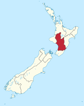
Manawatū-Whanganui is a region in the lower half of the North Island of New Zealand, whose main population centres are the cities of Palmerston North and Whanganui. It is administered by the Manawatū-Whanganui Regional Council, which operates under the name Horizons Regional Council.
Tangiwai is a 2,696.66 km2 (1,041.19 sq mi) census area and a small rural community in the Ruapehu District of the Manawatū-Whanganui region of New Zealand's North Island. It is located east of Ohakune and Rangataua and west of Waiouru on State Highway 49. In 2018 37.5% of the area's 1,281 residents worked in agriculture, forestry and fishing and 7.1% in manufacturing.
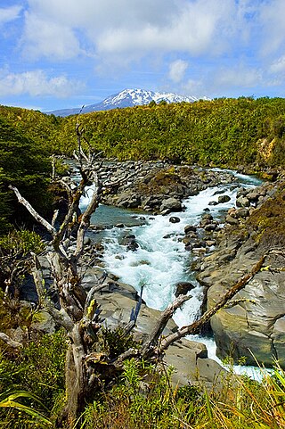
Tongariro National Park is the oldest national park in New Zealand, located in the central North Island. It has been acknowledged by UNESCO as a World Heritage Site of mixed cultural and natural values.

Ohakune is a small town at the southern end of Tongariro National Park, close to the southwestern slopes of the active volcano Mount Ruapehu, in the North Island of New Zealand.
Maungatua, known also as Maukaatua is a prominent ridge in the Taieri Plains in Otago, New Zealand.
The King Country is a region of the western North Island of New Zealand. It extends approximately from Kawhia Harbour and the town of Ōtorohanga in the north to the upper reaches of the Whanganui River in the south, and from the Hauhungaroa and Rangitoto Ranges in the east to near the Tasman Sea in the west. It comprises hill country, large parts of which are forested.

The Whanganui River is a major river in the North Island of New Zealand. It is the country's third-longest river, and has special status owing to its importance to the region's Māori people. In March 2017 it became the world's second natural resource to be given its own legal identity, with the rights, duties and liabilities of a legal person. The Whanganui Treaty settlement brought the longest-running litigation in New Zealand history to an end.

Ōwhango is a small town in New Zealand situated about 20 kilometres (12 mi) south of Taumarunui on State Highway 4 (SH4), and about 2 kilometres (1.2 mi) west of the Whakapapa River, a tributary of the nascent Whanganui River.

The Retaruke River is a river in the North Island of New Zealand. It joins with the Whanganui River at Whakahoro just above Wade's Landing and downstream from Taumarunui. The river flows through the farming communities of Upper and then Lower Retaruke Valley. Downstream from this junction is the Mangapurua Landing with its Bridge to Nowhere, servicing the ill-fated Mangapurua Valley farming community.

Rangataua is a small village in the North Island of New Zealand. It is located at the southern end of both the Tongariro National Park and Rangataua State Forest, adjacent to the southwestern slopes of the active volcano Mount Ruapehu. Part of the Manawatū-Whanganui region, the town is 5 kilometres east of Ohakune, 75 kilometres northeast of Wanganui, and 20 kilometres west of Waiouru.

Ranana is a settlement 60 kilometres (37 mi) up the Whanganui River from Whanganui, New Zealand.

The Makatote Viaduct takes the North Island Main Trunk railway (NIMT) across the Makatote River in New Zealand. It is 335.7 km (208.6 mi) from Wellington, at the foot of Ruapehu, in northern Manawatū-Whanganui, between Erua and Pokaka.
Waimiha is a rural community in the Ruapehu District and Manawatū-Whanganui region of New Zealand's North Island.

Ongarue is a rural community in the Ruapehu District and Manawatū-Whanganui region of New Zealand's North Island. It is located south of Te Kūiti and Waimiha, and north of Taumarunui. It is in meshblock 1041902, which had a population of 54 in 2013.
Akatarawa Forest is a regional park in the Upper Hutt within the Wellington Region at the southern tip of the North Island of New Zealand. It encompasses 15,000 hectares of native and plantation forest. It includes the headwaters of the Maungakotukutuku Steam, Akatarawa River West and the Whakatīkei River.

Whangaehu is a settlement in the Rangitikei District and Manawatū-Whanganui region of New Zealand's North Island.
Kaitieke or Kaitīeke is a rural community, located south of Taumarunui and 13 kilometres (8.1 mi) west of Raurimu, in the Ruapehu District and Manawatū-Whanganui region of New Zealand's North Island.

Erua was a station on the North Island Main Trunk line, in the Ruapehu District of New Zealand. It served the small village of Erua. For a month in 1908 it was the terminus of the line from Auckland. Makatote Viaduct and tramway are about 3 mi (4.8 km) south of Erua.

A sanctuary area is a type of New Zealand protected area. They exist to preserve populations of important forest types, like the remnants of kauri forests in Northland.
