The Wai-iti River is in the north of the South Island of New Zealand. It flows northeast for 45 kilometres (28 mi) before combining with the Wairoa River to form the Waimea River. This flows into the southern end of Tasman Bay / Te Tai-o-Aorere near Richmond.

The Whanganui River is a major river in the North Island of New Zealand. It is the country's third-longest river, and has special status owing to its importance to the region's Māori people. In March 2017 it became the world's second natural resource to be given its own legal identity, with the rights, duties and liabilities of a legal person. The Whanganui Treaty settlement brought the longest-running litigation in New Zealand history to an end.
Kaimata is a locality in Taranaki, New Zealand. Inglewood is about 7.5 km to the west. The Manganui River flows past to the west. Kaimata was one of many townships established to service the dairy industry.

Ngāti Rangi or Ngāti Rangituhia is a Māori iwi (tribe) of New Zealand. Contemporary settlement is mainly around Waiouru, Ohakune, and the Upper Whanganui River in the central North Island. The iwi's area of interest extends north from the Paretetaitonga peak of Mount Ruapehu, west to the Pukupuku Stream, east to the meeting of the Moawhango and Aorangi waterways, and south to the Haumakariri Stream. Ngāti Rangi trace their ancestry to Paerangi. They believe they were in New Zealand before the first migrations from Hawaiki.
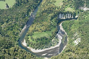
The Makatote River is a river of the centre of New Zealand's North Island. It flows west from the slopes of Mount Ruapehu, and from the Hauhungatahi Wilderness Area, before entering rough hill country, veering southwest and entering a gorge cut almost 100 m (330 ft) into the volcanic rocks. It joins with the waters of several smaller streams to become the Manganui o te Ao River, part of the Whanganui River system.
The Mangamaire River is a river of the centre of New Zealand's North Island. One of the headwaters of the Rangitikei River system, it flows generally southwest from its origins southeast of Lake Taupō, forming part of the border of the Kaimanawa Forest Park for much of its length. It meets the young Rangitikei in hill country 40 kilometres (25 mi) east of Mount Ruapehu.
For the sawmill area of Mangapehi see Ellis and Burnand#Mangapehi

The Mangatāwhiri River is a river of the Waikato region of New Zealand's North Island. It flows generally southwest from its sources in the Hunua Ranges southeast of Clevedon before flowing through a system of irrigation canals at the northern edge of the Waikato Plains close to the town of Pōkeno. It reaches the Waikato River close to the township of Mercer.

The Mangaturuturu River is a river at the centre of New Zealand's North Island. One of the headwaters of the Manganui o te Ao River, it flows west from the slopes of Mount Ruapehu, joining with numerous other small rivers to become the Manganui o Te Ao 20 kilometres (12 mi) northwest of Ohakune. It has also been known as Sulphur River, or Sulphur Creek. In April 1975 a lahar raised the river to 2.1 m above its flood level. There were also lahars in 1969 and September 1995. Earlier lahars were around 8,500 and 10,500 years ago.

The Ōhikaiti River is a river of the West Coast Region of New Zealand's South Island. It flows north from Mount Galileo, in the Paparoa Range, paralleling the course of the larger Ōhikanui River which lies two kilometres to the west. The Ōhikaiti empties into the Buller River at the Buller Gorge, 15 kilometres southwest of Westport.
The Omaru River is a river of the Northland Region of New Zealand's North Island. It flows generally north from several streams with origins northwest of Paparoa, reaching the Manganui River 20 kilometres northeast of Ruawai.
The Otahu River is a river of the Coromandel Peninsula, in the Waikato Region of New Zealand's North Island. It flows generally northeast from several streams with watersheds in the Coromandel Range, most notably the Wharekirauponga Stream. The Otahu reaches the sea immediately to the south of the town of Whangamatā.
The Owahanga River is a river in the Tararua District, in the Manawatū-Whanganui Region of New Zealand's North Island. Its tortuous course winds generally southeast through rough hill country, reaching the sea 30 km (19 mi) southwest of Cape Turnagain.
The Waihora River is a river of the Gisborne Region of New Zealand's North Island. It flows generally west from its sources in rough hill country southwest of Tolaga Bay to reach the Waipaoa River at Te Karaka.

The Waikōau River is a river in southern Fiordland, New Zealand. Since 21 June 2019 the official name has been Waikōau River. Waikōau River North Branch has been the official name of a tributary, which joins the river about a kilometre from the sea, since 19 December 2019. Rising north of the Hump Ridge, it flows south-eastward into Te Waewae Bay.
The Waiaua River is a river of the Bay of Plenty Region of New Zealand's North Island. It flows generally northwest to reach the eastern end of the Bay of Plenty 10 kilometres (6 mi) east of Ōpōtiki.

The Waiaua River is a river of the Taranaki Region of New Zealand's North Island. It flows southwest from the slopes of Mount Taranaki to reach the Tasman Sea at Ōpunake.
Te Korowai o Wainuiārua is a grouping of Māori hapū in the northern Manawatū-Whanganui region of New Zealand. It was formed in 2014 to represent the large natural group of the middle Whanganui River area. It is made up of the Tamahaki, Tamakana and Uenuku ki Manganui-a-te-Ao, nā Tukaihoro hapū. Its area of interest covers some 6,130 km2 (2,370 sq mi), including central and upper parts of the Whanganui River, Whanganui National Park, Tongariro National Park, Raetihi and National Park. A Treaty settlement signed at Raetihi Marae on 29 July 2023 included an apology, $28.5m of compensation, return of forestry land at Erua, the former Waikune prison, support to create a predator-proofed sanctuary at Pōkākā and a seat on Tongariro-Taupō Conservation Board.

Putiki is a settlement in the Whanganui District and Manawatū-Whanganui region of New Zealand's North Island, located across the Whanganui River from Whanganui city. It includes the intersection of State Highway 3 and State Highway 4.
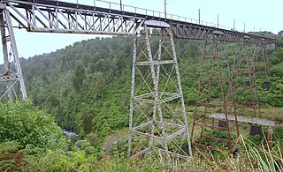
Pokaka was a station on the North Island Main Trunk line, in the Ruapehu District of New Zealand. It served the small village of Pokaka and lay to the south of Makatote Viaduct, the late completion of which held up opening of the station.