Retaruke River

Last updated

Retaruke River
Retaruke River from Whakahoro Bridge.jpg
The Retaruke River from Lacy's Bridge in Whakahoro
Retaruke River
Native nameRetaruke (Māori)
Location
Country New Zealand
Region Manawatū-Whanganui
District Ruapehu
Settlements Kaitieke, Whakahoro
Physical characteristics
Source Erua Forest
  location2km south west of National Park
  coordinates 39°10′59″S175°22′52″E / 39.18306°S 175.38111°E / -39.18306; 175.38111
  elevation870 m (2,850 ft)
Mouth Whanganui River
  location
Whakahoro
  coordinates
39°6′29″S175°4′12″E / 39.10806°S 175.07000°E / -39.10806; 175.07000
  elevation
110 m (360 ft)
Length64 km (40 mi)
Basin features
ProgressionRetaruke RiverWhanganui River
River system Whanganui River

The Retaruke River is a river in the North Island of New Zealand. It joins with the Whanganui River at Whakahoro just above Wade's Landing and downstream from Taumarunui. The river flows through the farming communities of Upper and then Lower Retaruke Valley. Downstream from this junction is the Mangapurua Landing with its Bridge to Nowhere, servicing the ill-fated Mangapurua Valley farming community.

Contents

Sources

The river source is located 2 km (1.2 mi) south west of National Park in the Erua Forest. The river initially flows south west through the forest before bending to flow north west. [1]

Retaruke River gorge at Ngamoturiki Retaruke River gorge at Ngamoturiki.jpg
Retaruke River gorge at Ngamoturiki

Geology

Most of the valley is made up of Early Miocene Mahoenui Group rocks. About 65,000 years ago movement of the Waimarino Fault probably allowed capture of the Waimarino Stream and/or Makatote River by the Manganuiateao River, which would have reduced erosion by ending the incidence of lahars and reducing flows in the Retaruke River. [2]

Coal was discovered in 1909 [3] in the Late Miocene Whangamomona Group. During the 1960s [4] and 1970s, an opencast coal mine operated at the top end of Retaruke Road. [5] Between 1938 and 1984 it produced about 3,000 tons of coal. [6]

Upper Retaruke valley community

1 kilometre up the Upper Retaruke Valley road is the location of the annual Kaitieke Collie club sheepdog trials. Next is the location of a "Victory Hall". Further up the valley there was a coal mine, and it was along the upper Retaruke river that fossil whalebones were found by Ken McNaught.[ citation needed ]

Kaitieke County

The Retaruke valley is contained within the original Kaitieke County.

This county was created by the Kaitieke County Act 1910 [7] from portions of Waimarino and West Taupo Counties. Its eastern boundary was the Main Trunk line from Erua to Taumarunui, and its western boundary was the Whanganui River down to Te Auroa, about 7 km (4.3 mi) east of Waitotara. Other settlements in the county included Manunui, Raurimu, Ōwhango, Kakahi, and Piriaka. [8] Manunui Town Board was split from the county in 1911 [9] and the county became part of Taumarunui County in 1956. [10]

The Kaitieke Council Chambers were located at Raurimu near the old Raurimu District High School.

The Kaitieke County stockyards are located at the junction of the Upper and Lower Retaruke Roads 39°05.55′S175°14.87′E / 39.09250°S 175.24783°E / -39.09250; 175.24783 . There stands the World War I memorial, a set of stockyards for auctioning of sheep stock, and a defunct manual telephone exchange. Previously in near proximity to the stockyards, there was a postal depot, a general store and then an automatic telephone exchange.

Lower Retaruke valley community

Portions of the Lower Retaruke Valley were settled about 1900 by government run farm ballot. Other portions were independently purchased from the Māori community. The land was then cleared, grassed, and sheep flocks herded in from Raurimu to stock the hills.

The valley previously had a tiny Mangaroa Primary School( 39°7.22′S175°8.06′E / 39.12033°S 175.13433°E / -39.12033; 175.13433 ). At a location further up there still remain the community hall and sports field, here there are annual children's Christmas parties, occasional Dances/Social and the annual Retaruke Easter Sports Day are run.

Access to the Valley is via three main roads: Oio Road, Kawautahi Road or the Raurimu-Kaitieke Road from Raurimu. However, on foot the valley can be accessed via the old Mangapurua Road, or by jetboat or via the Whanganui River. (Other access routes such as the Kokako Road & Kuotoroa East Road (to Ruatiti), Te Mata Road from Whakahoro to Taumarunui have long since been abandoned. Some of these roads were examples of pack horse tracks that were expanded to roads during the Great Depression 1930s as job creation schemes.)

Historically, the wealth of the valley has come from the production of wool. Early on there were also some small dairy farms producing cream/"butterfat" for the Kaitieke dairy factory that was located in Piriaka near Taumarunui.

Reserves

The Retaruke valley has several scenic reserves. Hautonu 9 acres (3.6 ha), Papapotu 28 acres (11 ha), Ngataumata 7 acres (2.8 ha), Ngamoturiki 12 acres (4.9 ha) and Rotokahu 312 acres (126 ha) were gazetted in 1913 [11] and Ngamoturiki 12.5857 ha (31.100 acres) in 1979. [12] The original vegetation was mainly rimu, rata, tawa, hinau, rewarewa, hard beech, and kamahi. [13] Since about 1960, many kamahi around the headwaters of the river have died. The highest and steepest hills in the Retaruke catchment have residual tawa-dominated stands or secondary growth of kamahi and some kanuka and rewarewa. The rest of the valley was largely converted from native bush to pasture in about 40 years from the 1880s. [14]

Tributaries

Tributary NameLength (km)km From Mouth Confluence Coordinates Altitude
Near Erua Road River source 39°15.60′S175°20.58′E / 39.26000°S 175.34300°E / -39.26000; 175.34300
39°05.31′S175°14.66′E / 39.08850°S 175.24433°E / -39.08850; 175.24433
Kawautahi Stream 39°04.22′S175°13.11′E / 39.07033°S 175.21850°E / -39.07033; 175.21850
Whanganui River River Mouth 0 km 39°06.65′S175°03.98′E / 39.11083°S 175.06633°E / -39.11083; 175.06633

Climate

Climate data for Lower Retaruke (1991–2020)
MonthJanFebMarAprMayJunJulAugSepOctNovDecYear
Mean daily maximum °C (°F)23.6
(74.5)
23.9
(75.0)
22.1
(71.8)
18.4
(65.1)
15.1
(59.2)
12.6
(54.7)
12.0
(53.6)
13.2
(55.8)
14.9
(58.8)
17.2
(63.0)
19.4
(66.9)
21.9
(71.4)
17.9
(64.1)
Daily mean °C (°F)17.7
(63.9)
18.0
(64.4)
16.0
(60.8)
12.9
(55.2)
10.4
(50.7)
8.2
(46.8)
7.6
(45.7)
8.5
(47.3)
10.3
(50.5)
12.2
(54.0)
13.9
(57.0)
16.4
(61.5)
12.7
(54.8)
Mean daily minimum °C (°F)11.8
(53.2)
12.0
(53.6)
9.8
(49.6)
7.4
(45.3)
5.6
(42.1)
3.7
(38.7)
3.1
(37.6)
3.8
(38.8)
5.7
(42.3)
7.3
(45.1)
8.3
(46.9)
10.9
(51.6)
7.5
(45.4)
Average rainfall mm (inches)93.6
(3.69)
99.4
(3.91)
88.2
(3.47)
123.4
(4.86)
133.7
(5.26)
137.7
(5.42)
153.7
(6.05)
162.4
(6.39)
154.9
(6.10)
145.0
(5.71)
126.2
(4.97)
145.9
(5.74)
1,564.1
(61.57)
Source: NIWA [15]

Related Research Articles

<span class="mw-page-title-main">Manawatū-Whanganui</span> Region of New Zealand

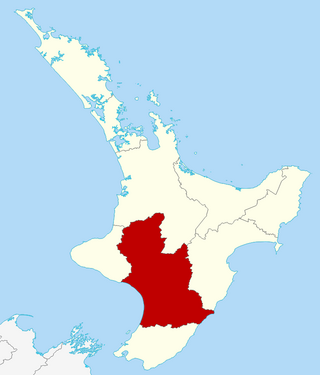
Manawatū-Whanganui is a region in the lower half of the North Island of New Zealand, whose main population centres are the cities of Palmerston North and Whanganui. It is administered by the Manawatū-Whanganui Regional Council, which operates under the name Horizons Regional Council.

<span class="mw-page-title-main">Taumarunui</span> Town in Manawatū-Whanganui Region, New Zealand

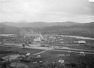
Taumarunui is a small town in the King Country of the central North Island of New Zealand. It is on an alluvial plain set within rugged terrain on the upper reaches of the Whanganui River, 65 km south of Te Kūiti and 55 km west of Tūrangi. It is under the jurisdiction of Ruapehu District and Manawatū-Whanganui region.

<span class="mw-page-title-main">National Park, New Zealand</span> Settlement in Manawatū-Whanganui Region, New Zealand

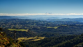
National Park is a small town on the North Island Central Plateau in New Zealand. Also known as National Park Village, it is the highest urban township in New Zealand, at 825 metres. The village has great views of Mount Tongariro, Mount Ngauruhoe, and Mount Ruapehu.

<span class="mw-page-title-main">Raurimu Spiral</span> Section of North Island Main Trunk

The Raurimu Spiral is a single-track railway spiral, starting with a horseshoe curve, overcoming a 139-metre (456 ft) height difference, in the central North Island of New Zealand, on the North Island Main Trunk railway (NIMT) between Wellington and Auckland. It is a notable feat of civil engineering, having been called an "engineering masterpiece." The Institute of Professional Engineers of New Zealand has designated the spiral as a significant engineering heritage site.

<span class="mw-page-title-main">Whanganui River</span> Major river in the North Island of New Zealand

The Whanganui River is a major river in the North Island of New Zealand. It is the country's third-longest river, and has special status owing to its importance to the region's Māori people. In March 2017 it became the world's second natural resource to be given its own legal identity, with the rights, duties and liabilities of a legal person. The Whanganui Treaty settlement brought the longest-running litigation in New Zealand history to an end.

<span class="mw-page-title-main">Kakahi, New Zealand</span>

Kakahi ) is a small King Country settlement about 10 kilometres (6.2 mi) up the Whanganui River from Taumarunui, New Zealand. Founded as a sawmill town, it takes its name from the Māori word for the New Zealand freshwater mussel.

<span class="mw-page-title-main">Ruapehu District</span> Territorial authority district in North Island, New Zealand

Ruapehu District is a territorial authority in the centre of New Zealand's North Island.

<span class="mw-page-title-main">King Country Rugby Football Union</span> Rugby team

The King Country Rugby Football Union is a constituent union in the New Zealand Rugby Union. It is located in the central North Island of New Zealand in an area known as the King Country. It was formed in 1922 when the South Auckland Rugby Union was split into three.

<span class="mw-page-title-main">Manunui</span> Place in Manawatū-Whanganui, New Zealand

Manunui is a small Whanganui River settlement, about 6 kilometres (3.7 mi) east of Taumarunui on State Highway 4, in New Zealand's King Country. It was once known as Waimarino, but John Burnand of the Ellis and Burnand sawmilling firm renamed it Manunui around 1905.

<span class="mw-page-title-main">Ranana</span>

Ranana is a settlement 60 kilometres (37 mi) up the Whanganui River from Whanganui, New Zealand.

<span class="mw-page-title-main">Te Horo railway station</span> Defunct railway station in New Zealand

Te Horo railway station was a flag station at Te Horo, in the Kāpiti Coast District on the North Island Main Trunk in New Zealand.It was served by diesel shuttles between Te Horo and Wellington. Only equipment sheds and a passing loop now remain at the station site.

<span class="mw-page-title-main">Ohakune railway station</span> Railway station in New Zealand

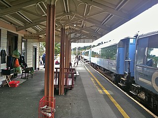
Ohakune railway station is a station on the North Island Main Trunk (NIMT), which serves the town of Ohakune in the Manawatū-Whanganui region of New Zealand. It is served by KiwiRail's Northern Explorer long distance train between Wellington and Auckland. It was called Ohakune Junction from 10 August 1926 until Raetihi Branch closed in 1968, to avoid confusion with Ohakune Town station on that branch. It was the second highest operating railway station in New Zealand, after National Park.

<span class="mw-page-title-main">Makatote Viaduct</span> Viaduct in New Zealand

The Makatote Viaduct takes the North Island Main Trunk railway (NIMT) across the Makatote River in New Zealand. It is 335.7 km (208.6 mi) from Wellington, at the foot of Ruapehu, in northern Manawatū-Whanganui, between Erua and Pokaka.

The Piriaka power station is a hydroelectric power facility in Manawatū-Whanganui in New Zealand which draws water from behind a weir on the Whanganui River near Piriaka and diverts it through a canal and penstock to the Piriaka Power Station, which is located approximately 9 km southeast of the town of Taumarunui, via SH4. The power station discharges back into the Whanganui River.

Tokirima is a valley and rural community, located west of Taumarunui and 19 kilometres (12 mi) south of Ōhura, in the Ruapehu District and Manawatū-Whanganui region of New Zealand's North Island. State Highway 43 and Stratford–Ōkahukura railway line pass through the valley, and Ōhura River passes nearby.

Kaitieke or Kaitīeke is a rural community, located south of Taumarunui and 13 kilometres (8.1 mi) west of Raurimu, in the Ruapehu District and Manawatū-Whanganui region of New Zealand's North Island.

<span class="mw-page-title-main">Kakahi railway station</span> Railway station in New Zealand

Kakahi was a station on the North Island Main Trunk line, in the Ruapehu District of New Zealand, serving Kakahi. It formally opened on 9 November 1908. The rails were laid south of Piriaka by May 1904 and a daily ballast train was running by October, which also carried passengers. Kakahi Bridge has five spans of 44 ft (13 m) and one of 23 ft (7.0 m) supplied by G. Fraser & Sons of Auckland, which delayed construction to the south. It crosses the Kakahi Stream, which was sometimes called the Waitea River.

<span class="mw-page-title-main">Erua railway station</span> Railway station in New Zealand

Erua was a station on the North Island Main Trunk line, in the Ruapehu District of New Zealand. It served the small village of Erua. For a month in 1908 it was the terminus of the line from Auckland. Makatote Viaduct and tramway are about 3 mi (4.8 km) south of Erua.

<span class="mw-page-title-main">Rangiwahia</span> Settlement in New Zealand

Rangiwahia is a small, elevated, farming settlement in the North Island, New Zealand, 26 km (16 mi) northeast of Kimbolton in the Manawatū-Whanganui region. It is in the Kiwitea valley, near the Whanahuia Range of the Ruahines. Due to its height and the nearby ranges, Rangiwahia has a mean annual rainfall of 1267mm; 309mm more than Feilding's.

<span class="mw-page-title-main">Whakahoro</span> Place in New Zealand

Whakahoro is a small settlement located south of Taumarunui on the junction of the Retaruke and Whanganui Rivers, about 104 mi (167 km) upstream from Whanganui. By gravel roads it is 41 km (25 mi) west of Raurimu and 44 km (27 mi) south west of Ōwhango.

References

  1. "Retaruke River, Manawatu-Wanganui". NZ Topo Map. Retrieved 27 June 2021.
  2. Jerome A. Lecointre, Vincent E. Neall & Alan S. Palmer (1998). "Quaternary lahar stratigraphy of the western Ruapehu ring plain". doi: 10.1080/00288306.1998.9514807 .{{cite journal}}: Cite journal requires |journal= (help)
  3. "AtoJs Online — Appendix to the Journals of the House of Representatives — 1910 Session I — C-09 NEW ZEALAND GEOLOGICAL SURVEY (FOURTH ANNUAL REPORT (NEW SERIES) OF THE)". atojs.natlib.govt.nz. 1910. Retrieved 27 June 2021.
  4. Hay, R. F. (1965). "Coal measures in the upper Retaruke Valley". doi: 10.1080/00288306.1965.10428167 .{{cite journal}}: Cite journal requires |journal= (help)
  5. "1:63360 map Sheet: N111 Waimarino". www.mapspast.org.nz. 1977. Retrieved 27 June 2021.
  6. Steve Edbrooke (1998). "Mineral Commodity Report 18" (PDF). Institute of Geological and Nuclear Sciences.
  7. "Kaitieke County Act 1910 (1 GEO V 1910 No 33)" . Retrieved 11 February 2013.
  8. "KAITIEKE. AUCKLAND STAR". paperspast.natlib.govt.nz. 7 May 1913. Retrieved 15 August 2020.
  9. "Manunui Town Board/Town Council | Archives Central". archivescentral.org.nz. Retrieved 15 August 2020.
  10. "Taumarunui County Council". archivescentral.org.nz. Retrieved 15 August 2020.
  11. "New Zealand Gazette" (PDF). 22 May 1913.
  12. "New Zealand Gazette" (PDF). 25 October 1979.
  13. "Bibliography of plant checklists for areas in Whanganui Conservancy" (PDF). March 2010.
  14. "Newsletter" (PDF). New Zealand Botanical Society. June 2001.
  15. "CliFlo – National Climate Database : Lower Retaruke Cws". NIWA. Retrieved 20 May 2024.