Related Research Articles

A borough is an administrative division in various English-speaking countries. In principle, the term borough designates a self-governing walled town, although in practice, official use of the term varies widely.
A riding is an administrative jurisdiction or electoral district, particularly in several current or former Commonwealth countries.
Tangiwai is a 2,696 km2 (1,041 sq mi) census area and a small rural community in the Ruapehu District of the Manawatū-Whanganui region of New Zealand's North Island. It is located east of Ohakune and Rangataua and west of Waiouru on State Highway 49. In 2018 37.5% of the area's 1,281 residents worked in agriculture, forestry and fishing and 7.1% in manufacturing.

Taumarunui is a small town in the King Country of the central North Island of New Zealand. It is on an alluvial plain set within rugged terrain on the upper reaches of the Whanganui River, 65 km south of Te Kuiti and 55 km west of Turangi. It is under the jurisdiction of Ruapehu District and Manawatū-Whanganui region.

National Park is a small town on the North Island Central Plateau in New Zealand. Also known as National Park Village, it is the highest urban township in New Zealand, at 825 metres. Its name derives from its location just outside the boundary of Tongariro National Park, New Zealand's first national park, and its only national park from its creation in 1887 until 1900. The village has great views of Mount Tongariro, Mount Ngauruhoe, and Mount Ruapehu.

Ohakune is a small town in the North Island of New Zealand, situated 215 kilometres north of Wellington and 292 kilometres south of Auckland. It is located at the southern end of the Tongariro National Park, close to the southwestern slopes of the active volcano Mount Ruapehu. Located within the Manawatū-Whanganui region, the town is 70 kilometres northeast of Whanganui and 25 kilometres west of Waiouru.
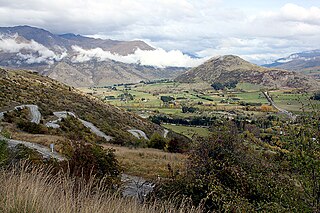
The Crown Range lies to the east of the Wakatipu Basin in Otago, New Zealand. It is noted for two features, the Cardrona Alpine Resort, on the slopes of the 1900 metre Mount Cardrona, and a highway, known as the Crown Range Road, which winds steeply between Arrow Junction, just south of Arrowtown, and Wanaka to the north.

Raetihi is a town in the central North Island of New Zealand. It is located at the junction of State Highways 4 and 49, 11 kilometres west of Ohakune. The 2013 New Zealand census recorded its population as 1,002. This constitutes a decrease of 3.2% or 33 people since the 2006 census. 65.3% of residents identified as Māori, 55% European, 2.7% Pacific and 1.2% Asian. There is evidence of Māori people living here in the fourteenth century. The Ngati Uenuku dwelled at Raetihi and Waimarino. There is little evidence of large permanent settlements but hunting parties were common during warmer months.

Ruapehu District is a territorial authority in the centre of New Zealand's North Island.
The Retaruke River is a river in the North Island of New Zealand. It joins with the Whanganui River just above Wade's Landing and downstream from Taumarunui. The river flows through the farming communities of Upper and then Lower Retaruke Valley. Downstream from this junction is the Mangapurua Landing with its Bridge to Nowhere, servicing the ill-fated Mangapurua Valley farming community.

Nelson Province was constituted in 1853 under the New Zealand Constitution Act 1852, and originally covered the entire upper South Island, including all of present-day Buller, Kaikoura, Marlborough, and Tasman districts, along with Nelson City, Grey District north of the Grey River, and the Hurunui District north of the Hurunui River. It was reduced in size by the creation of Marlborough Province in November 1859, then abolished in 1876, along with all the provinces of New Zealand.
The Raetihi Branch was a branch line railway in the central North Island of New Zealand. It formed part of New Zealand's national rail network and operated from 1917 until 1968.

Michael Moohan was a New Zealand politician of the Labour Party. Seldom known to anyone by anything other than "Mick", he was a major organizational figure in the Labour Party's early history and went on to become a significant politician in his own right as an MP and cabinet minister.
Waimarino was a New Zealand parliamentary electorate that existed from 1911 to 1954, and from 1963 to 1972. It was rural in nature and was represented by four Members of Parliament.
State Highway 49 (SH 49) is a New Zealand state highway, linking SH 4 and SH 1, via the tourist town of Ohakune. It forms the southern part of the ring road surrounding Tongariro National Park and provides access to the southern side of Mount Ruapehu and the Turoa skifield. It roughly follows the North Island Main Trunk railway.
Taumarunui was a parliamentary electorate in the King Country in the Manawatu-Wanganui region of New Zealand from 1908 to 1919. The electorate was represented by two Members of Parliament.
Waimarino is the original name of the town National Park, New Zealand. It was renamed to avoid confusion, as increasingly the wider area was referred to by the same name. The following may refer to Waimarino:
Kaitieke or Kaitīeke is a rural community, located south of Taumarunui and 13 kilometres (8.1 mi) west of Raurimu, in the Ruapehu District and Manawatū-Whanganui region of New Zealand's North Island.
References
- ↑ "Kaitieke County Act 1910 (1 GEO V 1910 No 33)" . Retrieved 11 February 2013.
- ↑ "Waimarino District Council". Archives Central. 23 April 2014. Retrieved 21 July 2019.
| This Manawatū-Whanganui geography article is a stub. You can help Wikipedia by expanding it. |