
The Waipā River is in the Waikato region of the North Island of New Zealand. The headwaters are in the Rangitoto Range east of Te Kūiti. It flows north for 115 kilometres (71 mi), passing through Ōtorohanga and Pirongia, before flowing into the Waikato River at Ngāruawāhia. It is the Waikato's largest tributary. The Waipā's main tributary is the Puniu River.

The Buller River is a river in the South Island of New Zealand. The Buller has the highest flow of any river in the country during floods, though it is only the 13th longest river; it runs for 177 km (110 mi) from Lake Rotoiti through the Buller Gorge and into the Tasman Sea near the town of Westport. A saddle at 710 m (2,330 ft) separates the Buller from the Motupiko River and that is divided from the Wairau River by a 695 m (2,280 ft) saddle, both aligned along the Alpine Fault, as is the top of the Buller valley.
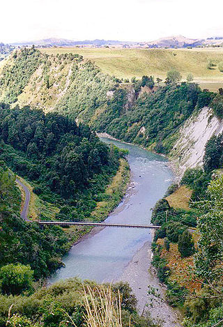
The Rangitīkei River is one of New Zealand's longest rivers, 253 kilometres (157 mi) long.

The Whanganui River is a major river in the North Island of New Zealand. It is the country's third-longest river, and has special status owing to its importance to the region's Māori people. In March 2017 it became the world's second natural resource to be given its own legal identity, with the rights, duties and liabilities of a legal person. The Whanganui Treaty settlement brought the longest-running litigation in New Zealand history to an end.

Stony Batter is a historic defence installation at the north-eastern end of Waiheke Island, Auckland, New Zealand. It is sited within a 50-acre scenic reserve of the same name, owned by the New Zealand Department of Conservation (DOC). The park serves double duty as a historical and nature reserve, containing unusual rock formations, associated with an extinct volcano, three significant bush blocks and three concrete gun emplacements with an extensive tunnel system, reputed to be the largest in New Zealand.

The Whakapapa River in New Zealand forms from streams which trickle off the Whakapapa skifield of Mount Ruapehu and down the western slopes of the mountain. The river passes near Ōwhango, before finally merging with the Whanganui River just east of Kakahi, about 40 km (25 mi) from where it starts, which is in a 100 m (330 ft) deep gorge, at the confluence of the Whakapapaiti and Whakapapanui Streams.
Birchville is a suburb of Upper Hutt, New Zealand in the North Island. Its centre lies at the entrance to the Akatarawa Valley, in the north of the city, near confluence of the Akatarawa River with the Hutt River. It is about a 5 km (10-minute) drive north from the centre of Upper Hutt. The Birchville community is spread out along both banks of the Hutt River in a long fairly narrow valley.

The Whanganui Journey is a river journey along the Whanganui River in the North Island of New Zealand, travelling by canoe or kayak. The route runs from Taumarunui to Pipiriki, is 145 km long and usually takes 5 days to complete. It is managed by New Zealand's Department of Conservation under its Great Walks programme, and much of the route travels through land that is part of the Whanganui National Park.
Mangamahu is a hill-country farming and forestry community in the middle reaches of the Whangaehu River valley, in the Whanganui District and Rangitikei District of Manawatū-Whanganui, New Zealand. It is centred on the village of Mangamahu, which is situated on river flats where the Mangamahu stream flows into the Whangaehu river. Mangamahu has a primary school which has been open since 1894 and a War Memorial hall built in 1952.
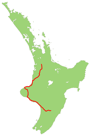
State Highway 3 (SH 3) is one of New Zealand's eight national state highways. It serves the west coast of the country's North Island and forms a link between State Highway 1 and State Highway 2. Distances are measured from north to south.

Craigieburn Forest Park is a protected area in the South Island of New Zealand, adjacent to Arthur's Pass National Park to the north.

The bridges in New Zealand are many and varied but only date back to the beginning of European settlement in the mid 19th century.

The Tongariro Power Scheme is a 360 MW hydroelectricity scheme in the central North Island of New Zealand. The scheme diverts water from tributaries of the Rangitikei, Whangaehu, Whanganui, and Tongariro rivers. These rivers drain a 2,600-square-kilometre (1,000 sq mi) area including Ruapehu, Ngauruhoe, Tongariro and the western Kaimanawa Ranges. The water diverted from these rivers is sent through canals and tunnels to generate electricity at three hydro power stations, Rangipo (120 MW), Tokaanu (240 MW) and Mangaio (2 MW). The water is then discharged into Lake Taupō where it adds to the water storage in the lake and enables additional electricity generation in the succession of power stations down the Waikato River.

The Ngākawau River is a river of the West Coast Region of New Zealand's South Island. It flows generally northwest, reaching the Tasman Sea at Hector.

The Tangahoe River is a river of the Taranaki Region of New Zealand's North Island. It flows generally southwest from its origins in hill country to the east of Lake Rotorangi, reaching the Tasman Sea in the South Taranaki Bight 5 km (3.1 mi) southeast of Hawera.
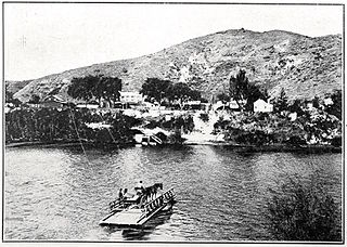
Upokongaro or Ūpokongaro is a settlement 12 kilometres (7.5 mi) upriver from Whanganui, New Zealand, in the Makirikiri Valley. Settled by Europeans in the 1860s, it was an important ferry crossing and riverboat stop. A spectacular discovery of moa bones was made in the area in the 1930s.

The Makatote Viaduct takes the North Island Main Trunk railway (NIMT) across the Makatote River in New Zealand. It is 335.7 km (208.6 mi) from Wellington, at the foot of Ruapehu, in northern Manawatū-Whanganui, between Erua and Pokaka.
Ballance is a farming community in Tararua District and Manawatū-Whanganui region of New Zealand's North Island. The main settlement is located on the west back of the Mangahao River, south and west of Woodville and 11 km north-west of Pahiatua.

Matapuna had several sidings on the North Island Main Trunk line, in the Ruapehu District of New Zealand, serving the east Taumarunui suburb on the north bank of the Whanganui River. It was 2.9 km (1.8 mi) north west of Manunui and 2.95 km (1.83 mi) east of Taumarunui. Work was largely complete by May 1903, and freight was handled from 22 June 1903. A fixed signal was placed at the station and a distant at the bridge in 1917 and the ballast pit siding was interlocked by tablet in 1918. A racecourse opened to the south of the bridge in 1916 and some trains served the course on race days, though no platform appears on aerial photos and only the ballast pit was mapped.

Rangiwahia is a small, elevated, farming settlement in the North Island, New Zealand, 26 km (16 mi) northeast of Kimbolton in the Manawatū-Whanganui region. It is in the Kiwitea valley, near the Whanahuia Range of the Ruahines. Due to its height and the nearby ranges, Rangiwahia has a mean annual rainfall of 1267mm; 309mm more than Feilding's.

