Tongariro Alpine Crossing

Last updated

Tongariro Alpine Crossing
Tongariro Crossing Emerald Lakes Blue Lake.jpg
View from the summit over the Emerald Lakes, across the Central Crater, to Blue Lake. Autumn 2004.
Length19.4 km (12.1 mi)
Location
Trailheads Mangatepopo Carpark
Ketetahi Carpark
UseHiking
Highest pointRed Crater, 1,886 m (6,188 ft)
Lowest pointKetetahi Carpark, 760 m (2,490 ft)
DifficultyModerate
Website www.doc.govt.nz/parks-and-recreation/tracks-and-walks/central-north-island/ruapehu/tongariro-alpine-crossing/

The Tongariro Alpine Crossing in Tongariro National Park is a tramping track in New Zealand, and is among the most popular day hikes in the country. [1] The Tongariro National Park is a World Heritage site which has the distinction of dual status, as it has been acknowledged for both its natural and cultural significance. [2]

Contents

The crossing passes over the volcanic terrain of the multi-cratered active volcano Mount Tongariro, passing the eastern base of Mount Ngauruhoe.

The full distance of the track is usually 19.4-kilometre (12.1 mi). [3] [4]

Walk details

The Tongariro Alpine Crossing is usually walked from Mangatepopo in the Ruapehu region to Ketetahi Hot Springs, due to the Mangatepopo end being higher in altitude (1,120 m or 3,670 ft) than the Ketetahi Hot Springs end (760 m or 2,490 ft), therefore requiring less climbing. [5] The crossing takes about seven hours of steady walking to complete in good weather, taking longer in winter or if walked from the Ketetahi end. [5]

The steaming moonscape of South Crater on the Tongariro Alpine Crossing South Crater - Mt Tongariro.JPG
The steaming moonscape of South Crater on the Tongariro Alpine Crossing

As off October 2023, the Department of Conservation instituted a booking system for the hike in order to gather better information about its usage. [6]

The crossing is a linear journey, starting on the west side of Mount Tongariro and finishing on the north side. Originally, this meant that returning to the western end required, retracing the 19.4 km crossing, walking 26 km via State Highways 46 and 47 back to the other trailhead, or completing the Tongariro Northern Circuit. Nowadays there are many local companies that offer shuttle services between the track end points

The track begins at the western end near the Mangatepopo Hut with a low gradient until the foot of the steep Tongariro saddle. After the climb to the saddle, the path takes descents and ascents into and back out of two different craters, passing the Emerald Lakes and along the edge of the Blue Lake. The last two hours of the walk involve a long descent down the northern flank of the volcano, passing the Ketetahi Hot Springs. New Zealand Mountain Safety Council's video on the Tongariro Alpine Crossing

Climbing of Mount Ngauruhoe as a side trip from the main crossing is not allowed anymore (as requested by the local iwi ) and track markings were removed. [7]

Mt Ruapehu peeking above the rolling tussock mounds at the start of the Tongariro Alpine Crossing Mt Ruapehu.JPG
Mt Ruapehu peeking above the rolling tussock mounds at the start of the Tongariro Alpine Crossing

There are no guaranteed fresh water supplies on the walk. Springs in the area are often scalding hot and tainted with minerals and dissolved metals from the volcanic activity. Most natural water in the area is not drinkable. The Ketetahi Hot Springs, about 10 minutes from the Ketetahi hut, is privately owned by the local iwi Tuwharetoa and has been placed out of bounds since the 1990s when a tourist was scalded to death.[ citation needed ]

PointDistanceTimeAltitudeCoordinates
Mangatepopo Carpark0.0 km (0.0 mi)0h 00m1,120 m (3,670 ft) 39°08′40″S175°34′52″E / 39.144486°S 175.58106°E / -39.144486; 175.58106 (Mangatepopo Carpark)
Mangatepopo Hut1.5 km (0.9 mi)0hr 25m1,190 m (3,900 ft) 39°08′41″S175°35′48″E / 39.144673°S 175.596638°E / -39.144673; 175.596638 (Mangatepopo Hut)
Soda Springs turn-off1h 30m1,350 m (4,430 ft) 39°08′24″S175°37′29″E / 39.140051°S 175.624619°E / -39.140051; 175.624619 (Soda Springs turn-off)
South Crater6.4 km (4.0 mi)2h 30m1,650 m (5,410 ft) 39°08′35″S175°38′04″E / 39.14309°S 175.63450°E / -39.14309; 175.63450 (South Crater)
Red Crater summit3h 30m1,886 m (6,188 ft) 39°08′08″S175°39′01″E / 39.13563°S 175.65034°E / -39.13563; 175.65034 (Red Crater summit)
Emerald Lakes (Oturere Hut turn-off)9.0 km (5.6 mi)3h 50m1,695 m (5,561 ft) 39°07′58″S175°39′23″E / 39.132657°S 175.656277°E / -39.132657; 175.656277 (Emerald Lakes turn-off)
Ketetahi Hut5h 15m1,450 m (4,760 ft) 39°06′29″S175°39′11″E / 39.107921°S 175.652976°E / -39.107921; 175.652976 (Ketetahi Hut)
Ketetahi Carpark19.4 km (12.1 mi)7h 00m760 m (2,490 ft) 39°04′25″S175°39′50″E / 39.073669°S 175.6638°E / -39.073669; 175.6638 (Ketetahi carpark)
PanoramaFromMtNgauruhoe.jpg
Panorama view from Mt Ngauruhoe in Tongariro National Park

Alpine exposure and 2007 name change

Until 2007 the crossing was called the "Tongariro Crossing", but this was changed to the "Tongariro Alpine Crossing" to emphasize the extreme weather on the exposed terrain. Almost the entire length of the crossing is in volcanic terrain with no vegetation and fully exposed to weather – at moderate altitude. As the crossing is easily accessible, it is walked by large numbers of tourists and casual walkers each year. The Department of Conservation is concerned about trampers being unprepared for the conditions they may encounter and introduced the name change to warn the many poorly equipped visitors of potential hazards. Key hazards are the high wind chill factor, the rapid change in weather and very poor visibility in the sudden storms with blinding snow and cloud. In 2006, two people of an estimated 65,000 walkers died on the track. Although the route is marked with poles, it is quite common in poor weather for visibility to be severely reduced. Poles may be snow covered or destroyed by wind gusts in winter. [3]

Volcanic features

A view of harsh volcanic landscape on the Tongariro Alpine Crossing Volcanic features in Tongariro Alpine Crossing.jpg
A view of harsh volcanic landscape on the Tongariro Alpine Crossing

Most of the walk is through raw volcanic terrain. The three volcanoes in the area are all highly active and the terrain reflects this. Solidified lava flows, loose tephra, and solidified volcanic lava bombs abound. Large amounts of minerals are brought to the surface and are highly visible in the colours of rocks and ridges. Active fumaroles abound on several sections of the walk, constantly emitting steam and sulphur dioxide gas into the air and depositing yellow sulphur specks around their edges. The lakes and pools on the walk are deeply coloured by the volcanic minerals dissolved in them. Some areas feature large springs emitting near-boiling water and torrents of steam. The terrain underfoot for most of the walk is either sharp edged new volcanic rock or loose and shifting tephra, mainly ash and lapilli. In some crater areas it is finer ash that has become moist and compacted.

Tongariro Alpine Crossing from Central Crater in summer Tongariro Alpine Crossing from Central Crater in Summer.JPG
Tongariro Alpine Crossing from Central Crater in summer

In August 2012 a small eruption of 10,000 cubic metres of ash from the Te Maari (sometimes spelled Te Māri or Te Mari) craters on Mt Tongariro sent a shower of ash and blocks up to 1m in diameter over the track. The blocks damaged the roof of the Ketetahi hut which is 1.5 km west of the explosive craters. No one was hurt. The alpine crossing was temporarily closed as about 75% of the track is within 3 km of Te Maari. The track is usually to windward of Te Maari as the prevailing wind is west to south west in this region. When mixed with rain the ash forms a gritty mud. In late November 2012 Te Maari crater again erupted an ash cloud 4,000m high over a 5-minute period. About 100 people were in the vicinity including a group of 20 13-year-old students from Gulf Harbour school but no one was injured. The crater is visible from the Ketetahi area. There are no tracks to Te Maari as it is an unstable, volcanically active zone. The Tongariro Alpine track was closed for 4 days but the other 12 tracks on the mountains were left open. Fumaroles remain active around the active rim of Te Maari crater and there is a strong smell of sulphur gas close to the rim. [8]

See also

View of Mount Ngauruhoe from Red Crater on Mt Tongariro Mt Ngauruhoe.JPG
View of Mount Ngauruhoe from Red Crater on Mt Tongariro

Related Research Articles

<span class="mw-page-title-main">Mount Ruapehu</span> Volcano in New Zealand

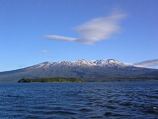
Mount Ruapehu is an active stratovolcano at the southern end of the Taupō Volcanic Zone and North Island volcanic plateau in New Zealand. It is 23 km (14 mi) northeast of Ohakune and 23 km (14 mi) southwest of the southern shore of Lake Taupō, within the Tongariro National Park. The North Island's major ski resorts and only glaciers are on its slopes.

<span class="mw-page-title-main">Taupō Volcanic Zone</span> Active volcanic zone in New Zealand

The Taupō Volcanic Zone (TVZ) is a volcanic area in the North Island of New Zealand that has been active for at least the past two million years and is still highly active. Mount Ruapehu marks its south-western end and the zone runs north-eastward through the Taupō and Rotorua areas and offshore into the Bay of Plenty. It is part of a larger Central Volcanic Region that extends to the Coromandel Peninsula and has been active for four million years. The zone is contained within the tectonic intra-arc continental Taupō Rift and this rift volcanic zone is widening unevenly east–west with the greatest rate of widening at the Bay of Plenty coast, the least at Mount Ruapehu and a rate of about 8 mm (0.31 in) per year at Taupō. The zone is named after Lake Taupō, the flooded caldera of the largest volcano in the zone, the Taupō Volcano and contains a large central volcanic plateau as well as other landforms.

<span class="mw-page-title-main">New Zealand tramping tracks</span>

In New Zealand, long distance walking or hiking for at least one overnight stay is known as tramping. There are a number of walkways in New Zealand, however most of these are relatively short and can be walked in a day or less. Many are also an easy walk, with well formed footpaths. However, some tracks require an overnight stay either because of the rugged country or the length of the track.

<span class="mw-page-title-main">Mount Taranaki</span> Volcano in North Island of New Zealand

Mount Taranaki is a dormant stratovolcano in the Taranaki region on the west coast of New Zealand's North Island. At 2,518 metres (8,261 ft), it is the second highest mountain in the North Island, after Mount Ruapehu. It has a secondary cone, Fanthams Peak, 1,966 metres (6,450 ft), on its south side.

<span class="mw-page-title-main">Mount Ngauruhoe</span> Active volcano in New Zealand

Mount Ngauruhoe is a volcanic cone in New Zealand. It is the youngest vent in the Tongariro stratovolcano complex on the Central Plateau of the North Island and first erupted about 2,500 years ago. Although often regarded as a separate mountain, geologically, it is a secondary cone of Mount Tongariro.

<span class="mw-page-title-main">Arthur's Pass National Park</span> National park in New Zealand

Arthur's Pass National Park is located in the South Island of New Zealand and covers 1,185 km2 of mostly mountainous terrain. Adjacent to it lies Craigieburn Forest Park. The park is administered by the Department of Conservation.

<span class="mw-page-title-main">Tongariro National Park</span> National park in New Zealand

Tongariro National Park is the oldest national park in New Zealand, located in the central North Island. It has been acknowledged by UNESCO as a World Heritage Site of mixed cultural and natural values.

<span class="mw-page-title-main">Mount Tongariro</span> Compound volcano in New Zealand

Mount Tongariro is a compound volcano in the Taupō Volcanic Zone of the North Island of New Zealand. It is located 20 km (12 mi) to the southwest of Lake Taupō, and is the northernmost of the three active volcanoes that dominate the landscape of the central North Island.

<span class="mw-page-title-main">North Island Volcanic Plateau</span> A pyroclastic volcanic plateau on the North Island of New Zealand

The North Island Volcanic Plateau is a volcanic plateau covering much of central North Island of New Zealand with volcanoes, lava plateaus, and crater lakes. It contains the Taupō caldera complex, Ōkataina caldera complex and Tongariro Volcanic Centre resulting in it being currently the most frequently active and productive area of silicic volcanism on Earth. New Zealand is part of the Pacific Ring of Fire.

<span class="mw-page-title-main">Rangipo Desert</span> Geographic feature in New Zealand

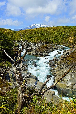
Te Onetapu, commonly known as the Rangipo Desert, is a barren desert-like environment located in New Zealand, located in the Ruapehu District on the North Island Volcanic Plateau; to the east of the three active peaks of Mount Tongariro, Mount Ngauruhoe, and Mount Ruapehu, and to the west of the Kaimanawa Range.

<span class="mw-page-title-main">New Zealand Great Walks</span> Set of tramping tracks

The New Zealand Great Walks are a set of popular tramping tracks developed and maintained by the Department of Conservation. They are New Zealand's premier tracks, through areas of some of the best scenery in the country, ranging from coastlines with beaches to dense rain forests and alpine terrain. The tracks are maintained to a high standard, making it easier for visitors to explore some of the most scenic parts of New Zealand's backcountry.

<span class="mw-page-title-main">Mount Tauhara</span> Lava dome volcano on North Island, New Zealand

Mount Tauhara is a dormant lava dome volcano in New Zealand's North Island, reaching 1,088 metres (3,570 ft) above sea level. It is situated in the area of caldera rim overlap of the Whakamaru Caldera and Taupō Volcano towards the centre of the Taupō Volcanic Zone, which stretches from Whakaari / White Island in the north to Mount Ruapehu in the south. It is 6 kilometres (4 mi) east of the town of Taupō, next to the northeastern shore of Lake Taupō.

<span class="mw-page-title-main">Ngātoro-i-rangi</span>

In Māori tradition, Ngātoro-i-rangi (Ngātoro) is the name of a tohunga (priest) prominent during the settling of New Zealand (Aotearoa) by the Māori people, who came from the traditional homeland Hawaiki on the Arawa canoe. He is the ancestor of Ngāti Tūwharetoa and his travels around Lake Taupō and up onto the Volcanic Plateau are the basis of Ngāti Tūwharetoa's claim to those regions.

<span class="mw-page-title-main">Tongariro Northern Circuit</span> Hiking trail in Tongariro National Park, New Zealand

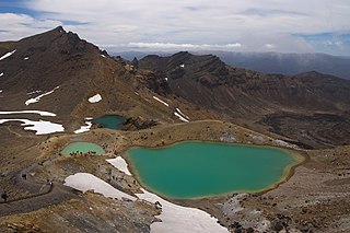
The Tongariro Northern Circuit, one of the New Zealand Great Walks, offers a three- to four-day tramp through Tongariro National Park New Zealand. Highlighted by the Tongariro Alpine Crossing, a full day of awe-inspiring landscapes, The entire trail spans a 50-kilometre (31 mi) around Mount Ngauruhoe. Approximately 2,500 hikers completed the walk in the 2021/22 season. This contrasts with the roughly 25,000 who solely walk the Tongariro Crossing segment.

<span class="mw-page-title-main">Volcanism of New Zealand</span> Volcanic activity of New Zealand

The volcanism of New Zealand has been responsible for many of the country's geographical features, especially in the North Island and the country's outlying islands.

<span class="mw-page-title-main">Geology of New Zealand</span> Overview of the geology of New Zealand

The geology of New Zealand is noted for its volcanic activity, earthquakes and geothermal areas because of its position on the boundary of the Australian Plate and Pacific Plates. New Zealand is part of Zealandia, a microcontinent nearly half the size of Australia that broke away from the Gondwanan supercontinent about 83 million years ago. New Zealand's early separation from other landmasses and subsequent evolution have created a unique fossil record and modern ecology.

<span class="mw-page-title-main">Hauhungatahi</span>

Hauhungatahi is an eroded andesitic volcano at the southern end of the Taupo Volcanic Zone in New Zealand, located about 12 kilometres (7 mi) north–west of Mount Ruapehu. Although relatively little-known, at 1,521 metres (4,990 ft) Hauhungatahi is one of the highest volcanoes in New Zealand, exceeded in elevation by only Ruapehu, Taranaki/Egmont, and the Tongariro massif.

<span class="mw-page-title-main">Whangaehu</span>

Whangaehu is a settlement in the Rangitikei District and Manawatū-Whanganui region of New Zealand's North Island.

<span class="mw-page-title-main">Horace Holl</span> New Zealand mountaineer and rock climber

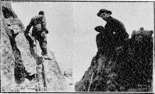
Horace Arthur Holl was a New Zealand mathematician, mountaineer and rock climber. He climbed extensively in the Southern Alps, including two summits of Mount Cook within a fortnight, first via the Linda Glacier and then via Earl's Route. In the final decade of his life, he made frequent visits to Tongariro National Park and it is estimated that he ascended Mount Ruapehu about 50 times.

<span class="mw-page-title-main">Copland Track</span> New Zealand tramping track

The Copland Track is a tramping track in the south Westland area of New Zealand's South Island, well known for the naturally-occurring hot springs at Welcome Flat along its route. The main track is approximately 25 kilometres (16 mi) long one-way from the trailhead at State Highway 6 to the track's inland end at the Douglas Rock Hut, and is usually completed in 2 to 4 days depending on whether the full distance is walked, with many opting to walk only as far as Welcome Flat. The track is the western portion of a longer path which historically connected the West Coast to Mount Cook Village via Copland Pass, however erosion and the retreat of the Hooker Glacier has led to the eastern side of this route becoming increasingly dangerous to traverse.

References

  1. DuFresne, J. (2006). Tramping in New Zealand. page 84. Lonely Planet Publications Pty Ltd.
  2. Department of Conservation (2008). Tongariro Alpine Crossing Fact Sheet [brochure]. Department of Conservation, Ruapehu Area Office.
  3. 1 2 "Crossing's new name will give trampers more clues about terrain". New Zealand Herald . 29 October 2007. Retrieved 29 October 2007.
  4. tvnz.co.nz: Tongariro ready to be crossed again
  5. 1 2 "Track description -- Tongariro Alpine Crossing". Department of Conservation. Retrieved 22 November 2012.
  6. "Book in to protect the Tongariro Alpine Crossing". www.doc.govt.nz. Retrieved 19 May 2024.
  7. "Trampers told not to climb Tongariro Crossing's Mount Doom". stuff.co.nz . 16 October 2017. Retrieved 30 January 2018.
  8. TV1 news.Nov 27 2012.