
The North Island, also officially named Te Ika-a-Māui, is one of the two main islands of New Zealand, separated from the larger but much less populous South Island by the Cook Strait. The island's area is 113,729 square kilometres (43,911 sq mi), making it the world's 14th-largest island. It has a population of 3,925,800, accounting for approximately 77% of the total residents of New Zealand.
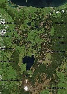
The Taupō Volcanic Zone (TVZ) is a volcanic area in the North Island of New Zealand that has been active for the past two million years and is still highly active. Mount Ruapehu marks its south-western end and the zone runs north-eastward through the Taupō and Rotorua areas and offshore into the Bay of Plenty. It is part of the larger Central Volcanic Region that extends further westward through the western Bay of Plenty to the eastern side of the Coromandel Peninsula and has been active for four million years. At Taupō the volcanic zone is widening east–west at the rate of about 8 mm per year while at Mount Ruapehu it is only 2–4 mm per year but this has increases at the north eastern end at the Bay of Plenty coast to 10–15 mm per year. It is named after Lake Taupō, the flooded caldera of the largest volcano in the zone, the Taupō Volcano.

Te Onetapu, commonly known as the Rangipo Desert, is a barren desert-like environment in New Zealand, located in the Ruapehu District on the North Island Volcanic Plateau; to the east of the three active peaks of Mount Tongariro, Mount Ngauruhoe, and Mount Ruapehu, and to the west of the Kaimanawa Range.
Hunterville is a small community on State Highway 1, in the Rangitikei district of the North Island of New Zealand. It is located halfway between Taupo and Wellington and has a population of 411, a decrease of 18 people from 2013.

The Rangitikei District is a territorial authority located primarily in the Manawatū-Whanganui region in the North Island of New Zealand, although a small part, the town of Ngamatea, lies in the Hawke's Bay Region. It is located in the southwest of the island, and follows the catchment area of the Rangitīkei River.
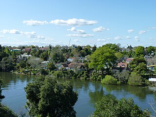
Claudelands is a suburb directly to the east of central Hamilton, New Zealand, across the Waikato River. It is linked to the central city by the Claudelands road bridge and the East Coast Main Trunk Railway bridge.

The Melbourne Rectangular Stadium, known as AAMI Park for sponsorship reasons, is an outdoor sports stadium on the site of Edwin Flack Field in the Sports and Entertainment Precinct in the Melbourne City Centre.
Rangitikei is an area in New Zealand that follows the course of State Highway 1, from just south of Waiouru with the QEII Army Memorial Museum, through Taihape, Mangaweka, Hunterville, Marton and Bulls, and then winds down a minor road to the coast at Turakina & Scott's Ferry.
The Rangitikei District Council is the local government authority for Rangitikei District in New Zealand. It is a territorial authority elected to represent the 16,050 people of Rangitikei. Since October 2013, the Mayor of Rangitikei is Andy Watson, who succeeded Robert "Chalky" Leary. The council consists of a mayor who is elected at large, and 11 councillors elected across three wards, one of whom gets chosen as deputy mayor. There are also two community boards – for Rātana and Taihape. The councillors are elected under the first-past-the-post (FPTP) system in triennial elections.
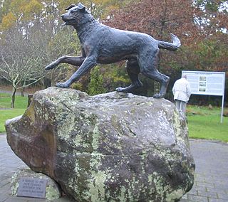
The Great Northern Steeplechase is New Zealand's richest steeplechase. It is run over 6,400 metres (21,000 ft) at Ellerslie Racecourse in Auckland, making it Australasia's longest horse race, and usually takes between eight and eight and a half minutes to complete. The race has been run in early September since 2005, after previously being held in early June.

Long Bay is one of the northernmost suburbs of the North Shore, part of the contiguous Auckland metropolitan area located in New Zealand.
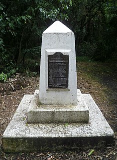
Robert Cunningham Bruce was a Scottish-born sailor, New Zealand politician and conservationist.

Whanganui District is one of the districts of New Zealand. It includes the city of Whanganui and surrounding areas.

Crawshaw is a compact suburb, close to Te Rapa railway depot, in western Hamilton in New Zealand, and extended in the 2018 census to cover 0.86 km2. Although sometimes referred to as a suburb in its own right, it is often described as being part of Nawton.

State Highway 48 (SH 48), also known as Bruce Road, is one of New Zealand's shortest state highways. It provides access to Whakapapa Skifield on the slopes of Mount Ruapehu. It is roughly 7 kilometres (4.3 mi) long and, with the exception of the junction with SH 47, it lies entirely within Tongariro National Park. SH 48 includes the highest point of the state highway network, 1,153 metres (3,783 ft) above sea level.

Hunterville railway station was a station on the North Island Main Trunk in New Zealand, serving the township of Hunterville.

Silverhope railway station was a station on the North Island Main Trunk in New Zealand, 12 mi 9 ch (19.5 km) from Marton. Goods were first carried to the station on 19 October 1887, though the official opening of the 15 mi 57 ch (25.3 km) Marton to Hunterville section wasn't until Saturday 2 June 1888, when the station was served by two trains a week, reported as losing £15 a week. A Certificate of Inspection for the line was issued on Wednesday, 6 June 1888.

The Whanganui District Health Board is a district health board with the focus on providing healthcare to the Wanganui, Rangitikei, and parts of the Ruapehu districts of New Zealand.

Porewa is a rural community, in the Rangitikei District of the Manawatū-Whanganui region of New Zealand's North Island.
The Mayor of Rangitikei is the head of the Rangitikei District Council in New Zealand. The role was created in 1989 with the formation of the Rangitikei District as part of the 1989 local government reforms. The current mayor since 2013 is Andy Watson from Marton.
