Whitireia Park

Last updated

Whitireia Park
Titahi Bay from Whitirea Park - panoramio.jpg
Whitirea Park, with Titahi Bay in the background
TypeRegional park
Location Lower Hutt, Wellington Region, New Zealand
Coordinates 41°06′23″S174°50′29″E / 41.1063681°S 174.8413128°E / -41.1063681; 174.8413128
Area180 hectares (440 acres)
Operated by Wellington Regional Council
Open6am-6pm (May-August)
6am-7pm (September)
6am-8pm (October)
6am-9pm (November-February)
6am-8pm (March)
6am-7pm (April)

Whitireia Park is a headland north of Titahi Bay and Te Awarua-o-Porirua Harbour in Porirua, in the Wellington Region at the southern end of New Zealand's North Island. It is a regional park administered by Wellington Regional Council. [1]

Contents

The park includes Onehunga Bay, Kaitawa Point and part of Rocky Bay. [1]

Geography

The park covers 180 hectares (440 acres) of hilly headland, consisting mostly of open grasslands with some native bush. [1]

The headland has uplifted from the harbour during a series of earthquakes over the past one or two million years. The most recent earthquake in January 1855 created the marshland at Te Onepoto Bay and the western coastline beaches, and made Porirua Harbour too shallow for large sailing ships. [2]

Te Onepoto Bay now provides a habitat for water birds, including kingfishers and white-faced herons. There are also some little shags, black shags, royal spoonbills, black backed gulls and shore plover. [2]

There is 2 hectares (4.9 acres) of remnant coastal kohekohe forest, with two rare streblus banksii trees and doodia australis fern. [2]

The wetland behind the Onehunga Bay carpark is dominated by toetoe and flax, where pūkeko, paradise ducks and other wetland birds live. The dunes at the bay are also being planted with spinifex, pingao, shore spurge, sand tussock, sand daphne and native iris, where native insects and lizards live. [2]

History

Pre-European history

Polynesian explorer Kupe is believed to have landed just south of Titahi Bay at Komangarautawhiri. According to oral history, his canoe floated away on the outgoing tide and then returned to shore on an incoming tide. [3]

The anchor stone of Kupe's canoe is believed to have remained in Onehunga Bay for centuries and was respected by Māori tribes. During the 1840s, British troops drowned after breaking chips off the stone, and some Māori believed it was punishment for sacrilege. The stone is now stored at Museum of New Zealand Te Papa Tongarewa, but there is a monument at the Onehunga Bay carpark. [1]

Before European settlement, Māori fished the waters for kina, pāua and kuku. [3]

Ngāti Toa conquered the area in the mid-1820s under the leadership of Te Rauparaha, partly due to its strategic position near early European trading ports. The headland had sparse vegetation, and the population lived on a diet of seafood, bracken ferns and kumara, and their kumara-growing terraces are still visible above the headland cliffs. [3]

An archaeological survey by the Department of Conservation suggests Māori occupation continued until 1840s. [4]

Trust reserve

Fire in Whitireia Park in 2010 Titahi Bay Scrub Fire.jpg
Fire in Whitireia Park in 2010
Helicopters fighting fire in Whitireia Park in 2010 FIRE! Helicopter water bombers called in to dowse flames of a major bushfire in Titahi Bay, New Zealand -b.jpg
Helicopters fighting fire in Whitireia Park in 2010

The park was established by a local trust board and the Broadcasting Corporation of New Zealand in 1976, with support from Ngāti Toa and local businesses. [3] Under a management plan finalised in 1978, the Department of Conservation was also involved in managing the park. [5]

In the decades since, a track has been built around the park, and the New Zealand Defence Force has removed abandoned motor vehicle bodies from around the headland. Radio New Zealand has maintained control of 53 hectares (130 acres) of the park as a base for a radio transmitter, but most of its land is leased for grazing to reduce fire risk. [3]

In 2006, work began on replanting the wetland behind the Onehunga Bay carpark. [2]

Much of the vegetation on the headland was destroyed in a fire in February 2010. [6] Working bees have been organised to replant the park. [7]

Regional park

Wellington Regional Council took control of the park in March 2011, with Ngāti Toa continuing to be involved in its management. [3] [5]

Dog leashes became mandatory at Onehunga Bay in February 2017. [8]

In 2018, Radio New Zealand proposed having some of its greenfield land rezoned for residential development. [9]

Part of the park walking track was closed in July 2021 due to a sewage leak. [10]

Recreation

The park has views over Mana Island and the South Island to the west, Te Awarua-o-Porirua Harbour to the east and south. [1]

The Onepoto loop track runs up the hill from Onehunga Bay, down through the inland valley and back through to the bay. It takes almost two hours to complete, and requires moderate fitness and decent footwear. [7] [11] Parts of the track are exposed to sea winds. [12]

The park is also used for fishing, mountain biking, horse riding, rock climbing, bird spotting, orienteering, model plane flying, canoeing, kitesurfing, diving, picnicking and swimming. [1] [7] [5]

The park is open 6am-6pm from May to August, 6am-7pm during September, 6am-8pm during October, 6am-9pm from November to February, 6am-8pm during March, and 6am-7pm during April. The park may be closed at any time due to weather conditions. [1]

Dogs are permitted but must be kept under control, and must be kept on a leash at Onehunga Bay. Fire and fireworks are banned at all times. [1]

Related Research Articles

<span class="mw-page-title-main">Wellington</span> Capital city of New Zealand

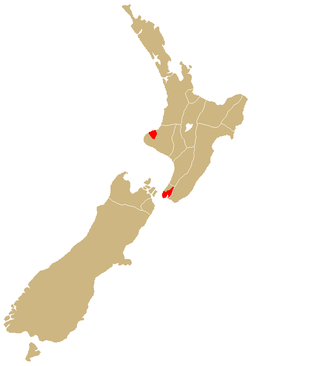
Wellington is the capital city of New Zealand. It is located at the south-western tip of the North Island, between Cook Strait and the Remutaka Range. Wellington is the second-largest city in New Zealand by metro area, and is the administrative centre of the Wellington Region. It is the world's southernmost capital of a sovereign state. Wellington features a temperate maritime climate, and is the world's windiest city by average wind speed.

<span class="mw-page-title-main">Porirua</span> City in the North Island of New Zealand

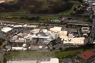
Porirua, a city in the Wellington Region of the North Island of New Zealand, is one of the four cities that constitute the Wellington metropolitan area. The name 'Porirua' is a corruption of 'Pari-rua', meaning "the tide sweeping up both reaches". It almost completely surrounds Porirua Harbour at the southern end of the Kapiti Coast. As of June 2022 Porirua had a population of 60,200.

<span class="mw-page-title-main">Plimmerton</span> Suburb of Porirua in New Zealand

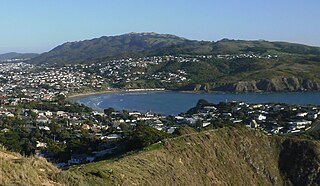
The suburb of Plimmerton lies in the northwest part of the city of Porirua in New Zealand, adjacent to some of the city's more congenial beaches. State Highway 59 and the North Island Main Trunk railway line pass just east of the main shopping and residential area.

<span class="mw-page-title-main">Ngāti Toa</span> Māori iwi in New Zealand

Ngāti Toa, Ngāti Toarangatira or Ngāti Toa Rangatira, is a Māori iwi (tribe) based in the southern North Island and in the northern South Island of New Zealand. Its rohe extends from Whanganui in the north, Palmerston North in the east, and Kaikoura and Hokitika in the south. Ngāti Toa remains a small iwi with a population of only about 4500. It has four marae: Takapūwāhia and Hongoeka in Porirua City, and Whakatū and Wairau in the north of the South Island. Ngāti Toa's governing body has the name Te Rūnanga o Toa Rangatira.

<span class="mw-page-title-main">Porirua Harbour</span> Body of water

Te Awarua-o-Porirua Harbour, commonly known as Porirua Harbour, is a natural inlet in the south-western coast of the North Island of New Zealand.

<span class="mw-page-title-main">Tītahi Bay</span> Suburb of Porirua City in New Zealand

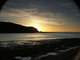
Tītahi Bay, a suburb of Porirua in the North Island of New Zealand, lies at the foot of a short peninsula on the west coast of the Porirua Harbour, to the north of Porirua city centre.

Wellington Regional Council, branded as Greater Wellington Regional Council, is the regional council overseeing the Wellington Region of New Zealand's lower North Island. It is responsible for public transport under the brand Metlink, environmental and flood protection, and the region's water supply.

<span class="mw-page-title-main">Regional parks of New Zealand</span>

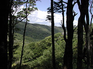
Regional parks of New Zealand are protected areas administered by regional councils, the top tier of local government.

<span class="mw-page-title-main">Te Āti Awa</span> Māori iwi in New Zealand

Te Āti Awa is a Māori iwi with traditional bases in the Taranaki and Wellington regions of New Zealand. Approximately 17,000 people registered their affiliation to Te Āti Awa in 2001, with around 10,000 in Taranaki, 2,000 in Wellington and around 5,000 of unspecified regional location.

<span class="mw-page-title-main">Karehana Bay</span>

Karehana Bay is a bay and nearby residential area at the western end of Plimmerton, a northern coastal locality of Porirua. It is located near the entrance to the Porirua Harbour, to the south-east of Hongoeka. It is about 5 minutes drive to Karehana Bay from the State Highway 59 turnoff to Plimmerton. The area looks out towards Mana Island and across Cook Strait to the South Island.

<span class="mw-page-title-main">Whitireia New Zealand</span> Education institute in New Zealand

Whitireia New Zealand, previously called Whitireia Community Polytechnic and Parumoana Community College, is a government-owned and funded tertiary education institute in New Zealand. It was established in 1986 on the shores of Porirua Harbour and today has 7,500 students, with campuses in Auckland, Wellington, Petone and Porirua.

<span class="mw-page-title-main">Battle Hill Farm Forest Park</span>

Battle Hill Farm Forest Park is a regional park near Paekakariki, in the Kapiti Coast District and Wellington Region of New Zealand's lower North Island.

<span class="mw-page-title-main">Belmont Regional Park</span>

Belmont Regional Park is a regional park located between Lower Hutt and Porirua, in the Wellington Region at the southern end of New Zealand's North Island. It is administered by Wellington Regional Council.

<span class="mw-page-title-main">East Harbour Regional Park</span>

East Harbour Regional Park is a regional park stretching from Baring Head along the east side of the Wellington Harbour along the east side of Eastbourne. It is located in Lower Hutt City, in the Wellington Region of New Zealand's North Island.

<span class="mw-page-title-main">Kaitoke Regional Park</span>

Kaitoke Regional Park is regional park located at Kaitoke, northeast of Upper Hutt, in the Wellington Region of New Zealand's southern North Island. It is administered by Wellington Regional Council, alongside the adjacent regional park of Hutt Water Collection Area.

<span class="mw-page-title-main">Baring Head</span>

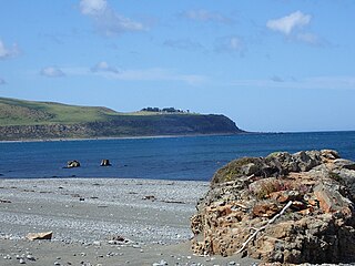
Baring Head is a headland, located between Wellington Harbour and Palliser Bay at the southern end of the North Island of New Zealand. It marks the southern end of Fitzroy Bay.

Hongoeka is a community in the city of Porirua in New Zealand. It is northwest of Plimmerton and adjacent to Hongoeka Bay. It extends from an urupā (cemetery) boundary at the end of Moana Road, to Haukōpua. A residential area is situated in Hongoeka Bay itself and takes up flat land and lower hillsides. It is bordered by bush clad hills and farmland, and looks out over a broad sweep of rugged coastline towards Whitireia and Mana Island, and to the South Island beyond.

Takapūwāhia, also known as Porirua Pa, was originally built on one of the oldest settlements in the Porirua basin called Te Urukahika, a small hamlet located on the western shore of Porirua harbour in the lower (southern) North Island of New Zealand.

<span class="mw-page-title-main">Te Whakaruruhau o Ngā Reo Irirangi Māori</span> New Zealand indigenous radio network

Te Whakaruruhau o Ngā Reo Irirangi Māori is a New Zealand radio network consisting of radio stations that serve the country's indigenous Māori population. Most stations receive contestable government funding from Te Māngai Pāho, the Māori Broadcast Funding Agency, to operate on behalf of affiliated iwi (tribes) or hapū (sub-tribes). Under their funding agreement, the stations must produce programmes in the Māori language, and must actively promote Māori culture.

<span class="mw-page-title-main">Pakuratahi Forest</span>

Pakuratahi Forest is a regional park located in Upper Hutt in the Wellington Region at the southern end of New Zealand's North Island. It is administered by Wellington Regional Council.

References

  1. 1 2 3 4 5 6 7 8 "Whitireia Park". gw.govt.nz. Wellington Regional Council.
  2. 1 2 3 4 5 "Whitireia Park Environment" (PDF). gw.govt.nz. Wellington Regional Council.
  3. 1 2 3 4 5 6 "History of Whitireia Park". gw.govt.nz. Wellington Regional Council.
  4. Walton, A (2002). "An archaeological survey of Whitireia Park, Porirua" (PDF). doc.govt.nz. Department of Conservation.
  5. 1 2 3 "Help us shape the future of Whitireia Park". windsurfingnz.org. Windsurfing New Zealand.
  6. Dando, Kris (8 April 2016). "Whitireia Park fire flashback". stuff.co.nz. Dominion Post.
  7. 1 2 3 "Whitireia Park Recreation". gw.govt.nz. Wellington Regional Council.
  8. Fallon, Virginia (17 February 2017). "On a short leash: pooches freedom curtailed at Porirua beach". stuff.co.nz. Dominion Post.
  9. Nicoll, Jared (1 August 2018). "Radio NZ tuning into property possibilities for Porirua's Whitireia Park". stuff.co.nz. Dominion Post.
  10. Campbell, Georgina (20 July 2021). "Sewage leaks into Porirua Harbour, coastal walking track closed". New Zealand Media and Entertainment. New Zealand Herald.
  11. "Our top walks". poriruacity.govt.nz. Porirua City Council.
  12. "Back Your Backyard: 12-hour guide to Porirua". stuff.co.nz. Dominion Post. 6 July 2020.