
Porirua, a city in the Wellington Region of the North Island of New Zealand, is one of the four cities that constitute the Wellington metropolitan area. The name 'Porirua' is a corruption of 'Pari-rua', meaning "the tide sweeping up both reaches". It almost completely surrounds Porirua Harbour at the southern end of the Kāpiti Coast. As of 2023, Porirua has a population of 62,400 people, and is a diverse city with 26.5% of the population identifying as Pasifika and 23.0% of the population identifying as Māori.
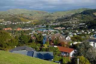
Whitby, a large suburb of Porirua City, New Zealand, located along much of the southern shore of the Pauatahanui Inlet of Porirua Harbour was comprehensively planned in the 1960s and it has been continuously developed since, with current landscaping and expansion in the hills behind the eastern part of Whitby to facilitate the future growth of the suburb.

The suburb of Plimmerton lies in the northwest part of the city of Porirua in New Zealand, adjacent to some of the city's more congenial beaches. State Highway 59 and the North Island Main Trunk railway line pass just east of the main shopping and residential area.

Pukerua Bay is a small seaside suburb at the southern end of the Kāpiti Coast, New Zealand. In local government terms it is the northernmost suburb of Porirua City, in the Wellington Region. It is 12 km north of the Porirua City Centre on State Highway 59, and 30 km north of central Wellington. In Māori, the words puke rua literally mean two hills but it is not clear to which hills the name refers.

Camborne, New Zealand is a hilltop and seaside suburb of Porirua.

Tawa is the northernmost suburb within the Wellington city boundary, located roughly 15 km north of Wellington's CBD between Churton Park and Porirua in the North Island of New Zealand. It takes its name from the broadleaf tree, which was once prolific throughout the area, although its most famous tree is the Bucket Tree, a large macrocarpa with the topiary of an upside-down bucket. Tawa is also known for its large number of churches, representing a wide range of Christian denominations.

Te Awarua-o-Porirua Harbour, commonly known as Porirua Harbour, is a natural inlet in the south-western coast of the North Island of New Zealand.
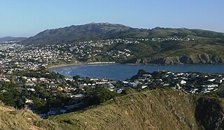
Tītahi Bay is a suburb of Porirua in metropolitan Wellington, in the lower North Island of New Zealand. It lies at the foot of a short peninsula on the west coast of the Porirua Harbour, to the north of Porirua city centre.

Fort Parramatta was the name given to a fort north of Wellington, New Zealand, in the 1840s. It was built 1846-47. The earthquakes of 1848 and 1855 reduced the building to a ruinous condition. The remains of the fort are still visible on the Ngatitoa Domain in Porirua City, but the surrounding suburb name has been changed to "Paremata".

Pāuatahanui is a village in New Zealand's North Island. It is at the far eastern end of what was known as the Pāuatahanui Inlet, an arm of the Porirua Harbour, northeast of Wellington. In local government terms, Pāuatahanui is part of the Northern Ward of Porirua City.

Metlink's Kapiti Line is the electrified southern portion of the North Island Main Trunk railway between New Zealand's capital city, Wellington, and Waikanae on the Kāpiti Coast, operated by Transdev Wellington on behalf of Greater Wellington Regional Council. Trains run frequently every day, with stops at 16 stations. Until 20 February 2011 it was known as the Paraparaumu Line.

Mana is a locality of Porirua City in New Zealand, part of the Suburb of Paremata. It is a narrow isthmus bounded to the west by the entrance to Porirua Harbour, and to the east by the Pauatahanui inlet of the Porirua Harbour. Mana Island lies about three kilometres west of the isthmus.

Karehana Bay is a bay and nearby residential area at the western end of Plimmerton, a northern coastal locality of Porirua. It is located near the entrance to the Porirua Harbour, to the south-east of Hongoeka. It is about 5 minutes drive to Karehana Bay from the State Highway 59 turnoff to Plimmerton. The area looks out towards Mana Island and across Cook Strait to the South Island.

Paremata railway station on the Kapiti Line section of the North Island Main Trunk Railway (NIMT) in Paremata in the city of Porirua, New Zealand, is part of the Wellington Region's Metlink suburban rail network.
Hongoeka is a community in the city of Porirua in New Zealand. It is northwest of Plimmerton and adjacent to Hongoeka Bay. It extends from an urupā (cemetery) boundary at the end of Moana Road, to Haukōpua. A residential area is situated in Hongoeka Bay itself and takes up flat land and lower hillsides. It is bordered by bush clad hills and farmland, and looks out over a broad sweep of rugged coastline towards Whitireia and Mana Island, and to the South Island beyond.
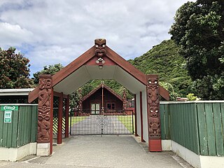
Takapūwāhia, also known as Porirua Pa, was originally built on one of the oldest settlements in the Porirua basin — Te Urukahika, a small hamlet located on the western shore of Porirua harbour in the lower North Island of New Zealand.
The Haywards–Plimmerton Line was a railway development proposed several times between 1879 and the 1960s to connect the Hutt Valley and Porirua areas of Wellington via Haywards.
Paremata-Plimmerton Rugby Football Club is a rugby union club based in Paremata, a northern suburb of Porirua, New Zealand.
State Highway 58 (SH 58) is a New Zealand state highway in the Wellington Region linking the Hutt Valley to Porirua City.
State Highway 59 (SH 59) is a New Zealand state highway in the Wellington Region linking Mackays Crossing to Linden. It came into existence on 7 December 2021, prior to the opening of the Transmission Gully Motorway, and consists of the former route of State Highway 1 between Mackays Crossing and Linden.


