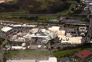
Porirua, a city in the Wellington Region of the North Island of New Zealand, is one of the four cities that constitute the Wellington metropolitan area. The name 'Porirua' is a corruption of 'Pari-rua', meaning "the tide sweeping up both reaches". It almost completely surrounds Porirua Harbour at the southern end of the Kapiti Coast. As of June 2022 Porirua had a population of 60,200.
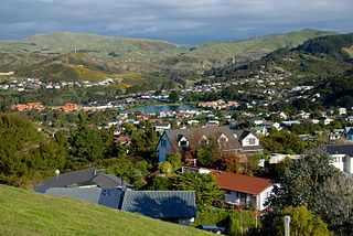
Whitby, a large suburb of Porirua City, New Zealand, located along much of the southern shore of the Pauatahanui Inlet of Porirua Harbour was comprehensively planned in the 1960s and it has been continuously developed since, with current landscaping and expansion in the hills behind the eastern part of Whitby to facilitate the future growth of the suburb.

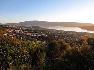
The suburb of Plimmerton lies in the northwest part of the city of Porirua in New Zealand, adjacent to some of the city's more congenial beaches. State Highway 59 and the North Island Main Trunk railway line pass just east of the main shopping and residential area.

Heritage New Zealand Pouhere Taonga is a Crown entity with a membership of around 20,000 people that advocates for the protection of ancestral sites and heritage buildings in New Zealand. It was set up through the Historic Places Act 1954 with a mission to "...promote the identification, protection, preservation and conservation of the historical and cultural heritage of New Zealand" and is an autonomous Crown entity. Its current enabling legislation is the Heritage New Zealand Pouhere Taonga Act 2014.

Pāuatahanui is a village in New Zealand's North Island. It is at the far eastern end of what was known as the Pāuatahanui Inlet, an arm of the Porirua Harbour, northeast of Wellington. In local government terms, Pāuatahanui is part of the Northern Ward of Porirua City.
Papakōwhai is a suburb of Porirua City. It lies approximately 22 kilometres (14 mi) north of Wellington in New Zealand.

The Royal New Zealand Police College (RNZPC) is the central training institution for police recruits and police officers in New Zealand. It is located at Papakowhai, approximately 2 km north of Porirua City.

Aotea Lagoon is an artificial lagoon surrounded by a 7-hectare (17-acre) public park in the Papakowhai suburb of Porirua, North Island, New Zealand. Aotea and two nearby lagoons were created when major arterial transport links were realigned from the natural coastline to land reclaimed from Porirua Harbour.

Alfred de Bathe Brandon was a 19th-century New Zealand politician.

Paremata railway station on the Kapiti Line section of the North Island Main Trunk Railway (NIMT) in Paremata in the city of Porirua, New Zealand, is part of the Wellington Region's Metlink suburban rail network.

Nicholas Oliver Leggett is a former New Zealand politician and, as of 2016, a member of the New Zealand National Party. He was the previous Mayor of Porirua, and at the time of his election in October 2010, he was the youngest mayor in New Zealand.

Glenside is a suburb of Wellington, New Zealand. It is bounded by Tawa to the North, Churton Park to the West/South and Grenada across the motorway to the East.

Taylor-Stace Cottage, built in 1847, is the oldest surviving house of European origin in the Wellington region of New Zealand. The cottage is classified as a Category I historic place by the New Zealand Historic Places Trust. Taylor-Stace Cottage was built by immigrants William and Anne Taylor, who had come to New Zealand in 1840.
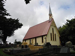
St Alban's Church, built in 1898, in Pauatahanui, Porirua is the second church to be built in Pauatahanui, New Zealand. St Alban's Church was listed by the New Zealand Historic Places Trust as a Category 2 historic place in 1983.
The Haywards–Plimmerton Line was a railway development proposed several times between 1879 and the 1960s to connect the Hutt Valley and Porirua areas of Wellington via Haywards.

Gear Homestead, named Okowai by its owner James Gear, is a historic building in Porirua, New Zealand. It was listed by the New Zealand Historic Places Trust as a Category 2 historic place in 1983.
Homebush is a settlement in the Canterbury region of New Zealand. It has had a long association with the pioneering Deans family.
State Highway 59 (SH 59) is a New Zealand state highway in the Wellington Region linking Mackays Crossing to Linden. It came into existence on 7 December 2021, prior to the opening of the Transmission Gully Motorway and consists of the former route of State Highway 1 between Mackays Crossing and Linden.

Homebush Homestead is building in Homebush, New Zealand, belonging to the early pioneering Deans family. The previous homestead was severely damaged during the 2010 Canterbury earthquake. It was demolished soon after. It has since been replaced by a new building, designed by Athfield Architects Limited.
