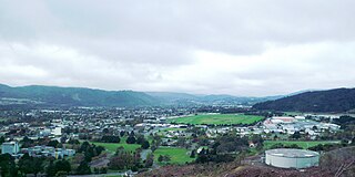
Upper Hutt is a city in the Wellington Region of New Zealand and one of the four cities that constitute the Wellington metropolitan area.

Te Awa Kairangi / Hutt River flows through the southern North Island of New Zealand. It flows south-west from the southern Tararua Range for 56 kilometres (35 mi), forming a number of fertile floodplains, including Kaitoke, central Upper Hutt and Lower Hutt.

Kaitoke, part of Upper Hutt City, is a locality in the southern North Island of New Zealand. It is located at the northern end of the Hutt Valley, 45 kilometres northeast of Wellington City and six kilometres from the northern end of the Upper Hutt urban area. It also lies at the southern end of the Tararua Ranges.

The Rimutaka Incline was a 3-mile-long (4.8 km), 3 ft 6 in gauge railway line on an average grade of 1-in-15 using the Fell system between Summit and Cross Creek stations on the Wairarapa side of the original Wairarapa Line in the Wairarapa district of New Zealand. The term "Rimutaka Incline" is sometimes used incorrectly to refer to other parts or all of the closed and deviated section of the Wairarapa Line between Upper Hutt and Speedy's Crossing, near Featherston. The incline formation is now part of the Remutaka Rail Trail.

The Remutaka Range is the southernmost range of a mountain chain in the lower North Island of New Zealand. The chain continues north into the Tararua, then Ruahine Ranges, running parallel with the east coast between Wellington and East Cape.
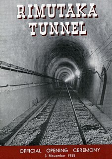
The Remutaka Tunnel is a railway tunnel through New Zealand's Remutaka Range, between Maymorn, near Upper Hutt, and Featherston, on the Wairarapa Line.
Te Mārua is the easternmost urban suburb of Upper Hutt. For reasons of location and distance from the city, the area is often classified as rural. Te Mārua is well known for its Plateau Reserve where remnants of the old Rimutaka Railway path can be found, which now form part of a historic walk. Mt Climie, the highest peak of the Remutaka Range, can also be reached from the reserve. The suburb is also the location of the Wellington Speedway, a nationally important venue for stock car racing, and of the Wellington Naturist Club's club grounds, venue of the historic 2016 World Congress of the International Naturist Federation.

The Wairarapa Line is a secondary railway line in the south-east of the North Island of New Zealand. The line runs for 172 kilometres (107 mi), connects the capital city Wellington with the Palmerston North - Gisborne Line at Woodville, via Lower Hutt, Upper Hutt and Masterton.
Wellington Regional Council, branded as Greater Wellington Regional Council, is the regional council overseeing the Wellington Region of New Zealand's lower North Island. It is responsible for public transport under the brand Metlink, environmental and flood protection, and the region's water supply.
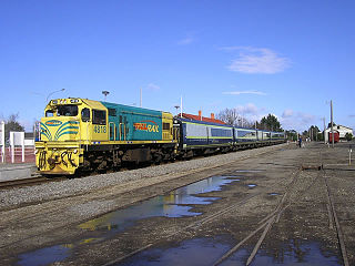
The Wairarapa Connection is a New Zealand interurban commuter rail service along the Wairarapa Line between Masterton, the largest town in the Wairarapa, and Wellington. It is operated by Wellington suburban operator Transdev under contract from the Greater Wellington Regional Council. It is a diesel-hauled carriage service, introduced by the New Zealand Railways Department in 1964 after passenger demand between Masterton to Wellington exceeded the capacity of the diesel railcars then used.
Maymorn, a rural area of Upper Hutt city in the Wellington region of New Zealand, consists of Rural Hill and Rural Valley Floor zones. The New Zealand census treats Maymorn as part of Te Mārua for statistical purposes. The usual resident 2013 population of the Te Mārua area was 1,152. The area has a tranquil setting and consists of lifestyle blocks and farms surrounded by hills that are usually covered with a dusting of snow in the winter.

Maymorn railway station is a twin platform, rural request stop railway station serving the small settlement of Maymorn on the Maymorn Plateau, east of Upper Hutt, in New Zealand’s North Island. It is served by the Wairarapa Connection, and sees five services each way Monday to Thursday, six on Friday and two on Saturday and Sunday.

Remutaka is an electorate returning one member to the New Zealand House of Representatives. The current representative is Chris Hipkins, a member of the Labour Party who has represented the seat since the 2008 New Zealand general election.
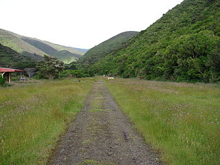
The Remutaka Rail Trail is a walking and cycling track in the North Island of New Zealand. It runs between Maymorn and Cross Creek, and follows 22 kilometres (14 mi) of the original route of the Wairarapa Line over the Remutaka Range between the Mangaroa Valley and the Wairarapa, including the world-famous Rimutaka Incline. Parts of the trail are also used by vehicles both from the regional council and from forestry companies with tree plantations in the area; members of the public have limited vehicular access from the Kaitoke end to a car park, go-kart track and gun range. Access is also granted by permission to horse riders. Touring coaches have been used upon occasion to convey tourists and other visitors to various parts of the route.

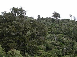
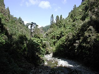
Remutaka Forest Park is a protected area near Wellington, New Zealand. Popular access points are south of Wainuiomata and in the upper Hutt Valley. The park covers 220 square kilometres (85 sq mi), encompassing the Catchpool Valley and the Ōrongorongo Valley at the southern end of the Remutaka Range. Established in 1972, the park contains several short walks and six huts that can be booked and accessed by longer bush tramps. The park is one part of several local conservation areas, as it borders the Pakuratahi Forest and the Tararua Range.

Belmont Regional Park is a regional park located between Lower Hutt and Porirua, in the Wellington Region at the southern end of New Zealand's North Island. It is administered by Wellington Regional Council.

Kaitoke Regional Park is regional park located at Kaitoke, northeast of Upper Hutt, in the Wellington Region of New Zealand's southern North Island. It is administered by Wellington Regional Council, alongside the adjacent regional park of Hutt Water Collection Area.
Akatarawa Forest is a regional park in the Upper Hutt within the Wellington Region at the southern tip of the North Island of New Zealand. It encompasses 15,000 hectares of native and plantation forest. It includes the headwaters of the Maungakotukutuku Steam, Akatarawa River West and the Whakatikei River.

Wainuiomata Regional Park is a regional park located near Wainuiomata, Lower Hutt in the Wellington Region of New Zealand. It is administered by Wellington Regional Council. The name of the park was changed from Wainuiomata Recreation Area to Wainuiomata Regional Park in January 2022.
Wainuiomata Water Collection Area is a regional park located near Wainuiomata, Lower Hutt in the Wellington Region at the southern end of New Zealand's North Island. It is administered by Wellington Regional Council, for exclusive use by Wellington Water as a water catchment reserve. The park covers the catchments of the Wainuiomata River and the Ōrongorongo River. It adjoins Remutaka Forest Park and Wainuiomata Recreation Area.