
The national parks of New Zealand are protected natural areas administered by the Department of Conservation (DOC). Although the national parks contain some of New Zealand's most beautiful scenery, the first few established were all focused on mountain scenery. Since the 1980s the focus has been on developing a more diverse representation of New Zealand landscapes. The parks are all culturally significant and many also contain historic features. Tongariro National Park is one of the World Heritage Sites that are of both cultural and natural significance, while four of the South Island national parks form Te Wahipounamu, another World Heritage Site. There are currently 13 national parks; a 14th, Te Urewera National Park, was disestablished in 2014.

Fiordland is a geographic region of New Zealand in the south-western corner of the South Island, comprising the westernmost third of Southland. Most of Fiordland is dominated by the steep sides of the snow-capped Southern Alps, deep lakes, and its steep, glacier-carved and now ocean-flooded western valleys. The name "Fiordland" comes from a variant spelling of the Scandinavian word for this type of steep valley, "fjord". The area of Fiordland is dominated by, and very roughly coterminous with, Fiordland National Park, New Zealand's largest National Park.

The Department of Conservation is the public service department of New Zealand charged with the conservation of New Zealand's natural and historical heritage.

Fiordland National Park occupies the southwest corner of the South Island of New Zealand. It is by far the largest of the 13 national parks in New Zealand, with an area of 12,607 square kilometres (4,868 sq mi), and a major part of the Te Wahipounamu World Heritage site. The park is administered by the Department of Conservation.

Nelson Lakes National Park is in the South Island of New Zealand, at the northern end of the Southern Alps. It was formed after the passing of the National Parks Act in 1952. It was created in 1956. The park contains beech forests, multiple lakes, snow covered mountains and valleys created by glaciers during the ice ages.
Arthur's Pass National Park is located in the South Island of New Zealand and covers 1,185 km2 of mostly mountainous terrain. Adjacent to it lies Craigieburn Forest Park.
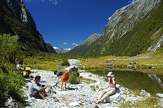
The Milford Track is a hiking route in New Zealand, located amidst mountains and temperate rain forest in Fiordland National Park in the southwest of the South Island. The 53.5 km hike starts at Glade Wharf at the head of Lake Te Anau and finishes in Milford Sound at Sandfly Point, traversing rainforests, wetlands, and an alpine pass.

The Kepler Track is a 60 km (37 mi) circular hiking track which travels through the landscape of the South Island of New Zealand and is situated near the town of Te Anau. The track passes through many landscapes of the Fiordland National Park such as rocky mountain ridges, tall mossy forests, lake shores, deep gorges, rare wetlands and rivers. Like the mountains it traverses, the track is named after Johannes Kepler. The track is one of the New Zealand Great Walks and is administered by the Department of Conservation (DOC).
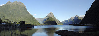
Transport in Milford Sound in New Zealand is characterised by the remoteness of the area in which it is located. As a popular tourism destination in the South Island, Milford Sound and the village of the same name receive very large numbers of visitors. These tend to arrive and depart within just a few hours each day, as there is little accommodation at the Sound, leading to strong demand peaks for tourism services during the noon and early afternoon period. The journey from Te Anau is rated as one of the most photographic drives of the world.

Whirinaki Te Pua-a-Tāne Conservation Park is a publicly accessible conservation park in the North Island of New Zealand. The park is centered on the town of Minginui and part of the eastern boundary flanks Te Urewera. The Whirinaki Forest is one of the world's last prehistoric rainforests.

Pureora Forest Park is a 760-square-kilometre (290 sq mi) protected area in the North Island of New Zealand. Within its rich rainforest are an abundance of 1,000-year-old podocarp trees. It is "recognised as one of the finest rain forests in the world". Established in 1978, after a series of protests and tree sittings, the park is one of the largest intact tracts of native forest in the North Island and has high conservation value due to the variety of plant life and animal habitats. New Zealand's largest totara tree is located nearby on private land.

The Southland montane grasslands, also known as the South Island montane grasslands, is a montane grasslands and shrublands ecoregion on New Zealand’s South Island. The ecoregion covers the middle portion of the Southern Alps, and includes extensive alpine grasslands, fellfields, and montane forests.
Green Lake is a lake in Hunter Mountains in the Southland Region of New Zealand located to the north of Lake Monowai. The lake has no surface outlets but probably feeds several streams draining to lake Monowai via springs. The lake is a basin in the debris of the Green Lake Landslide, which is the largest known above-sea-level landslide on earth. Steep escarpments on the north and east sides of the lake form the head scarp of the landslide, which has an estimated volume of 27 cubic kilometres (6.5 cu mi).

Southland is New Zealand's southernmost region. It consists mainly of the southwestern portion of the South Island and Stewart Island/Rakiura. It includes Southland District, Gore District and the city of Invercargill. The region covers over 3.1 million hectares and spans over 3,400 km of coast.

Pianoa is a monotypic genus of large-clawed spiders endemic to New Zealand. It contains a single species, Pianoa isolata, known commonly as the piano flat spider.

Goodnature is a New Zealand manufacturer of lethal traps for animals such as stoats, rats, mice and possums. It was founded by Robbie van Dam and Craig Bond in 2005, and sells automatic self-resetting pest control traps and accessories.

Catlins Conservation Park is a protected area in the Otago region of New Zealand, covering 53,041 hectares in The Catlins, within the Clutha District.

Hakatere Conservation Park is a protected area in Mid Canterbury, New Zealand. It includes 60,000 hectares and offers an array of recreational activities. The park is located in the Ashburton Lakes District between the Rakaia River and Rangitata River.
Whakarewarewa Conservation Park or Whakarewarewa Forest Park is a mainland island in the Bay of Plenty Region of New Zealand. It lies close to SH 30 to the southwest of Rotorua.

Hikurangi Marine Reserve is a marine reserve off the coast of the Kaikoura District, in the Canterbury Region of New Zealand's South Island. Is is the largest and deepest marine reserve in New Zealand.

