The Hutt Valley is the large area of fairly flat land in the Hutt River valley in the Wellington region of New Zealand. Like the river that flows through it, it takes its name from Sir William Hutt, a director of the New Zealand Company in early colonial New Zealand.
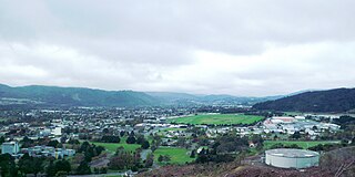
Upper Hutt is a city in the Wellington Region of New Zealand and one of the four cities that constitute the Wellington metropolitan area.
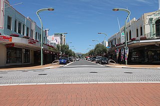
Heretaunga Street is the main arterial road through Hastings, New Zealand. The street forms the heart of the Central Business District of Hastings City across six blocks numbered 100, 200, and 300 Blocks with the railway line dividing the blocks by East and West. The name Heretaunga is taken from the name of the Māori Land Block on which Hastings was established in 1873.
Sydney Walter Josland was a New Zealand bacteriologist who specialised in research into Leptospirosis, Salmonella and the control of diseases in animals.

Upper Hutt College is a state co-educational secondary school located in Trentham in the city of Upper Hutt, New Zealand. The school opened in 1962 as the city's second state secondary school, supplementing Heretaunga College in Wallaceville. As of August 2024, the school has a roll of 1148 students from years 9 to 13.
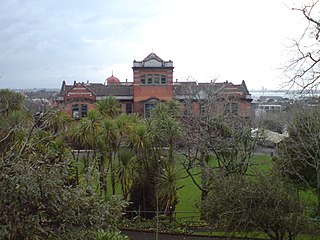
Auckland Girls' Grammar School (AGGS) is a New Zealand secondary school for girls located in Newton, in the Auckland central business district. Established in 1878 as Auckland Girls' High School, it is one of the oldest secondary institutions in the country. The school closed its site temporarily in 1888 due to financial difficulties and classes for girls were held at Auckland Grammar School until the girls' school moved to new premises in Howe Street in 1909 and the name of the school changed to Auckland Girls' Grammar School. The school received the Goodman Fielder awards for School and Secondary School of the year in 2000.

Heretaunga College is a state coeducational secondary school located in Upper Hutt, New Zealand. The school has approximately 848 students from Years 9 to 13.
Heretaunga is a suburb of the city of Upper Hutt, located in the lower (southern) North Island of New Zealand. Heretaunga adjoins the suburb of Silverstream to its southwest and the two are commonly thought of associated with each other. To the northeast lies Trentham. The Heretaunga Railway Station on the Hutt Valley Line serves the suburb.

Tōtara Park is a suburb of Upper Hutt, New Zealand, located 2 km northeast of the city centre. It is accessed via the Tōtara Park Bridge which crosses the Hutt River, connecting it to State Highway 2 and the main Upper Hutt urban area. It was popular in the 1970s and 1980s for families moving into the Upper Hutt area.
The Wellington Institute of Technology, also known as WelTec, is a New Zealand polytechnic based in Petone, Lower Hutt. WelTec was formed in 2001 by an amalgamation between the Central Institute of Technology and the Hutt Valley Polytechnic In 2020, WelTec, along with 15 other national polytechnics, became subsidiaries of Te Pūkenga – New Zealand Institute of Skills and Technology.

Wallaceville railway station is a suburban railway station serving Wallaceville in Upper Hutt, New Zealand. The station is located on the Hutt Valley section of the Wairarapa Line, 31.3 km (19.4 mi) north of Wellington, and is served by Metlink on behalf of the Greater Wellington Regional Council. Trains between Upper Hutt and Wellington stop at Wallaceville.

Heretaunga is a former New Zealand parliamentary electorate, in the city of Upper Hutt, that existed from 1954 until 1996.

Lower Hutt is a city in the Wellington Region of New Zealand. Administered by the Hutt City Council, it is one of the four cities that constitute the Wellington metropolitan area.

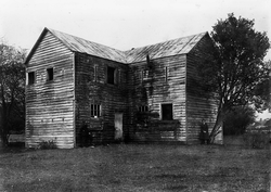
The Upper Hutt Blockhouse also known as the Wallaceville Blockhouse is a 19th-century American-style military blockhouse situated in Upper Hutt, New Zealand. One of very few such blockhouses built in New Zealand, it is preserved as a Category I historic place. It was built in late 1860 as part of a larger Stockade and was one of two Blockhouses and Stockades built in the Hutt Valley that year. It was occupied by the Hutt Battalion of the Wellington Militia from December 1860 to May 1861 without coming under hostile attack.

Ira James Cunningham (1905–1971) was a New Zealand researcher in trace element nutrition and animal science. He is best remembered as a past president of the New Zealand Veterinary Association.

Golder Cottage is one of the oldest surviving colonial houses in Upper Hutt, New Zealand. The house is used as a museum of colonial domestic life.

Moawhango is a rural community in the northern part of Rangitikei District of the Manawatū-Whanganui region of New Zealand's North Island. It is situated 19 km north of Taihape and 91 km northeast of Marton. Nearby Moawhango are located Moawhango River and Lake Moawhango.
Tauranga Central is a suburb and the central business district of Tauranga, in the Bay of Plenty Region of New Zealand's North Island.

New Zealand performing arts venues are places in New Zealand that are set up to host performing arts and music events such as theatre, dance and concerts.