Piopiotahi (Milford Sound) Marine Reserve

Last updated

Piopiotahi (Milford Sound) Marine Reserve
Cruise on Milford sound (5796043020).jpg
Milford Sound, with the marine reserve on the northern (right) side
NZ-SI plain map.png
Disc Plain red.svg
Location Fiordland, New Zealand
Coordinates 44°38′53″S167°54′20″E / 44.64806°S 167.90556°E / -44.64806; 167.90556
Area690 hectares (1,700 acres)
Established1993
Governing body Department of Conservation

Piopiotahi (Milford Sound) Marine Reserve is a marine reserve covering an area of 690 hectares (1,700 acres) in the Milford Sound / Piopiotahi, in Fiordland on New Zealand's South Island. It was established in 1993 and is administered by the Department of Conservation. [1] [2]

Contents

The marine reserve spans 16 kilometres (9.9 mi) and 690 hectares (1,700 acres) of the northern half of Milford Sound, stretching from the Milford Sound Village to Dale Point where the sound meets the Tasman Sea. [1] Fishing restrictions also apply to the other half of the Sound. [3]

Geography and ecology

Most of the Sound is a mostly deep muddy fiord basin, with deep reefs and some shallow rock walls along the shore. Delicate deep water invertebrates encrusting tubeworms, sea sponges, soft corals, colonial sea squirts, black coral and anemones are fixed to a very steep rock-wall on the inner northern side of the Sound. [1]

Closer to the sea, schools of butterfly perch, rock lobster and reef fish live alongside octopus, stingrays, seals and the odd bottlenose dolphin. [1]

In the fiords, heavy rainfall runs off from the surrounding mountains creates a permanent freshwater layer to about 5 centimetres (2.0 in) to 10 metres (33 ft) below the surface. A layer of calm, clear and warm seawater provides a habitat for a range of sponges, corals and fish to about 40 metres (130 ft) below the surface. Further down, tannins from vegetation run-off make the sea too dark to support most marine life. [4]

The fiords are also a habitat for black corals and brittle stars that live in their branches. [5] There are also brachiopods, aihe (bottlenose dolphins), kekono (New Zealand fur seals), tawaki (Fiordland crested penguins) and kororā (little blue penguins). [4]

History

The reserve was established in 1993, [2] receiving legal recognition on 25 October of that year. [6]

The Māori name of the reserve, Piopiotahi, translates to "one native thrush". The now extinct piopio was a ground-feeding bird wiped out by pests like rats and stoats. [1]

The Ministry of Primary Industries, Fiordland Marine Guardians and other agencies are involved in protecting the marine reserve and stopping the spread of invasive seaweed. [4]

Research and commerce

Educational and scientific activities are encouraged, but must not disturb or endanger plants, animals or natural features. Scientific research requires a permit from the Department of Conservation. [4]

Recreation

A boat in the Milford Sound. Boat to Milford Sound - 2013.04 - panoramio.jpg
A boat in the Milford Sound.

Cruises and diving

The reserve is accessible from Te Anau via the Milford Road. [4] It is the most popular destination for cruises and diving excursionsm particularly because of its black coral and fiord landscape. [1]

Anchoring boats is banned in many areas to protect the particularly fragile species that can be damaged by anchors or swinging chains. Taking off and landing aircraft is permitted. [4]

The protected area can be viewed by diving or snorkelling, either independently or with a tourism or charter boat service. To protect the fragile environments, divers must follow the safety and care codes. [4] Divers can see stingrays, crayfish, octopus, seals, sharks and more than 100 species of fish. [1]

Fishing

There is a ban on fishing, and taking, killing or moving marine life and materials from within the reserve. However, members of Ngāi Tahu may remove pounamu provided they have the right authorisation, only collect by hand, keep disturbance to the site to a minimum, and only carry as much as they can in one trip. They may also collect deceased marine mammals and collect teeth and bones. [4]

Limited fishing is allowed outside of the marine reserve area. Tarakihi and hāpuku (grouper) can be found throughout the year, and yellowtail kingfish ( Seriola lalandi , known by the common name "amberjack" in North America), [7] tuna and broadbill can be caught during the right season with the right equipment. Blue cod cannot be caught from the internal waters but can be caught from the open sea outside the sound. [3]

A limited number of rock lobsters can be taken from the Sound. [8]

See also

Related Research Articles

<span class="mw-page-title-main">Milford Sound</span> Fiord in the southwest of New Zealands South Island

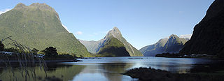
Milford Sound is a fiord in the south west of New Zealand's South Island within Fiordland National Park, Piopiotahi Marine Reserve, and the Te Wahipounamu World Heritage site. It has been judged the world's top travel destination in an international survey and is acclaimed as New Zealand's most famous tourist destination. Rudyard Kipling called it the eighth Wonder of the World. The fiord is most commonly accessed via road by tour coach, with the road terminating at a small village also called Milford Sound.

<span class="mw-page-title-main">Fiordland</span> Geographical region of New Zealand

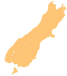
Fiordland is a geographical region of New Zealand in the south-western corner of the South Island, comprising the westernmost third of Southland. Most of Fiordland is dominated by the steep sides of the snow-capped Southern Alps, deep lakes, and its steep, glacier-carved and now ocean-flooded western valleys. The name "Fiordland" comes from a variant spelling of the Scandinavian word for this type of steep valley, "fjord". The area of Fiordland is dominated by, and very roughly coterminous with, Fiordland National Park, New Zealand's largest National Park.

<span class="mw-page-title-main">Fiordland National Park</span> National park on South Island of New Zealand

Fiordland National Park is a national park in the south-west corner of South Island of New Zealand. It is the largest of the 13 national parks in New Zealand, with an area covering 12,607 km2 (4,868 sq mi), and a major part of the Te Wāhipounamu a UNESCO World Heritage Site established in 1990. The park is administered by the Department of Conservation. The southern ranges of the Southern Alps cover most of Fiordland National Park, combined with the deep glacier-carved valleys.

<span class="mw-page-title-main">Doubtful Sound / Patea</span> Fiord in New Zealand

Doubtful Sound / Patea is a fiord in Fiordland, in the far south west of New Zealand. It is located in the same region as the smaller but more famous and accessible Milford Sound / Piopiotahi. It took second place after Milford Sound as New Zealand's most famous tourism destination.

<span class="mw-page-title-main">Yellowtail amberjack</span> Species of fish

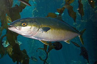
The yellowtail amberjack, yellowtail kingfish, hiramasa or great amberjack is a large fish found in the Southern Ocean. Although previously thought to be found in all oceans and seas, recent genetic analysis restricts S. lalandi proper to the Southern Hemisphere waters. However, they are found in Northern Hemisphere waters during certain times of the year. The fish was given its name by Monsieur de Lalande, a naturalist who first informed zoologist Achille Valenciennes of the existence of this species. His reason for the use of the word Seriola to name the fish is uncertain, but the second word lalandi was derived from his surname.

<span class="mw-page-title-main">Rakituma / Preservation Inlet</span> Fiord in the South Island of New Zealand

Rakituma / Preservation Inlet is the southernmost fiord in Fiordland National Park and lies on the southwest corner of the South Island of New Zealand. With an area of 93 square kilometres (36 sq mi), it is the fourth largest fiord in New Zealand, after Tamatea / Dusky Sound, Doubtful Sound / Patea, and the neighbouring Taiari / Chalky Inlet to the north. Rakituma was briefly the site of an attempted fishing and gold mining settlement at Cromarty during the 19th century, however this was quickly abandoned once the level of gold declined in relation to more promising fields elsewhere.

Hāwea / Bligh Sound is a fiord of the South Island of New Zealand. It is located in Fiordland, 30 kilometres southwest of Milford Sound, and is 15 kilometres in length. The fiord forms a crooked "Z" shape. Wild Natives River flows into the innermost arm, Bounty Haven.

<span class="mw-page-title-main">Charles Sound</span> Fiord of the South Island of New Zealand

Charles Sound is a fiord of the South Island of New Zealand. It is one of the fiords that form the coast of Fiordland.

Hawea Marine Reserve is a marine reserve covering an area of 411 hectares in Hāwea / Bligh Sound, in Fiordland on New Zealand's South Island. It was established in 2005 and is administered by the Department of Conservation.

Taiari / Chalky Inlet is one of the southernmost fiords in Fiordland, in the southwestern corner of New Zealand's South Island and part of Fiordland National Park. As with the neighbouring fiords of Tamatea / Dusky Sound to the north and Rakituma / Preservation Inlet to the south, Taiari / Chalky Inlet is a complex fiord with many channels and islands along its roughly 28 km (17 mi) length. Most notably, this includes the sections Moana-whenua-pōuri / Edwardson Sound and Te Korowhakaunu / Kanáris Sound, which split at Divide Head in the middle of Taiari and each extend for roughly 10 km (6.2 mi) inland in a V-shape.

Long Island-Kokomohua Marine Reserve is a marine reserve, in the Marlborough Region of New Zealand's South Island. It covers an area of 619 hectares at the entrance to the Queen Charlotte Sound in the Marlborough Sounds. It was the first marine reserve established on the South Island.

<span class="mw-page-title-main">Parininihi Marine Reserve</span>

Parininihi Marine Reserve is a marine reserve administered by the Department of Conservation, covering 1,800 hectares in the North Taranaki Bight. It is located offshore of the west coast of New Zealand's North Island, north-east of New Plymouth.

Kahukura Marine Reserve is a marine reserve covering an area of 464 hectares in Charles Sound, in Fiordland on New Zealand's South Island. It was established in 2005 and is administered by the Department of Conservation.

<span class="mw-page-title-main">Kutu Parera (Gaer Arm) Marine Reserve</span> Marine reserve in Fiordland, South Island, New Zealand

Kutu Parera Marine Reserve is a marine reserve covering an area of 433 hectares at Gaer Arm in the Bradshaw Sound of Fiordland on New Zealand's South Island. It was established in 2005 and is administered by the Department of Conservation.

<span class="mw-page-title-main">Taumoana (Five Finger Peninsula) Marine Reserve</span> Marine reserve in Fiordland on New Zealands South Island

Taumoana Marine Reserve is a marine reserve covering an area of 464 hectares in Fiordland on New Zealand's South Island. It was established in 2005 and is administered by the Department of Conservation. It is located next to the Five Fingers Peninsula, at the entrance to Tamatea / Dusky Sound.

<span class="mw-page-title-main">Te Tapuwae o Hua (Long Sound) Marine Reserve</span>

Te Tapuwae o Hua Marine Reserve is a marine reserve covering an area of 3,672 hectares in Te Awaroa / Long Sound in Fiordland on New Zealand's South Island. It was established in 2005 and is administered by the Department of Conservation.

<span class="mw-page-title-main">Moana Uta (Wet Jacket Arm) Marine Reserve</span> Marine reserve in New Zealand territorial waters

Moana Uta Marine Reserve is a marine reserve covering the entire length of Wet Jacket Arm in Fiordland on New Zealand's South Island, an area of 2,007 hectares. It was established in 2005 and is administered by the Department of Conservation.

<span class="mw-page-title-main">Taipari Roa (Elizabeth Island) Marine Reserve</span> Marine reserve in New Zealand territorial waters

Taipari Roa Marine Reserve is a marine reserve covering an area of 613 hectares around Elizabeth Island, in the inner Doubtful Sound / Patea of Fiordland on New Zealand's South Island. It was established in 2005 and is administered by the Department of Conservation.

Sutherland Sound Marine Reserve is a marine reserve covering an area of 449 hectares of Sutherland Sound / Sutherland Sound, in Fiordland on New Zealand's South Island. It was established in 2005 and is administered by the Department of Conservation.

<span class="mw-page-title-main">Te Awaatu Channel (The Gut) Marine Reserve</span>

Te Awaatu Channel Marine Reserve is a marine reserve covering an area of 93 hectares in Fiordland on New Zealand's South Island. It was established in 1993 and is administered by the Department of Conservation.

References

  1. 1 2 3 4 5 6 7 "Piopiotahi (Milford Sound) Marine Reserve". doc.govt.nz. Department of Conservation.
  2. 1 2 Hutching, Gerard. "Marine protected areas". Te Ara - the Encyclopedia of New Zealand . Ministry for Culture and Heritage.
  3. 1 2 "Fishing Milford Sounds". milford-sound.co.nz. Entrada Travel Group.
  4. 1 2 3 4 5 6 7 8 "Fiordland marine reserves". doc.govt.nz. Department of Conservation.
  5. "Fiordland Marine Reserves". aa.co.nz. Automobile Association of New Zealand.
  6. "Marine Reserve (Piopiotahi (Milford Sound)) Order 1993". legislation.govt.nz. New Zealand Government.
  7. Burgess, Allan; Marquand, Dick (19 November 2019). "Kingfish, Yellowtail - Seriola lalandi - How to catch yellowtail kingfish". Fishingmag.co.nz. Retrieved 23 February 2022.
  8. "Fiordland Recreational Fishing Rules". mpi.govt.nz. Ministry for Primary Industries.