Otago is a region of New Zealand located in the southern half of the South Island administered by the Otago Regional Council. It has an area of approximately 32,000 square kilometres (12,000 sq mi), making it the country's second largest local government region. Its population was 254,600 in June 2023.
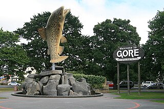
Gore is a town and district in the Southland region of the South Island of New Zealand. It has a resident population of 8,240 as of June 2023. Gore is known for its country music scene and hosts an annual country music festival. The town is also surrounded by farmland and is an important centre for agriculture in the region.

Invercargill is the southernmost and westernmost city in New Zealand, and one of the southernmost cities in the world. It is the commercial centre of the Southland region. The city lies in the heart of the wide expanse of the Southland Plains to the east of the Ōreti or New River some 18 km north of Bluff, which is the southernmost town in the South Island. It sits amid rich farmland that is bordered by large areas of conservation land and marine reserves, including Fiordland National Park covering the south-west corner of the South Island and the Catlins coastal region.
Winton is a rural town in Southland, New Zealand. It is located close to the east bank of the Ōreti River, 30 kilometres north of Invercargill and 50 kilometres south of Lumsden. The town is named after Thomas Winton, a local stockman who lived and farmed in the area in the 1850s. The district thrived with the development of sheep and fat-lamb farms in the early 1900s. Later, dairy farming became the staple economy, although the town has also seen sawmills, and flax and linen-flax industries.

Lumsden is a town in Southland, New Zealand. Lying in a gap in the surrounding hills, Lumsden is the location of a major junction on State Highway 6. Lumsden is 81 kilometres north of Invercargill, 106 kilometres south of Queenstown, 59 kilometres west of Gore and 77 kilometres east of Te Anau.
Makarewa is a small community north of Invercargill.
Te Tipua is a rural farming community in the eastern Southland region of New Zealand's South Island.
Nightcaps is a town in the Southland region of New Zealand's South Island. It is suggested that Nightcaps got its name either from the snow that is often seen on the Takitimu Mountains, or when early settlers observed fog on the hills known as the Nobbles. State Highway 96 passes through Nightcaps as it runs between Ohai and Winton. The town has a golf course and two primary schools that cater to students from Nightcaps, the surrounding rural area, and since the 2003 closure of its own school, Ohai.
Gorge Road is a locality in the Southland region of New Zealand's South Island. It is on the Southern Scenic Route and is situated on the western bank of the Mataura River. Nearby settlements include Ashers to the west, and across the Mataura, Pine Bush and Titiroa to the east.
Clifden, New Zealand is a small rural community on the Waiau River, Southland, New Zealand.
Otautau is a small farming, forestry and milling town located inland on the western edge of the Southland Plains of New Zealand on the banks of the Aparima River. Otautau is located approximately 40 kilometres (25 mi) north west of Invercargill. The average elevation of Otautau is 60 metres.
Waikaia, formerly known as Switzers, is a town in the Southland region of New Zealand's South Island. From 1909 until 1959, it was the terminus of the Waikaia Branch railway. The population in the 2013 census was 99, unchanged from the previous census in 2006.

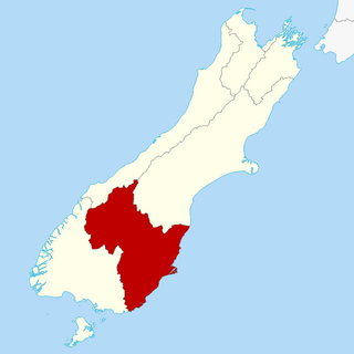
Southland is New Zealand's southernmost region. It consists of the southwestern portion of the South Island and includes Stewart Island. Southland is bordered by the culturally similar Otago Region to the north and east, and the West Coast Region in the extreme northwest. The region covers over 3.1 million hectares and spans 3,613 km of coastline. As of June 2023, Southland has a population of 103,900, making it the eleventh-most-populous New Zealand region, and the second-most sparsely populated. Approximately half of the region's population lives in Invercargill, Southland's only city.
Garston is a small settlement in northern Southland, in the South Island of New Zealand, located close to the region's boundary with Otago. It is the most inland settlement in New Zealand. It is situated south of Lake Wakatipu and close to the upper reaches of the Mataura River, between Kingston and Lumsden. Garston is connected to both Kingston and Lumsden by SH 6.

Kew is a suburb in the New Zealand city of Invercargill.
Glenham is a rural community in the Southland District and Southland Region of New Zealand.
Heddon Bush is a rural community in the Southland District and Southland Region of New Zealand.
Lochiel is a rural community in the Southland District and Southland Region of New Zealand.
Tuturau is a rural community in the Southland District and Southland Region of New Zealand.
