Related Research Articles
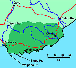
Fortrose is a locality on the southernmost coast of the South Island of New Zealand in the Southland region. It is situated on Toetoes Bay at the mouth of the Mataura River, and is on the far western edge of the Catlins. Nearby settlements include Otara to the southeast, Pukewao and Tokanui to the northeast, and Titiroa and Waimahaka to the north.

The Main South Line, sometimes referred to as part of the South Island Main Trunk Railway, is a railway line that runs north and south from Lyttelton in New Zealand through Christchurch and along the east coast of the South Island to Invercargill via Dunedin. It is one of the most important railway lines in New Zealand and was one of the first to be built, with construction commencing in the 1860s. At Christchurch, it connects with the Main North Line to Picton, the other part of the South Island Main Trunk.
The Tokanui Branch, also known as the Seaward Bush Branch, was a branch line railway located in Southland, New Zealand. It diverged from the Bluff Branch south of the main railway station in Invercargill and ran for 54 kilometres in a southeasterly direction. Construction began in 1883 and it operated until 1966.
The Catlins River Branch was a branch line railway that formed part of New Zealand's national rail network. It ran through the Catlins region in southwestern Otago and was built in sections between 1879 and 1915. It closed in 1971 except for the first four kilometres, which remain open as the Finegand Branch. Along the line was the Hunts Road tunnel, the southernmost tunnel in New Zealand.
The Tuatapere Branch, including the Orawia Branch, was a branch line railway in Southland, New Zealand. Although the Tuatapere and Orawia Branches look like a single line, operationally they were considered separate lines. The first section opened to Riverton in 1879 and reached Tuatapere three decades later. The extension from Tuatapere to Orawia operated from 1925 until 1970. In 1976 the Tuatapere Branch was truncated to Riverton, and was known as the Riverton Branch until 1978, when it closed beyond Thornbury. The remaining portion of the line is now part of the Wairio Branch.

A mixed train or mixed consist is a train that contains both passenger and freight cars or wagons. Although common in the early days of railways, by the 20th century they were largely confined to branch lines with little traffic. Typically, service was slower, because mixed trains usually involved the shunting (switching) of rolling stock at stops along the way. However, some earlier passenger expresses, which also hauled time-sensitive freight in covered goods wagons (boxcars), would now be termed mixed trains. Generally, toward the end of the mixed train era, shunting at intermediate stops had significantly diminished. Most railway passenger and freight services are now administered separately.
Browns is a locality in Central Southland in New Zealand's South Island. It is just to the east of the town of Winton in the southwestern reaches of the Hokonui Hills. State Highway 96 passes through the town on its route between Winton and Springhills.
Springhills is a locality in the central Southland region of New Zealand's South Island. Situated in a gap between Forest Hill and the Hokonui Hills, it is located on State Highway 96 29 kilometres west of State Highway 1 near Mataura and 15 kilometres east of State Highway 6 at Winton.
Te Peka is a locality in the Southland region of New Zealand's South Island. It is situated on the western edge of the Catlins region, with Waimahaka to the west, Fortrose to the southwest, and Pukewao and Tokanui to the southeast.
Waimahaka is a locality in the Southland region of New Zealand's South Island. It is situated in a rural area, inland from Toetoes Bay. Nearby settlements include Pine Bush and Titiroa to the northwest, Fortification and Te Peka to the east, Pukewao and Tokanui to the southwest, and Fortrose on the coast to the south.
Fortification is a locality in the western part of the Catlins region of Southland in New Zealand's South Island. Nearby settlements include Quarry Hills and Waikawa to the southeast, Tokanui to the southwest, and Waimahaka to the west. It is over 50 km east of Southland's main centre, Invercargill.
Titiroa is a locality in the Southland region of New Zealand's South Island. It is on the eastern bank of the lower Mataura River, inland from Toetoes Bay. Pine Bush is nearby to the northeast, and Waimahaka is to the southeast.
Gorge Road is a locality in the Southland region of New Zealand's South Island. It is on the Southern Scenic Route and is situated on the western bank of the Mataura River. Nearby settlements include Ashers to the west, and across the Mataura, Pine Bush and Titiroa to the east.
Pine Bush is a locality in the Southland region of New Zealand's South Island.
Ashers is a locality in the Southland region of New Zealand's South Island. It is situated east of Invercargill on the Southern Scenic Route as it runs between Kapuka and Gorge Road. Other nearby settlements include Oteramika to the north and Kapuka South to the south. Also south is the Waituna Lagoon and Toetoes Bay.
Kapuka is a locality in the Southland region of New Zealand's South Island. It is situated between Mokotua to the west and Ashers to the east on the Southern Scenic Route; Oteramika is to the north, and Kapuka South, Waituna Lagoon, and Toetoes Bay are to the south.
Oteramika is a locality in the Southland region of New Zealand's South Island. It is in a rural setting near Waituna and Woodlands to the north, Rimu to the west, and to the south on the Southern Scenic Route are Mokotua, Kapuka, and Ashers. The major centre of Southland, Invercargill, is over 15 km west.
Mokotua is a locality in the Southland region of New Zealand's South Island. It is situated in a rural area east of Invercargill, between Timpanys and Kapuka on the Southern Scenic Route. To the south are Toetoes Bay and Waituna Lagoon; Rimu is to the north.
Timpanys is a locality in the Southland region of New Zealand's South Island. It is situated in a rural area east of Invercargill and is on the Southern Scenic Route between Waimatua and Mokotua. Rimu is to the north and Waituna Lagoon and Tiwai Point are to the south.
The Wanganui Branch is a 5.00 km branch line railway in the Manawatū-Whanganui region of New Zealand's North Island. It links Wanganui with the Marton - New Plymouth Line (MNPL) at Aramoho and has been open since 21 January 1878, although solely for freight traffic since 7 September 1959. Another branch line diverged from the Wanganui Branch near its terminus, the Castlecliff Branch.
References
- ↑ "Place name detail: Pukewao". New Zealand Gazetteer. New Zealand Geographic Board . Retrieved 15 November 2007.
- ↑ David Leitch and Brian Scott, Exploring New Zealand's Ghost Railways, revised edition (Wellington: Grantham House, 1998 [1995]), 125-6.
46°33′07″S168°53′16″E / 46.55193°S 168.8879°E
| | This Southland Region geography article is a stub. You can help Wikipedia by expanding it. |