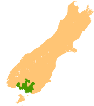
The Southland Plains is a general name given to several areas of low-lying land in the South Island of New Zealand, separated by the rise of the Hokonui Hills in the north. It forms a sizeable area of Southland region and encompasses its two principal settlements the city of Invercargill and the town of Gore. The Southland Plains include some of New Zealand's most fertile farmland.

Toetoes Bay is the easternmost of three large bays lying on the Foveaux Strait coast of Southland, New Zealand, the others being Te Waewae Bay and Oreti Beach. The 240 km Mataura River drains to sea at Toetoes Bay, first passing through the Toetoes Harbour estuary. Thirty kilometres in length, the bay is the southern end of the Awarua Plain, an area of swampy land stretching inland for about fifteen kilometres. The eastern end of the bay is close to Slope Point, the South Island's southernmost point, and the western end of the Catlins.
The Mokoreta River is a river in Southland, New Zealand. A tributary of the Mataura River, its source is between Mt Rosebery and Catlins Cone, close to the source of the Catlins River. It flows westward from the Catlins Ranges into the Southland Plains. Its total length is 50 kilometres (31 mi), and it flows into the Mataura River about 5 kilometres (3 mi) south of the town of Wyndham.

Waipapa Point is a rocky promontory on the south coast of Foveaux Strait, the South Island of New Zealand. It is located 10 kilometres (6.2 mi) southeast of the mouth of the Mataura River, at the extreme southwestern end of the area known as the Catlins.

The Southland Province was a province of New Zealand from March 1861, when it split from Otago Province, until 1870, when it rejoined Otago.

Dacre is a small town in the South Island of New Zealand. It is situated on the Southland Plains between Invercargill and Edendale on State Highway 1. In Dacre, SH 1 is met by State Highway 98, which runs west to Makarewa via Rakahouka. Nearby villages include Mabel Bush to the northwest and Woodlands to the southeast. Dacre is 25 km north east of Invercargill, the closest city. The Main South Line railway passes just to the south of Dacre. It is a dairy farming community, that currently has a community hall and a small engine garage.

Mabel Bush is a small community in the Southland region of New Zealand's South Island. The community has an estimated population of 127 people. The main building in the area is the Mabel Bush Hall, which consists of the hall and tennis courts. The Hall is mainly used for parties and community events.
Springhills is a locality in the central Southland region of New Zealand's South Island. Situated in a gap between Forest Hill and the Hokonui Hills, it is located on State Highway 96 29 kilometres west of State Highway 1 near Mataura and 15 kilometres east of State Highway 6 at Winton.
Longbush is a community in the Southland region of New Zealand's South Island. It is located in a rural area outside the city of Invercargill on the banks of the Waihopai River. Just to the northeast is the larger town of Woodlands.There are two possible origins of the name Longbush, with one being that it is simply named after the shape of the bush. The second, however, is that it was named by the first travellers between Invercargill and Dunedin "and used the term as an indication of the length and weariness of the journey."

Glencoe is a locality in the central Southland region of New Zealand's South Island. Named after Glen Coe in Scotland, it is situated in the Hokonui Hills on the route of State Highway 96 as it travels between Hedgehope and Waitane. The nearest town of significant size is Mataura to the east, while the city of Invercargill is to the southwest.
Waitane is a locality in the Southland region of New Zealand's South Island in the foothills of the Hokonui Hills. It is located in a rural setting on State Highway 96 between Glencoe and Te Tipua. The nearest sizeable town is Mataura to the east, while the main city of Southland, Invercargill, is southwest.
Te Tipua is a rural farming community in the eastern Southland region of New Zealand's South Island.
Te Peka is a locality in the Southland region of New Zealand's South Island. It is situated on the western edge of the Catlins region, with Waimahaka to the west, Fortrose to the southwest, and Pukewao and Tokanui to the southeast.
Waimahaka is a locality in the Southland region of New Zealand's South Island. It is situated in a rural area, inland from Toetoes Bay. Nearby settlements include Pine Bush and Titiroa to the northwest, Fortification and Te Peka to the east, Pukewao and Tokanui to the southwest, and Fortrose on the coast to the south.
Titiroa is a locality in the Southland region of New Zealand's South Island. It is on the eastern bank of the lower Mataura River, inland from Toetoes Bay. Pine Bush is nearby to the northeast, and Waimahaka is to the southeast.
Gorge Road is a locality in the Southland region of New Zealand's South Island. It is on the Southern Scenic Route and is situated on the western bank of the Mataura River. Nearby settlements include Ashers to the west, and across the Mataura, Pine Bush and Titiroa to the east.
Kapuka is a locality in the Southland region of New Zealand's South Island. It is situated between Mokotua to the west and Ashers to the east on the Southern Scenic Route; Oteramika is to the north, and Kapuka South, Waituna Lagoon, and Toetoes Bay are to the south.

The Waikaia River is a river in New Zealand, a tributary of the Mataura River. The name is probably a corruption of Wai-o-Whakaea.
Mataura Island is a farming community in Southland, New Zealand. It is located close to the east bank of the lower reaches of the Mataura River. Despite its name, it is no longer an island. Mataura Island is located some 40 kilometres (25 mi) east of the region's main city of Invercargill, and 15 kilometres (9.3 mi) south of the town of Edendale, on the Awarua Plains and close to the western edge of The Catlins.
Southland County was one of the counties of New Zealand in the South Island. Created in 1876, it was in the eastern part of Southland Region. The surrounding counties were Wallace County, Lake County, Vincent County, Tuapeka County and Clutha County. Within the county, but not part of it, were the city of Invercargill, where the county headquarters were located, and the boroughs of Bluff, Winton, Gore and Mataura, as well as the town district of Wyndham; Lumsden, on the boundary with Wallace County, had its own boundary. The county was abolished in 1989, with most of it being merged into Southland District, the exceptions were the Gore and Mataura areas taken into Gore District, and Bluff became part of Invercargill, which had its boundaries expanded considerably; many places near Invercargill, formerly in the county, became part of the city.
