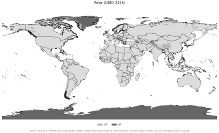
The polar climate regions are characterized by a lack of warm summers but with varying winters. Every month a polar climate has an average temperature of less than 10 °C (50 °F). Regions with a polar climate cover more than 20% of the Earth's area. Most of these regions are far from the equator and near the poles, and in this case, winter days are extremely short and summer days are extremely long. A polar climate consists of cool summers and very cold winters, which results in treeless tundra, glaciers, or a permanent or semi-permanent layer of ice. It is identified with the letter E in the Köppen climate classification.

Matinicus Isle is an island plantation in Knox County, Maine, United States. The island is located within Penobscot Bay about 20 miles east of the mainland coast and is accessible by state ferry service from Rockland or by air taxi from Knox County Regional Airport. Matinicus is the farthest inhabited land off the east coast into the Atlantic Ocean which is part of the United States. The plantation is both a year-round island community and a summer colony. The population was 53 at the 2020 census.

Alpine tundra is a type of natural region or biome that does not contain trees because it is at high elevation, with an associated harsh climate. As the latitude of a location approaches the poles, the threshold elevation for alpine tundra gets lower until it reaches sea level, and alpine tundra merges with polar tundra.

A Mediterranean climate, also called a dry summer climate, described by Köppen as Cs, is a temperate climate type that occurs in the lower mid-latitudes. Such climates typically have dry summers and wet winters, with summer conditions ranging from warm to hot and winter conditions typically being mild to cool. These weather conditions are typically experienced in the majority of Mediterranean-climate regions and countries, but remain highly dependent on proximity to the ocean, altitude and geographical location.

The Chihuahuan Desert is a desert ecoregion designation covering parts of northern Mexico and the southwestern United States. It occupies much of far West Texas, the middle to lower Rio Grande Valley and the lower Pecos Valley in New Mexico, and a portion of southeastern Arizona, as well as the central and northern portions of the Mexican Plateau. It is bordered on the west by the Sonoran Desert, the Colorado Plateau, and the extensive Sierra Madre Occidental range, along with northwestern lowlands of the Sierra Madre Oriental range. Its largest, continual expanse is located in Mexico, covering a large portion of the state of Chihuahua, along with portions of Coahuila, north-eastern Durango, the extreme northern part of Zacatecas, and small western portions of Nuevo León. With an area of about 501,896 km2 (193,783 sq mi), it is the largest hot desert in North America. The desert is fairly young, existing for only 8000 years.

Tropical climate is the first of the five major climate groups in the Köppen climate classification identified with the letter A. Tropical climates are defined by a monthly average temperature of 18 °C (64 °F) or higher in the coolest month, featuring hot temperatures and high humidity all year-round. Annual precipitation is often abundant in tropical climates, and shows a seasonal rhythm but may have seasonal dryness to varying degrees. There are normally only two seasons in tropical climates, a wet (rainy/monsoon) season and a dry season. The annual temperature range in tropical climates is normally very small. Sunlight is intense in these climates.

Nockamixon State Park is a Pennsylvania state park on 5,283 acres (2,138 ha) in Bedminster and Haycock Townships in northern Bucks County, Pennsylvania, in the United States. The park is one of the most popular in southeastern Pennsylvania, with most tourists visiting in the summer months.
Bourail is a commune in the South Province of New Caledonia, an overseas territory of France in the Pacific Ocean.

St. Louis is located at 38°38′53″N90°12′44″W.

The East Potrillo Mountains are a mountain range in south central Doña Ana County, New Mexico. They are located approximately 25 miles (40 km) west of El Paso, Texas, 30 miles (48 km) southwest of Las Cruces, New Mexico, and 30 miles east of Columbus, New Mexico. The southern tip of the range is less than 5 miles (8.0 km) from the Mexican border. The mountains and most of the surrounding acreage are located on land owned by the Bureau of Land Management. Access to the general vicinity is through New Mexico State Road 9, and several unpaved county roads.
Rakahouka is a community in the Southland region of New Zealand's South Island. It is located in a fertile farming area on the Southland Plains just south of the Makarewa River. The nearest major city, Invercargill, is approximately 15 km to the southwest, and nearby villages include Grove Bush and Mabel Bush to the north, Woodlands to the southeast, and Myross Bush and Roslyn Bush to the southwest.

About 1,702 species of plants live on the Arctic tundra, including flowering plants, short shrubs, herbs, grasses, and mosses. These plants are adapted to short, cold growing seasons. They have the ability to withstand extremely cold temperatures in the winter, and grow and reproduce in summer conditions that are quite limiting.

The climate of New Zealand is varied due to the country's diverse landscape. Most regions of New Zealand belong to the temperate zone with a maritime climate characterised by four distinct seasons. Winters are relatively mild and summers comparatively cool. The main contributing factors are the Pacific Ocean and latitude, although the mountain ranges can cause significant climate variations in locations barely tens of kilometres from each other. Conditions vary from extremely wet on the West Coast of the South Island to almost semi-arid in Central Otago and subtropical in Northland.
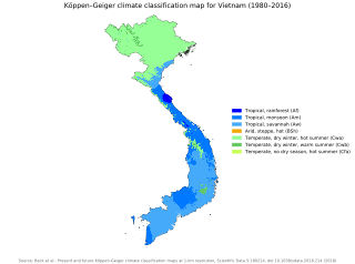
Vietnam has a monsoon-influenced climate typical of that of mainland Southeast Asia. The diverse topography, long latitude, and influences from the South China Sea lead to climatic conditions varying significantly between regions. The northern region experiences a monsoonal and temperate climate (Cfa) with four distinct seasons with winters typically dry and summers ranging from hot to mild. In southern and central areas, the climate is tropical monsoon (Aw) with only two seasons. In addition, a temperate climate exists in mountainous areas, which are found in Sa Pa and Da Lat, while a more continental climate exists in Lai Châu Province and Sơn La Province.
The Alpine-steppe is a high altitude natural alpine grassland, which is a part of the Montane grasslands and shrublands biome.

Liawenee is a small town in Tasmania, Australia built near Great Lake and the River Ouse, and was established on 11 June 1920. The town is an ex-Hydro village and now a residence for Inland Fisheries Services (IFS) and a Tasmania Police station. It is known for its exceptional fishing at nearby Great Lake and hosts several trout fishing events.
The Ngel Nyaki Forest Reserve, whose site is historically known as Majang, is situated on the Mambilla Plateau in North East Nigeria, covering 46 km2. It can be reached on foot from Yelwa village past the Mayo Jigawal, from where it is less than half an hour’s walk to the upper edge of the forest. The elevation ranges from 1,400 metres (4,593 ft) to 1,600 metres (5,249 ft). Ngel Nyaki was formally gazetted a local authority Forest Reserve under Gashaka - Mambilla Native Authority Forest order of April 1969, but presently it is under the management of the Taraba State Government and the Nigerian Conservation Foundation (NCF), with the Nigerian Montane Forest Project (NMFP) as a project partner.

The Kazakh semi-desert is an ecoregion in the deserts and xeric shrublands biome, located in Kazakhstan. The climate is semi-arid and continental, with a total annual precipitation of 160 millimetres (6.3 in), and mean temperatures in January averaging −15 °C (5 °F) and in July 23 °C (73 °F). It is a transitional area between the steppes and the deserts of Central Asia and supports flora found in both biomes, predominantly grasses, particularly Stipa species, and shrubs such as Artemisia species. A number of mammals and birds are found in this ecoregion but the habitat is threatened by overgrazing and fragmentation from human encroachment. However, a recent reduction in livestock numbers in Kazakhstan is allowing the native plants a greater opportunity to regenerate.

The Charcoal Tank Nature Reserve is a protected nature reserve in the central western region of New South Wales, Australia. The 86.4-hectare (213-acre) reserve is situated 10 kilometres (6.2 mi) south of West Wyalong and may be accessed via the Newell Highway and The Charcoal Tank Road. The reserve is an important refuge for native flora and fauna in a highly fragmented landscape, one in which the majority of the original vegetation has been removed.
The Sierra de Huautla is a mountain range and biosphere reserve in central Mexico. Located in southern Morelos, the Sierra de Huautla is a southern extension of the Trans-Mexican Volcanic Belt range into the Balsas Basin. The dry forests of Sierra are home to a diverse community of animals and plants, and the reserve's outstanding biodiversity is recognized by UNESCO.

