Related Research Articles
Fortrose is a locality on the southernmost coast of the South Island of New Zealand in the Southland region. It is situated on Toetoes Bay at the mouth of the Mataura River, and is on the far western edge of the Catlins. Nearby settlements include Otara to the southeast, Pukewao and Tokanui to the northeast, and Titiroa and Waimahaka to the north.
Makarewa is a small community north of Invercargill.
The Tokanui Branch, also known as the Seaward Bush Branch, was a branch line railway located in Southland, New Zealand. It diverged from the Bluff Branch south of the main railway station in Invercargill and ran for 54 kilometres in a southeasterly direction. Construction began in 1883 and it operated until 1966.
The Kingston Branch was a major railway line in Southland, New Zealand. It formed part of New Zealand's national rail network for over a century: construction began in 1864, Kingston was reached in 1878, and it closed in 1979. For much of its life, it was considered a secondary main line rather than a branch line, and in its earlier years, it was sometimes known as the "Great Northern Railway". Today, the southern portion now forms a part of the Wairio Branch and the northernmost 14 kilometres was used by the Kingston Flyer.
The Tuatapere Branch, including the Orawia Branch, was a branch line railway in Southland, New Zealand. Although the Tuatapere and Orawia Branches look like a single line, operationally they were considered separate lines. The first section opened to Riverton in 1879 and reached Tuatapere three decades later. The extension from Tuatapere to Orawia operated from 1925 until 1970. In 1976 the Tuatapere Branch was truncated to Riverton, and was known as the Riverton Branch until 1978, when it closed beyond Thornbury. The remaining portion of the line is now part of the Wairio Branch.
The Ohai Line, formerly known as the Ohai Industrial Line and previously the Wairio Branch and the Ohai Railway Board's line, is a 54.5 km branch line railway in Southland, New Zealand. It opened in 1882 and is one of two remaining branch lines in Southland, and one of only a few in the country. A number of smaller privately owned railways fanned out from Wairio; one of these lines, to Ohai, was originally built by the Ohai Railway Board and was worked by New Zealand Railways from 1990 and incorporated into the national network in 1992.
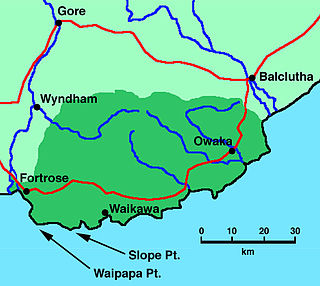
Tokanui is a community in the eastern portion of Southland District Council, located on the Southern Scenic Route about 56 km (35 mi) east of Invercargill and 107 km (66 mi) southwest of Balclutha, New Zealand. The Tokanui River runs just to the north of the village and occasionally floods the lower parts, as it did when the railway yard flooded in 1935.
Browns is a locality in Central Southland in New Zealand's South Island. It is just to the east of the town of Winton in the southwestern reaches of the Hokonui Hills. State Highway 96 passes through the town on its route between Winton and Springhills.
Springhills is a locality in the central Southland region of New Zealand's South Island. Situated in a gap between Forest Hill and the Hokonui Hills, it is located on State Highway 96 29 kilometres west of State Highway 1 near Mataura and 15 kilometres east of State Highway 6 at Winton.
Longbush is a community in the Southland region of New Zealand's South Island. It is located in a rural area outside the city of Invercargill on the banks of the Waihopai River. Just to the northeast is the larger town of Woodlands.There are two possible origins of the name Longbush, with one being that it is simply named after the shape of the bush. The second, however, is that it was named by the first travellers between Invercargill and Dunedin "and used the term as an indication of the length and weariness of the journey."
Pukewao is a locality in the southeastern corner of the Southland region of New Zealand's South Island. It is located inland from Toetoes Bay in the very western part of the Catlins, and nearby settlements include Tokanui to the southeast, Fortrose on the coast to the southwest, and Te Peka and Waimahaka to the northwest.
Te Peka is a locality in the Southland region of New Zealand's South Island. It is situated on the western edge of the Catlins region, with Waimahaka to the west, Fortrose to the southwest, and Pukewao and Tokanui to the southeast.
Waimahaka is a locality in the Southland region of New Zealand's South Island. It is situated in a rural area, inland from Toetoes Bay. Nearby settlements include Pine Bush and Titiroa to the northwest, Fortification and Te Peka to the east, Pukewao and Tokanui to the southwest, and Fortrose on the coast to the south.
Fortification is a locality in the western part of the Catlins region of Southland in New Zealand's South Island. Nearby settlements include Quarry Hills and Waikawa to the southeast, Tokanui to the southwest, and Waimahaka to the west. It is over 50 km east of Southland's main centre, Invercargill.
Gorge Road is a locality in the Southland region of New Zealand's South Island. It is on the Southern Scenic Route and is situated on the western bank of the Mataura River. Nearby settlements include Ashers to the west, and across the Mataura, Pine Bush and Titiroa to the east.
Pine Bush is a locality in the Southland region of New Zealand's South Island.
Ashers is a locality in the Southland region of New Zealand's South Island. It is situated east of Invercargill on the Southern Scenic Route as it runs between Kapuka and Gorge Road. Other nearby settlements include Oteramika to the north and Kapuka South to the south. Also south is the Waituna Lagoon and Toetoes Bay.
Kapuka is a locality in the Southland region of New Zealand's South Island. It is situated between Mokotua to the west and Ashers to the east on the Southern Scenic Route; Oteramika is to the north, and Kapuka South, Waituna Lagoon, and Toetoes Bay are to the south.
Mokotua is a locality in the Southland region of New Zealand's South Island. It is situated in a rural area east of Invercargill, between Timpanys and Kapuka on the Southern Scenic Route. To the south are Toetoes Bay and Waituna Lagoon; Rimu is to the north.
Timpanys is a locality in the Southland region of New Zealand's South Island. It is situated in a rural area east of Invercargill and is on the Southern Scenic Route between Waimatua and Mokotua. Rimu is to the north and Waituna Lagoon and Tiwai Point are to the south.
References
- ↑ "Place name detail: Titiroa". New Zealand Gazetteer. New Zealand Geographic Board . Retrieved 16 November 2007.
- ↑ New Zealand Railway and Tramway Atlas, fourth edition, edited by John Yonge (Essex: Quail Map Company, 1993), 30.
- ↑ David Leitch and Brian Scott, Exploring New Zealand's Ghost Railways, revised edition (Wellington: Grantham House, 1998 [1995]), 125-6.
46°29′S168°46′E / 46.483°S 168.767°E
| | This Southland Region geography article is a stub. You can help Wikipedia by expanding it. |