Milford Sound / Piopiotahi is a fiord in the south west of New Zealand's South Island within Fiordland National Park, Piopiotahi Marine Reserve, and the Te Wahipounamu World Heritage site. It has been judged the world's top travel destination in an international survey and is acclaimed as New Zealand's most famous tourist destination. Rudyard Kipling had previously called it the eighth Wonder of the World.

Lake Manapōuri is located in the South Island of New Zealand. The lake is situated within the Fiordland National Park and the wider region of Te Wahipounamu South West New Zealand World Heritage Area.

Te Anau is a town in the Southland region of the South Island of New Zealand. It is on the eastern shore of Lake Te Anau in Fiordland. Lake Te Anau is the largest lake in the South Island and within New Zealand second only to Lake Taupo. The 2013 census recorded the town's population as 1,911. The town has a wide range of accommodation, with over 4,000 beds available in summer.

Manapouri is a small town in Southland / Fiordland, in the southwest corner of the South Island, in New Zealand. The township is the westernmost municipality in New Zealand. Located at the edge of the Fiordland National Park, on the eastern shore of Lake Manapouri, close to its outflow into the Waiau River, tourist boat services are based in the town.

Lake Hauroko is located in a mountain valley in Fiordland National Park in the South Island of New Zealand. The long S-shaped lake is 30 kilometres in length and covers an area of 63 km². The surface is at an altitude of 150 metres (490 ft) above sea level, and the lake is 462 metres (1,516 ft) deep. It is New Zealand's deepest lake.

Waiau River is the largest river in the Southland Region of New Zealand. It is the outflow of Lake Te Anau, flowing from it into Lake Manapouri 10 kilometres (6 mi) to the south, and from there flows south for 70 kilometres (43 mi) before reaching the Foveaux Strait 8 kilometres (5 mi) south of Tuatapere. It also takes water from Lake Monowai.
Fiordland College is a co-educational state secondary school for years 7–13 students. It is one of the two schools in Te Anau, New Zealand. Te Anau is situated on the shores of Lake Te Anau, at the gateway to New Zealand's largest National Park - Fiordland National Park. Fiordland College is very involved in environmental education. It has been involved in the Kids Restore the Kepler project for a number of years. Through this, students are offered a vast range of opportunities including wildlife encounters, conservation projects and personal developments opportunities.

The Kepler Track is a 60 km (37 mi) circular tramping track which travels through the landscape of the South Island of New Zealand and is situated near the town of Te Anau. The track passes through many landscapes of the Fiordland National Park such as rocky mountain ridges, tall mossy forests, lake shores, deep gorges, rare wetlands and rivers. Like the mountains it traverses, the track is named after Johannes Kepler. The track is one of the New Zealand Great Walks and is administered by New Zealand Department of Conservation (DOC).

The Southern Scenic Route is a tourist highway in New Zealand linking Queenstown, Fiordland, Te Anau and the iconic Milford Road to Dunedin via, Riverton, Invercargill and The Catlins. An Australian travel magazine labelled it "one of the world's great undiscovered drives" in 2008.

Real Journeys is a major South Island and New Zealand award-winning tourism company, privately owned by the Hutchins family since 1954. It operates world renowned cruises in Milford and Doubtful Sounds, the legendary vintage steamship TSS Earnslaw on Lake Wakatipu, the Te Anau-au glowworm caves, Stewart Island ferry services, excursions and lodge accommodation as well as Cardrona Alpine Resort and the International Antarctic Centre and is recognised as one of the most influential contributors to the country’s international tourism profile.
Titiroa is a locality in the Southland Region of New Zealand's South Island. It is on the eastern bank of the lower Mataura River, inland from Toetoes Bay. Pine Bush is nearby to the northeast, and Waimahaka is to the southeast.

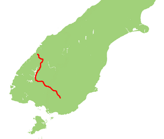
State Highway 94 is a New Zealand state highway connecting the large Southland town of Gore with one of New Zealand's most popular destinations, Milford Sound. It also passes the significant townships of Lumsden and Te Anau as well going through the Homer Tunnel. The road also goes through Fiordland and crosses the Main Divide of the Southern Alps.

The Fiordland Trails Trust, New Zealand, was formed in March 2007, and is an Organisation, with Charitable and Donee Status. The Group was set up in response to the need for a recreational cycleway linking the Towns of Manapouri and Te Anau, much of which has high scenic and recreational values. The Trust aims to construct, Fund and Maintain regional multi use trails for the Department of Conservation In the Fiordland and Northern Southland area.

State Highway 95 is a New Zealand state highway connecting the town of Manapouri with Te Anau at State Highway 94. The highway is a major tourist road and skirts the eastern border of Fiordland National Park between Lake Te Anau and Lake Manapouri. Despite affording views of the scenic mountain ranges of Fiordland, the road itself is largely flat and passes through agricultural land. The entire length of the road lies on the Southern Scenic Route between Queenstown and Dunedin via Invercargill.

Te Anau Airport, Manapouri serves the towns of Te Anau and Manapouri. It is not to be confused with the former and now closed Te Anau aerodrome located just south of that town.

The Southern Lakes is an unofficial name given to an area of the southern South Island of New Zealand. Despite being an unofficial designation, the term Southern Lakes is widely used by organisations such as the New Zealand Meteorological Service and Automobile Association. Though exact definitions vary, the area encompasses parts of western Southland and Central Otago, and is occasionally extended to include the Mackenzie Basin of inland Canterbury, a total of roughly 28,000 to 35,000 square kilometres.

The 2003 Fiordland earthquake struck the remote region of Fiordland in the South Island of New Zealand on 22 August 2003 at 0.12 am. The epicentre was 12 km deep, and was thought to be near Secretary Island at the entrance to Doubtful Sound. This was the same location as an earthquake of 6.7 Ms magnitude in 10 August 1993.


