Queen Elizabeth Park, Kapiti Coast

Last updated

Queen Elizabeth Park
Queen Elizabeth Park, New Zealand.jpg
Queen Elizabeth Park, looking towards State Highway One
Queen Elizabeth Park, Kapiti Coast
TypeRegional park
Location Kapiti Coast, New Zealand
Coordinates 40°57′54″S174°58′10″E / 40.964928°S 174.969335°E / -40.964928; 174.969335
Area638 hectares (1,580 acres)
Created1953
Operated by Wellington Regional Council
Open8am-dusk
StatusOpen

Queen Elizabeth Park is a regional park located on the Kapiti Coast in New Zealand. The park is managed by the Greater Wellington Regional Council and contains the last area of natural dunes on the Kapiti Coast. [1] Facilities and attractions at the park include walkways, a restored wetland, a campground, a visitor centre, the Wellington Tramway Museum, and an area for equestrian activities.

Contents

Geography

The park is bordered by Paekākāriki, Raumati South, two state highways (SH 1 and SH 59), and the North Island Main Trunk Railway.

The main entrance is at Mackays Crossing; secondary entrances are in Raumati South and Paekākāriki. [1]

History

The park is steeped in history including pā sites at Whareroa Beach and Wainui Beach. The tangata whenua of the park are Ngati Haumia, a hapu of the Ngāti Toa iwi and Te Atiawa ki Whakarongotai, [2] who occupied the area for hundreds of years until the mid-19th century. [3]

The number of European settlers grew during the 1830s, and European farmers started to dominate the area from the mid-1850s. [3]

During World War II, the park was the location of two United States Army and Marines bases, Camp MacKay and Camp Russell. U.S. troops were stationed at the camps in 1942–44 prior to being sent into combat in the Pacific Ocean theatre. Today, little evidence of the 20,000 strong military camps remains. [2] [4] A group of facades represents the huts of the marines who lived in the area during World War II, and there is also a sculpture memorial to ten marines who died when a vessel sank offshore. [5]

The park was named for Queen Elizabeth II before her coronation and was opened during the 1953 Royal Visit. Many recreation facilities were developed in the 1950s and 1960s. [2]

The park has legal protection as a recreation reserve under the Reserves Act 1977. [6]

Restoration of wetland

Wetland scene at Queen Elizabeth Park Wetland scene at Queen Elizabeth Park.jpg
Wetland scene at Queen Elizabeth Park

Two areas of wetland were created within the park in the 2000s near Mackay's Crossing, using excavation and plantings to restore the habitat. There is a renmant of native bush adjacent to the restored wetland. [7]

In 2021, about 25 hectares (62 acres) of highly modified peat land on the north-eastern corner of the park was replanted, to restore it to wetland and native forest by about 2026. [8] [9] Environmentalists wanted other farmland in the regional park to also be restored to wetland. [10]

In December 2021, 200 hectares (490 acres) of land previously leased for grazing stock was retired so that it could be restored. [11]

Visitor centre

Ramaroa Centre - Mackays Crossing, Queen Elizabeth Park Ramaroa Centre - Queen Elizabeth Park -MC 01.jpg
Ramaroa Centre – Mackays Crossing, Queen Elizabeth Park

Plans for the development of the park facilities at the Mackays Crossing entrance were announced in 2012. [12] A visitor centre named Ramaroa was opened in 2017. [13] The complex includes a meeting room with capacity for 60 people, a park ranger office and public toilets. The design of the Ramaroa Centre is unusual and includes a gullwing roof. The architecture takes inspiration from the history of the site, including Māori wharenui and the forms of the tents and huts used in the US Marines camp. [14]

Recreation

Several expansive lawn areas near Whareroa Beach and the southern entrance at Paekākāriki provide plenty of space for picnics and recreational activities. Public toilets are located at the car parks at the end of the road to Whareroa Beach, and near the playground and car parks at the Paekākāriki entrance. [1]

A coastal walkway and an inland walkway run the length of Queen Elizabeth Park from Raumati South to Paekākārikii. Near the main entrance, a loop walkway leads through a wetland area and bush remnant with mature kahikatea. [1]

The park also includes the Wellington Tramway Museum [15] and several campgrounds. [1]

The park is open from 8am to dusk, year-round. Dogs are permitted, but must be kept on a leash in picnic areas and are not permitted on or near farmland. Fireworks are prohibited at all times. [1]

Related Research Articles

<span class="mw-page-title-main">Wellington Region</span> Region of New Zealand

41°17′S174°46′E

<span class="mw-page-title-main">Kāpiti Coast District</span> South-western section of the coast of North Island, New Zealand

The Kāpiti Coast District is a local government district of the Wellington Region in the lower North Island of New Zealand, 50 km north of Wellington City. The district is named after Kapiti Island, a prominent island 5 kilometres (3.1 mi) offshore.

<span class="mw-page-title-main">Raumati South</span> Settlement in Wellington Region, New Zealand

Raumati South is a coastal community on the Kapiti Coast of New Zealand's North Island. It is 50km north-west of Wellington, and immediately south of Raumati Beach and south-west of Paraparaumu. The Maungakotukutuku area is located inland.

<span class="mw-page-title-main">Paekākāriki</span> Settlement in Wellington Region, New Zealand

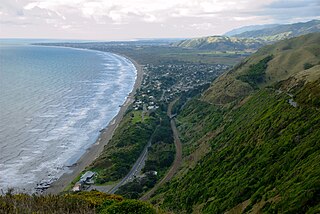
Paekākāriki is a town in the Kapiti Coast District in the south-western North Island, New Zealand, and one of the northernmost suburbs of Wellington. It lies 22 km (14 mi) north of Porirua and 45 km (28 mi) northeast of the Wellington CBD. The town's name comes from the Māori language and can mean "parakeet perch". Paekākāriki had a population of 1,665 at the time of the 2013 census, up 66 from the 2006 census.

<span class="mw-page-title-main">Paraparaumu</span> Town in Wellington Region, New Zealand

Paraparaumu is a town in the south-western North Island of New Zealand. It lies on the Kapiti Coast, 55 kilometres (34 mi) north of the nation's capital city, Wellington.

<span class="mw-page-title-main">Public transport in the Wellington Region</span> Overview of public transport in Wellington, New Zealand

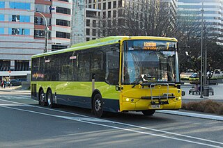
The Wellington Region has a well developed public transport system, the most used in New Zealand. It consists of electric and diesel buses, commuter trains, ferries and a funicular. It also included trams until 1964 and trolleybuses until 2017.

<span class="mw-page-title-main">Kapiti Urban Area</span> Place in Wellington Region, New Zealand

The Kapiti Urban Area is a statistical area that was defined by Statistics New Zealand to cover a group of urban settlements of the Kāpiti Coast District, in the Wellington Region. It was classified as a main urban area under the New Zealand Standard Areas Classification 1992 because its population exceeded 30,000.

Wellington Regional Council, branded as Greater Wellington Regional Council, is the regional council overseeing the Wellington Region of New Zealand's lower North Island. It is responsible for public transport under the brand Metlink, environmental and flood protection, and the region's water supply.

<span class="mw-page-title-main">Kapiti Coast Airport</span> Airport in Paraparaumu, Greater Wellington region

Kapiti Coast Airport, previously called Paraparaumu Airport, is on the Kapiti Coast of New Zealand's North Island, between the Wellington dormitory suburbs of Paraparaumu Beach, Paraparaumu to the east, and Raumati Beach to the south. The Wharemauku Stream flows through part of the airport's land.

<span class="mw-page-title-main">Kapiti Line</span> Wellington commuter rail line

Metlink's Kapiti Line is the electrified southern portion of the North Island Main Trunk railway between New Zealand's capital city, Wellington, and Waikanae on the Kapiti Coast, operated by Transdev Wellington on behalf of Greater Wellington Regional Council. Trains run frequently every day, with stops at 16 stations. Until 20 February 2011 it was known as the Paraparaumu Line.

<span class="mw-page-title-main">Battle Hill Farm Forest Park</span>

Battle Hill Farm Forest Park is a regional park near Paekākāriki, in the Kāpiti Coast District and Wellington Region of New Zealand's lower North Island.

The Wellington local elections, 2010 are part of the 2010 New Zealand local elections, to elect members to sub-national councils and boards. The Wellington elections cover one regional council, eight territorial authority councils, three district health boards, and various community boards and licensing trusts.

<span class="mw-page-title-main">Paekakariki railway station</span> Railway station in New Zealand

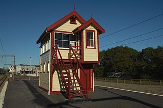
Paekakariki railway station in Paekākāriki on the Kapiti Coast, New Zealand is an intermediate station on the Kapiti Line for Metlink's electric multiple unit commuter trains from Wellington. Paekākāriki was the terminal station of the commuter service from 1940 to 1983, when the service was extended to Paraparaumu, and to Waikanae in 2011.

<span class="mw-page-title-main">Kāpiti Expressway</span> Road in New Zealand

The Kāpiti Expressway is a four-lane grade-separated expressway on New Zealand's State Highway 1 route through the Kapiti Coast north of Wellington. From the northernmost terminus of the Transmission Gully Motorway at Mackays Crossing just north of Paekākāriki, it extends northwards 31 km (19 mi) to just north of Ōtaki, bypassing the former two-lane route through Raumati South, Paraparaumu, Waikanae, Peka Peka, Te Horo and Ōtaki.

Ngā Uruora - Kāpiti Project is a community conservation project set up in Paekākāriki, New Zealand in 1997 by Fergus Wheeler. It is named after the book Ngā Uruora: The Groves of Life - Ecology & History in a New Zealand Landscape by ecologist Geoff Park. The main aims of Ngā Ururoa are protecting and restoring the Kapiti Coast's unique kohekohe forest, re-establishing forests through planting programmes, and undertaking pest and weed control.

<span class="mw-page-title-main">Paekākāriki Hill</span> Rural locality in Porirua, New Zealand

Paekākāriki Hill is a rural locality in Porirua in New Zealand's North Island. It is located inland, behind Paraparaumu and Raumati. Paekākāriki Hill Road runs approximately north to south from Paekākāriki to Pāuatahanui. Grays Road runs along the northern coast of Te Awarua-o-Porirua Harbour's Pauatahunui Arm, which forms the locality's southern boundary.

<span class="mw-page-title-main">Mackays Crossing</span>

Mackays Crossing is a locality in the Kapiti Coast District of New Zealand's North Island, located between Paekākāriki to the south and Raumati South to the north.

The 2022 Wellington local elections were held on 8 October 2022 as part of the wider 2022 New Zealand local elections to elect members to sub-national councils and boards. The Wellington elections cover one regional council, eight territorial authorities, and various community boards and licensing trusts.

References

  1. 1 2 3 4 5 6 "Queen Elizabeth Park". gw.govt.nz. Wellington Regional Council. Archived from the original on 23 October 2021. Retrieved 25 April 2022.
  2. 1 2 3 "Queen Elizabeth Park History". gw.govt.nz. Wellington Regional Council. Archived from the original on 21 December 2019. Retrieved 21 December 2019.
  3. 1 2 Willis, Rosalie (30 December 2019). "Lots to do at Queen Elizabeth Park on Kāpiti Coast". New Zealand Herald. Archived from the original on 12 September 2021. Retrieved 25 April 2022.
  4. "The Camps". nzhistory.net.nz. Ministry for Culture and Heritage. Archived from the original on 21 October 2008. Retrieved 28 December 2008.
  5. Walker, Randall (23 January 2013). "History tour of royal park". Stuff. Archived from the original on 3 October 2022. Retrieved 3 October 2022.
  6. "Queen Elizabeth Park". Land Information New Zealand. Archived from the original on 7 December 2022. Retrieved 7 December 2022.
  7. "Queen Elizabeth Park Resource Statement" (PDF). Greater Wellington Regional Council. November 2008. Archived (PDF) from the original on 9 February 2022. Retrieved 25 April 2022.
  8. "Final planting just the beginning for Queen Elizabeth Park". New Zealand Media and Entertainment. New Zealand Herald. 9 July 2020. Archived from the original on 12 September 2021. Retrieved 25 April 2022.
  9. Gaylor, Penny (30 September 2020). "Restoration work in popular park means big win for environment". New Zealand Media and Entertainment. Kapiti News. Archived from the original on 12 September 2021. Retrieved 25 April 2022.
  10. Wannan, Oliva (3 March 2020). "Queen Elizabeth Park wetlands restoration delay could cost thousands of tonnes of carbon dioxide". New Zealand Media and Entertainment. Dominion Post. Archived from the original on 12 September 2021. Retrieved 25 April 2022.
  11. "Stock grazing to end in Queen Elizabeth Park". RNZ. 11 December 2021. Archived from the original on 3 October 2022. Retrieved 3 October 2022.
  12. Maxwell, Joel (12 September 2012). "Queen Elizabeth Park to get $2m revamp". Stuff. Archived from the original on 3 October 2022. Retrieved 3 October 2022.
  13. "Ramaroa opening adds new dimension to Queen Elizabeth Park". Greater Wellington Regional Council. Archived from the original on 3 October 2022. Retrieved 3 October 2022.
  14. "Ramaroa Centre". Greater Wellington Regional Council. Archived from the original on 3 October 2022. Retrieved 3 October 2022.
  15. Thomson, Rebecca (17 December 2015). "Tramways museum keeps trams trundling along". Stuff. Archived from the original on 3 October 2022. Retrieved 3 October 2022.

Commons-logo.svg Media related to Queen Elizabeth Park, Kapiti Coast at Wikimedia Commons Commons-logo.svg Media related to Camp McKay, Paekakariki at Wikimedia Commons