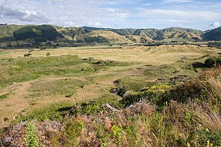
Like other towns in the area, it has a partner settlement at the coast called Paraparaumu Beach, which is directly opposite Kapiti Island. The two towns form part of the Kāpiti Coast District. Together with the nearby Raumati Beach and Raumati South they are among the fastest-growing urban areas in New Zealand, and are major dormitory towns with workers commuting to the cities that make up the Wellington urban area. The four towns between them have a 2012 population of over 49,000 people.[4] Inland behind Paraparaumu is the Maungakotukutuku area.
Paraparaumu is a Māori-language name meaning "scraps from an earth oven"; parapara means "dirt" or "scraps", and umu means "oven".[5]
The village of Lindale is just north of the Paraparaumu town centre. It began as a Tourist and Agricultural Centre, but later gained a reputation for cheese and the Lindale Barnyard petting farm.[6][7][8]
The majority of shops are located close to the town centre in the Coastlands Mall, close to the train station.
Name and etymology
"Parapara" refers in Māori to food waste, and "umu" is ovens that they are cooked in.[10][5] The name Paraparaumu comes from an 1819–1820 expedition of Ngāpuhi and Ngāti Toa, who on the west coast of the North Island from Kāwhia to Cook Strait. As they arrived in the Kāpiti Coast, they found no useful resources.[10]
Paraparaumu is sometimes known by the names "Pram", "Paraparam" or "Pram-Pram".[10]
History
In August 1936 a train derailed in Paraparaumu as it approached a land slide in rainy weather.[11]
Climate
Paraparaumu has an oceanic climate typical of New Zealand, with moderately warm summers and mild winters. It has a quite high rainfall frequency year round, although it is drier than many other coastal areas in the country.
Climate data for Paraparaumu (Kapiti Coast Airport) (1991–2020 normals, extremes 1953–present)
Paraparaumu is defined by Statistics New Zealand as a medium urban area and covers 28.38km2 (10.96sqmi),[1] which includes Otaihanga, Paraparaumu Beach, Raumati Beach and Raumati South. It had an estimated population of 30,300 as of June 2024, with a population density of 1,068 people per km2.
Before the 2023 census, the town had a larger boundary, covering 28.61km2 (11.05sqmi).[1] Using that boundary, Paraparaumu had a population of 28,701 at the 2018 New Zealand census, an increase of 1,866 people (7.0%) since the 2013 census, and an increase of 3,441 people (13.6%) since the 2006 census. There were 11,379 households, comprising 13,560 males and 15,138 females, giving a sex ratio of 0.9 males per female, with 5,199 people (18.1%) aged under 15 years, 4,302 (15.0%) aged 15 to 29, 12,489 (43.5%) aged 30 to 64, and 6,708 (23.4%) aged 65 or older.
Ethnicities were 89.1% European/Pākehā, 12.5% Māori, 3.1% Pasifika, 5.1% Asian, and 2.3% other ethnicities. People may identify with more than one ethnicity.
The percentage of people born overseas was 23.5, compared with 27.1% nationally.
Although some people chose not to answer the census's question about religious affiliation, 54.0% had no religion, 34.7% were Christian, 0.4% had Māori religious beliefs, 0.7% were Hindu, 0.1% were Muslim, 0.6% were Buddhist and 2.2% had other religions.
Of those at least 15 years old, 5,013 (21.3%) people had a bachelor's or higher degree, and 3,876 (16.5%) people had no formal qualifications. 4,329 people (18.4%) earned over $70,000 compared to 17.2% nationally. The employment status of those at least 15 was that 10,368 (44.1%) people were employed full-time, 3,333 (14.2%) were part-time, and 918 (3.9%) were unemployed.[15]
Paraparaumu was formerly represented in soccer/football by Paraparaumu United. They merged with the Raumati Hearts in 2003 to create Kapiti Coast United, which is based at Weka Park in Raumati.
The local athletics club is Paraparaumu Track and Field Club, which has both junior and senior members in conjunction with Athletics Wellington and Athletics New Zealand age grades. The club is based at the Paraparaumu Domain.[28]
Paraparaumu Beach also has a golf course. It has hosted the New Zealand Open a total of 12 times, a record unsurpassed by any other course.[29]
Transport
Airport
Kapiti Coast Airport has a few scheduled commercial flights and is a popular recreational airfield, hosting the Kapiti Aero Club. Air Chathams will have daily flights between the airport and Auckland from 20 August 2018,[30] and Sounds Air operate to Blenheim and Nelson. Now defunct, locally based Air2there used operate to Blenheim and Nelson also. Prior to the mid 2010s Air New Zealand used to have scheduled services to Kapiti Coast Airport with their ATR-42s and Q-400/ DHC-8s. This was then cancelled in the mid 2010s.
There are also feeder and local commuter bus service operated by Metlink.
Education
Primary schools
Paraparaumu School is a co-educational state primary school for Year 1 to 8 Students with a roll of 345 as of November 2024.[31][32]
Paraparaumu Beach School is a co-educational state primary school for Year 1 to 8 Students with a roll of 542 as of November 2024.[31][33]
Kapiti School is a co-educational state primary school for Year 1 to 8 students,[34][35] with a roll of 108 as of November 2024.[36]
Kenakena School is a co-educational state primary school for Year 1 to 8 students,[37][38] with a roll of 591 as of November 2024.[31][39]
Our Lady of Kapiti School is a co-educational state-integrated Catholic primary school for Year 1 to 8 students,[40][41] with a roll of 251 as of November 2024.[31][42] It is named after a large statue of the Virgin Mary located near by.[43]
1 2 "Statistical area 1 dataset for 2018 Census". Statistics New Zealand. March 2020. Paraparaumu Beach North (237000), Paraparaumu Beach West (237100), Paraparaumu Beach East (237300), Otaihanga (237400), Paraparaumu North (237500), Paraparaumu Central (237800), Raumati Beach West (238000), Raumati Beach East (238300), Paraparaumu East (238400) and Raumati South (238500).
Greater Wellington, also known as the Wellington region, is a non-unitary region of New Zealand that occupies the southernmost part of the North Island. The region covers an area of 8,049 square kilometres (3,108 sq mi), and has a population of 550,600.
The Kāpiti Coast District, is a local government district of the Wellington Region in the lower North Island of New Zealand, 50 km (31 mi) north of Wellington City. The district is named after Kapiti Island, a prominent island 5 kilometres (3.1 mi) offshore.
Waikanae is a town on the Kāpiti Coast, 60 km (37 mi) north of the Wellington, New Zealand. The name is a Māori word meaning "waters" (wai) "of the grey mullet".
Ōtaki is a town in the Kāpiti Coast District of the North Island of New Zealand, situated halfway between the capital city Wellington, 70 km (43 mi) to the southwest, and Palmerston North, 70 km (43 mi) to the northeast.
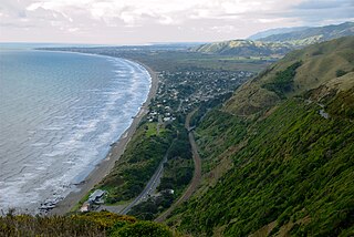
Raumati South is a coastal community on the Kāpiti Coast of New Zealand's North Island. It is 50 km north-west of Wellington, and immediately south of Raumati Beach and south-west of Paraparaumu. The Maungakotukutuku area is located inland.
Raumati Beach is a beach community on the Kāpiti Coast of New Zealand's North Island; located 60km north-west of Wellington, and about 2 km north of Raumati South. It is immediately to the south-west of the larger town of Paraparaumu. The Maungakotukutuku area is located immediately behind Raumati.
Paekākāriki is a town in the Kāpiti Coast District in the south-western North Island, New Zealand, and one of the northernmost towns of the wider Wellington region. It lies 22 km (14 mi) north of Porirua and 45 km (28 mi) northeast of the Wellington CBD. The town's name comes from the Māori language and can mean "parakeet perch". Paekākāriki had a population of 1,665 at the time of the 2013 census, up 66 from the 2006 census.
The Kapiti Urban Area is a statistical area that was defined by Statistics New Zealand to cover a group of urban settlements of the Kāpiti Coast District, in the Wellington Region. It was classified as a main urban area under the New Zealand Standard Areas Classification 1992 because its population exceeded 30,000.
Paraparaumu Beach is a coastal settlement on the Kāpiti Coast of New Zealand's North Island. It is located west of the main Paraparaumu township, 50 km (31 mi) north of Wellington. The area faces Kapiti Island.
Otaihanga is on the Kāpiti Coast of New Zealand's North Island. It is just north of Paraparaumu on the south bank of the Waikanae River and is roughly 55 km north of New Zealand's capital city, Wellington. Its name is Māori for "the place made by the tide".
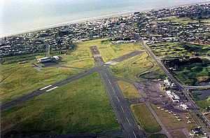
Kapiti Coast Airport, also spelt Kāpiti Coast Airport and previously called Paraparaumu Airport, is on the Kāpiti Coast of New Zealand's North Island, between the Wellington dormitory suburbs of Paraparaumu Beach, Paraparaumu to the east, and Raumati Beach to the south. The Wharemauku Stream flows through part of the airport's land.
Raumati Marine Gardens is a public park in Raumati Beach on New Zealand's Kāpiti Coast. It is near the Tasman Sea just behind the beach, hence its name, and on the northern side of the park, the Wharemauku Stream reaches the ocean.
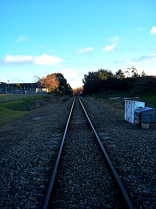
Metlink's Kapiti Line is the electrified southern portion of the North Island Main Trunk railway between New Zealand's capital city, Wellington, and Waikanae on the Kāpiti Coast, operated by Transdev Wellington on behalf of Greater Wellington Regional Council. Trains run frequently every day, with stops at 16 stations. Until 20 February 2011 it was known as the Paraparaumu Line.
Queen Elizabeth Park is a regional park located on the Kāpiti Coast in New Zealand. The park is managed by the Greater Wellington Regional Council and contains the last area of natural dunes on the Kāpiti Coast. Facilities and attractions at the park include walkways, a restored wetland, a campground, a visitor centre, the Wellington Tramway Museum, and an area for equestrian activities.
Kāpiti College is situated at Raumati Beach on the Kāpiti Coast in New Zealand, 45 minutes drive from Wellington City. It was called Raumati District High School when built in 1954, then renamed Kapiti College in 1957. The Kapiti College motto is "Semper Fidelis" which translates to "Always Faithful".
Paraparaumu railway station in Paraparaumu on the Kāpiti Coast, New Zealand is an intermediate station on the Kapiti Line section of the North Island Main Trunk for Metlink's electric multiple unit commuter trains from Wellington. Paraparaumu was the northern terminal for Kapiti Line services from 7 May 1983 until 20 February 2011 when the electrification and Kapiti Line services were extended to Waikanae.
Waikanae railway station in Waikanae on the Kāpiti Coast, New Zealand, is the terminal station on the Kapiti Line for Metlink's electric multiple unit commuter trains from Wellington. The railway is part of the North Island Main Trunk line that connects Wellington and Auckland.
Otaihanga railway station was a flag station between Paraparaumu and Waikanae on the Wellington-Manawatu Line in New Zealand, when the line was run by the Wellington and Manawatu Railway Company. This line is now part of the Kapiti section of the North Island Main Trunk.
Mackays Crossing is a locality in the Kāpiti Coast District of New Zealand's North Island, located between Paekākāriki to the south and Raumati South to the north.
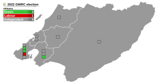
The 2022 Wellington Region local elections were held on 8 October 2022 as part of the wider 2022 New Zealand local elections to elect members to sub-national councils and boards. These elections covered one regional council, eight territorial authorities, and various community boards and licensing trusts.
This page is based on this Wikipedia article Text is available under the CC BY-SA 4.0 license; additional terms may apply. Images, videos and audio are available under their respective licenses.