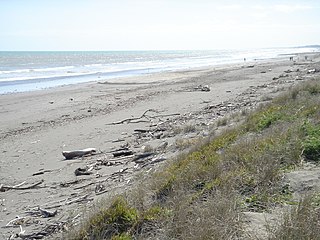
Kapiti Coast District is a local government district in the lower North Island of New Zealand, 50 km north of Wellington.

Waikanae is a town on New Zealand's Kapiti Coast. The name is a Māori word meaning "waters" (wai) "of the yellow-eyed mullet".

Palliser Bay is at the southern end of the North Island of New Zealand, to the southeast of Wellington. It runs for 40 kilometres along the Cook Strait coast from Turakirae Head at the southern end of the Rimutaka Ranges to Cape Palliser, the North Island's southernmost point.

Waikanae River is located on the Kapiti Coast in the North Island of New Zealand.
The Kapiti Urban Area is a statistical area defined by Statistics New Zealand to cover a group of urban settlements on the Kapiti Coast.

Otaihanga is on the Kapiti Coast of New Zealand's North Island. It is just north of Paraparaumu on the south bank of the Waikanae River and is roughly 55 km north of New Zealand's capital city, Wellington. Its name is Māori for "the place made by the tide".
Te Horo and Te Horo Beach are two localities on the Kapiti Coast of New Zealand's North Island. Te Horo Beach is the larger of the two settlements and, as its name implies, is located on the Tasman Sea coast. Te Horo is located to the east, a short distance inland. They are situated between Peka Peka and Waikanae to the south and Otaki to the north. "Te Horo" in the Māori language means "the landslide".

Peka Peka, sometimes Pekapeka, is a lightly populated seaside locality on the Kapiti Coast of New Zealand's North Island. Its population according to the 2001 New Zealand census is 195, an increase of 35.4% or 51 people since the 1996 census. It is located just off State Highway 1 and the North Island Main Trunk railway between Waikanae and Te Horo.
The Maungakotukutuku Stream is a stream on the Kapiti Coast of New Zealand's North Island. Its headwaters are in the Maungakotukutuku area and it is a tributary of the Waikanae River. Consideration has been given to damming the stream in order to increase the Kapiti Coast's water supply.

Reikorangi is a rural locality on the Kapiti Coast in New Zealand's North Island. It is inland, behind Waikanae in the Akatarawa Valley of the Tararua Ranges. The Ngatiawa River and Reikorangi Stream both meet the Waikanae River in Reikorangi. Reikorangi contains a church, a monastery, and formerly contained a school, which closed in 1970 due to the declining population of the small locality.
The Reikorangi Stream is a stream on the Kapiti Coast of New Zealand's North Island. It is one of the Waikanae River's major tributaries. Its headwaters are in the Tararua Ranges near Maungakotukutuku, and it flows north to Reikorangi in the Akatarawa Valley, where it meets the Waikanae River.
The Ngatiawa River is a river on the Kapiti Coast of New Zealand's North Island that is a major tributary of the Waikanae River. Its headwaters are in the Tararua Range and it flows north and northwest through the Akatarawa Valley to Reikorangi, where it meets the Waikanae River.
The Cust River is a river in the Canterbury Region of New Zealand. It flows east across the upper Canterbury Plains from its source north of the town of Oxford, New Zealand, flowing into the Cam River / Ruataniwha close to the town of Rangiora. The small town of Cust lies on the banks of the river. The lower part of the river, to the south-west of Rangiora, is diverted into a channel and called the "Main Drain". The channel was built in 1862 to drain the swampy land between Rangiora and the Waimakariri River, and when it was enlarged in 1868 it accidentally captured the Cust.
The Kopuaranga River is a river of the Wairarapa, in New Zealand's North Island. It flows generally south from rough hill country southwest of Eketahuna, reaching its outflow into the Ruamahanga River 5 kilometres (3 mi) north of Masterton.
The Little Akatarawa River is a river of the Wellington Region of New Zealand's North Island. It is a tributary of the Akatarawa River, which it meets 5 kilometres (3 mi) northwest of Te Marua.
The Waitewaewae River is a river of the Wellington Region of New Zealand's North Island. An upper tributary of the Otaki River, it flows south through Tararua Forest Park to reach the Otaki 20 kilometres (12 mi) east of Waikanae.
The Wharepapa River is a river of the Wellington Region of New Zealand's North Island. It flows south from its sources within Remutaka Forest Park to reach the western end of Palliser Bay close to the small settlement of Wharekauhau.
The Cam River / Ruataniwha is a small river in Canterbury in the South Island of New Zealand. It is a tributary of the Kaiapoi River, itself a tributary of the Waimakariri River.
Waikanae Park is a cricket ground in Waikanae, Wellington, New Zealand. The ground held its first List A match when Central Districts played Auckland in the 1993/94 Shell Cup. The ground later held five further List A matches, the last of which came in the 2004/05 State Shield when Central Districts played Wellington. Central Districts Women used Victoria Park as a home venue in two fixtures in the 2001/02 State League.

Kaiwhaiki is a settlement 18 kilometres (11 mi) upriver from Whanganui, New Zealand.


