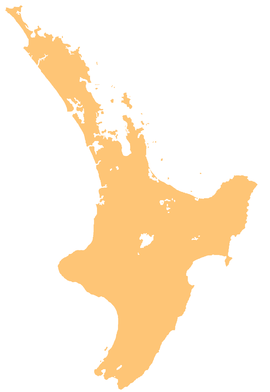
Greater Wellington, also known as the Wellington Region, is a non-unitary region of New Zealand that occupies the southernmost part of the North Island. The region covers an area of 8,049 square kilometres (3,108 sq mi), and has a population of 550,500.

The Kāpiti Coast District, is a local government district of the Wellington Region in the lower North Island of New Zealand, 50 km north of Wellington City. The district is named after Kapiti Island, a prominent island 5 kilometres (3.1 mi) offshore.

The eastern rosella is a rosella native to southeastern Australia, including Tasmania.

Horowhenua District is a territorial authority district on the west coast of the North Island of New Zealand, administered by Horowhenua District Council. Located north of Wellington and Kāpiti, it stretches from slightly north of the town of Ōtaki in the south to just south of Himatangi in the north, and from the coast to the top of the Tararua Range. It is in the Manawatū-Whanganui local government region. The name Horowhenua is Māori for landslide.

The Clarence River is a major river which flows through the Kaikōura Ranges in the northeast of New Zealand's South Island. At roughly 209 kilometres (130 mi) long, it is the longest river in Canterbury and the eighth longest in New Zealand.

The Tararua Range, often referred to as the Tararua Ranges or Tararua, is one of several mountain ranges in the North Island of New Zealand.

Ōtaki is a town in the Kāpiti Coast District of the North Island of New Zealand, situated halfway between the capital city Wellington, 70 km (43 mi) to the southwest, and Palmerston North, 70 km (43 mi) to the northeast.

The Ōtaki River is in the southwestern North Island of New Zealand, located in the Kāpiti Coast District

State Highway 1 is the longest and most significant road in the New Zealand road network, running the length of both main islands. It appears on road maps as SH 1 and on road signs as a white number 1 on a red shield, but it has the official designations SH 1N in the North Island, SH 1S in the South Island.
The Hinds River is a river in the Canterbury region of New Zealand. Its north and south branches drain the eastern flank of the Moorhouse Range, part of the Southern Alps, and their confluence is near Anama and Mayfield. The river then flows across the Canterbury Plains towards the Pacific Ocean, passing through the small town of Hinds along the way. In Hinds, State Highway 1 and the Main South Line railway cross the river. The river's mouth is located between the localities of Longbeach and Lowcliffe.

James Thorn was a New Zealand politician and trade unionist. He was an organiser and candidate for the Independent Political Labour League, Social Democratic Party then the Labour Party.

Ōtaki is a New Zealand Parliamentary electorate, spanning part of the west coast of the lower North Island. The bulk of its population comes from the Horowhenua District, but it also takes in part of the northern Kāpiti Coast, including the towns of Ōtaki and Waikanae, and part of Paraparaumu. The current MP for Ōtaki is Tim Costley of the New Zealand National Party. He has held this position since the 2023 election.
The Eastern Hohonu River is a river of New Zealand. It rises in the Hohonu Range, an outlying range of the Southern Alps 28 kilometres southeast of Greymouth, flowing north then east before reaching its outflow into Lake Brunner. It is named the Eastern Hohonu River to differentiate it from the nearby Big Hohonu River, which is also called the Greenstone River.
The Snowy River is a river of the West Coast Region of New Zealand's South Island. It flows generally west from its sources within Victoria Forest Park, and is one of the rivers whose courses mark the edges of the Ikamatua Plain. The Snowy River joins with the Blackwater River 100 metres prior to its junction with the Māwheraiti River two kilometres north of the township of Ikamatua.
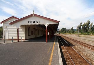
Ōtaki railway station is a station on the North Island Main Trunk railway line serving Ōtaki in the Kapiti Coast District of New Zealand. It is served by the Capital Connection long distance commuter train between Wellington and Palmerston North.

The Humboldt Mountains or Humboldt Range are one of the many ranges which make up the Southern Alps / Kā Tiritiri o te Moana in the South Island of New Zealand. They lie to the northwest of Lake Wakatipu in the Otago Region. Parts of the range lie within Fiordland National Park, and they form the southern extremity of Mount Aspiring National Park. The range was named by early explorer James McKerrow, and like many geographic features worldwide, it was named in honour of notable scientist Alexander von Humboldt.
Taitetimu / Caswell Sound is a fiord of the South Island of New Zealand. It is one of the fiords that form the coast of Fiordland.

The Two Thumb Range is a range of mountains in the Canterbury Region of New Zealand's South Island. It is located to the east of Lake Tekapo and has several peaks which rise to around 2,500 metres (8,200 ft). The southern end of the range contains one of Canterbury's main skifields, Mount Dobson.