
Te Awa Kairangi / Hutt River flows through the southern North Island of New Zealand. It flows south-west from the southern Tararua Range for 56 kilometres (35 mi), forming a number of fertile floodplains, including Kaitoke, central Upper Hutt and Lower Hutt.

Wainuiomata is a large suburb of Lower Hutt, in the Wellington Region of New Zealand's North Island.

The Hunua Ranges is a mountain range and regional park to the southeast of Auckland, in Franklin in the Auckland Region of New Zealand's North Island. The ranges cover some 250 square kilometres (97 sq mi) and rise to 688 metres (2255 ft) at Kohukohunui.
Wellington Regional Council, branded as Greater Wellington Regional Council, is the regional council overseeing the Wellington Region of New Zealand's lower North Island.

Regional parks of New Zealand are protected areas administered by regional councils, the top tier of local government.

Wainuiomata High School, a state co-educational secondary school, operates in Wainuiomata, a suburb of Lower Hutt in New Zealand. The school was founded in January 2002 from the merger of Wainuiomata College and Parkway College. A total of 550 students from Years 9 to 13 attended the school as of November 2021.
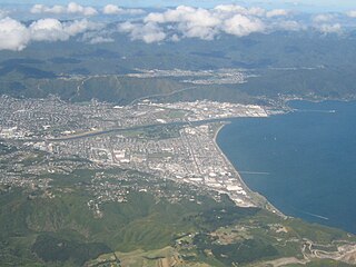
Lower Hutt is a city in the Wellington Region of New Zealand. Administered by the Hutt City Council, it is one of the four cities that constitute the Wellington metropolitan area.
Queen Elizabeth Park is a Wellington Regional Park located on the Kapiti Coast in New Zealand. The park contains the last area of natural dunes on the Kapiti Coast.

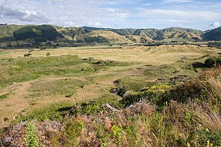
Battle Hill Farm Forest Park is a regional park near Paekakariki, in the Kapiti Coast District and Wellington Region of New Zealand's lower North Island.

Belmont Regional Park is a regional park located between Lower Hutt and Porirua, in the Wellington Region at the southern end of New Zealand's North Island. It is administered by Wellington Regional Council.
East Harbour Regional Park is a regional park stretching from Baring Head along the east side of the Wellington Harbour along the east side of Eastbourne. It is located in Lower Hutt City, in the Wellington Region of New Zealand's North Island.

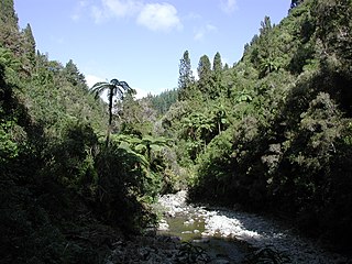
Kaitoke Regional Park is regional park located at Kaitoke, northeast of Upper Hutt, in the Wellington Region of New Zealand's southern North Island. It is administered by Wellington Regional Council, alongside the adjacent regional park of Hutt Water Collection Area.
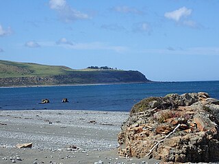
Baring Head / Ōrua-pouanui is a headland, located between Wellington Harbour and Palliser Bay at the southern end of the North Island of New Zealand. It marks the southern end of Fitzroy Bay.
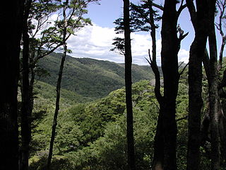
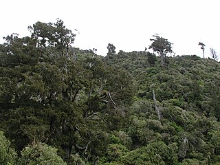
Akatarawa Forest is a regional park in the Upper Hutt within the Wellington Region at the southern tip of the North Island of New Zealand. It encompasses 15,000 hectares of native and plantation forest. It includes the headwaters of the Maungakotukutuku Steam, Akatarawa River West and the Whakatikei River.
Maratoto is a valley and rural community in the Hauraki District and Waikato region of New Zealand's North Island, north of Paeroa.

Hutt Water Collection Area is a regional park located in Upper Hutt in the Wellington Region at the southern end of New Zealand's North Island. It is administered by Wellington Regional Council and is located alongside the larger Kaitoke Regional Park.
Pakuratahi Forest is a regional park located in Upper Hutt in the Wellington Region at the southern end of New Zealand's North Island. It is administered by Wellington Regional Council.
Wainuiomata Water Collection Area is a regional park located near Wainuiomata, Lower Hutt in the Wellington Region at the southern end of New Zealand's North Island. It is administered by Wellington Regional Council, for exclusive use by Wellington Water.

Whitireia Park is a headland north of Titahi Bay and Te Awarua-o-Porirua Harbour in Porirua, in the Wellington Region at the southern end of New Zealand's North Island. It is a regional park administered by Wellington Regional Council.

Waimakariri River Regional Park is a regional park in the Canterbury Region of New Zealand's South Island. It covers 15,000 hectares on the banks of the Waimakariri River, and is operated by Environment Canterbury.
