
Eastbourne is a suburb of Lower Hutt, a part of Wellington, New Zealand. Lying beside the sea, it is a popular local tourist destination via car from Petone or from ferry crossings from central Wellington. An outer suburb, it lies on the eastern shore of Wellington Harbour, five kilometres south of the main Lower Hutt urban area and directly across the harbour from the Miramar Peninsula in Wellington city. A narrow exposed coastal road connects it with the rest of Lower Hutt via the Eastern Bays and the industrial suburb of Seaview. It is named for Eastbourne in England, another seaside town known as a destination for day-trips.
Trentham is the most populous suburb of Upper Hutt, a city in the Wellington region of New Zealand. The suburb is located in a widening of the Hutt Valley, five kilometres to the southwest of the Upper Hutt city centre.

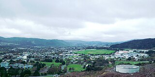
Silverstream is a suburb of Upper Hutt in New Zealand, just under 7 km south-west of the Upper Hutt CBD. It is in the lower (southern) part of the North Island of New Zealand at the southern end of Upper Hutt, close to the Taitā Gorge, which separates Upper Hutt from Lower Hutt. The area is sited at the mouth of a small valley formed by the Wellington Region's tectonic activity and, in part, by Hull's Creek, which discharges into the Hutt River.
Alicetown is a central suburb of Lower Hutt located at the bottom of the North Island of New Zealand.

Belmont, a suburb of Lower Hutt, to the north of Wellington in the North Island of New Zealand, lies on the west bank of the Hutt River, on State Highway 2, the Wellington-Hutt main road, and across the river from the centre of Lower Hutt.

Raphael House Rudolf Steiner School is a coeducational, state integrated composite school in Tirohanga, Lower Hutt. It provides a Waldorf education for Years 1 to 13. Matriculation starts when children are 7 years of age.
Waterloo is an eastern suburb of Lower Hutt, Wellington. It is named after the Battle of Waterloo won by the Duke of Wellington in 1815.

Moera, a suburb of the city of Lower Hutt in New Zealand, forms part of the urban area of greater Wellington.
Ebdentown, a suburb of Upper Hutt located in the lower North Island of New Zealand, near Upper Hutt Central.
Upper Hutt Central is the commercial and geographic focal point of Upper Hutt city, located in the lower North Island of New Zealand.
Hutt Central, a suburb of the city of Lower Hutt in New Zealand, forms part of the urban area of greater Wellington. It includes the Lower Hutt CBD.
Boulcott is a central suburb of Lower Hutt City situated in the south of the North Island of New Zealand. The suburb lies about a kilometre north-east of the Lower Hutt CBD.

Epuni is a suburb of Lower Hutt, New Zealand situated in the south of the North Island of New Zealand. The suburb lies around one kilometre east of the Lower Hutt CBD.
Manor Park, a northern suburb of Lower Hutt City, lies in the south of the North Island of New Zealand. The suburb separates the western bank of the Hutt River from State Highway 2.

Waiwhetū is an eastern suburb of Lower Hutt in the Wellington Region situated in the south of the North Island of New Zealand.
Maungaraki is a suburb of Lower Hutt City situated at the bottom of the North Island of New Zealand. The suburb is located on the western hills of the Hutt Valley with access to the area via State Highway 2 and offers extensive views of Wellington harbour and Matiu/Somes Island. It contains the largest suburban development on the Hutt Valley's western escarpment that runs along the Wellington Fault.
Gracefield is an industrial suburb of Lower Hutt City, located at the bottom of the North Island of New Zealand.

Korokoro, a suburb of Lower Hutt City, lies in the south of the North Island of New Zealand. The suburb occupies part of the western hills of the Hutt Valley; its eastern slopes overlook Petone and the Wellington harbour.

Homedale is a suburb of Wainuiomata, part of Lower Hutt city situated in the lower North Island of New Zealand.

Hastings Central is the central suburb and business district of Hastings City, in the Hawke's Bay Region of New Zealand's North Island.
