Porirua, a city in the Wellington Region of the North Island of New Zealand, is one of the four cities that constitute the Wellington metropolitan area. The name 'Porirua' is a corruption of 'Pari-rua', meaning "the tide sweeping up both reaches". It almost completely surrounds Porirua Harbour at the southern end of the Kāpiti Coast. As of 2023, Porirua has a population of 62,400 people, and is a diverse city with 26.5% of the population identifying as Pasifika and 23.0% of the population identifying as Māori.

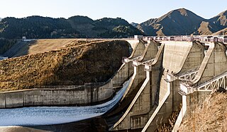
Benmore Dam is the largest dam within the Waitaki power scheme, located in the Canterbury Region of New Zealand's South Island. There are eight other power stations in the Waitaki Power Scheme.
Transpower New Zealand Limited (TPNZ) is the state-owned enterprise responsible for electric power transmission in New Zealand. It performs two major functions in the New Zealand electricity market. As the owner of the National Grid it provides the infrastructure of electric power transmission that allows consumers to have access to generation from a wide range of sources, and enables competition in the wholesale electricity market; as system operator it manages the real-time operation of the grid and the physical operation of the electricity market.
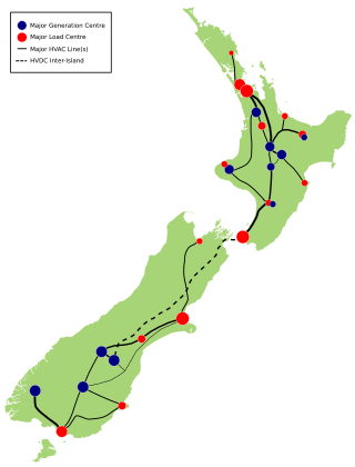
The HVDC Inter-Island link is a 610 km (380 mi) long, 1200 MW high-voltage direct current (HVDC) transmission system connecting the electricity networks of the North Island and South Island of New Zealand together. It is commonly referred to as the Cook Strait cable in the media and in press releases, although the link is much longer than its Cook Strait section. The link is owned and operated by state-owned transmission company Transpower New Zealand.
Melling is a suburb of Lower Hutt, to the north of Wellington in the North Island of New Zealand. It is on the west bank of the Hutt River, on State Highway 2, the Wellington-Hutt main road, and directly across the river from the centre of Lower Hutt. It is also the name of the three-lane bridge connecting the Hutt City central business district with State Highway 2, a route subject to extensive congestion at peak times. From the Melling Bridge it is possible to drive straight ahead into the hill suburbs of Harbour View and Tirohanga.

Pāuatahanui is a village in New Zealand's North Island. It is at the far eastern end of what was known as the Pāuatahanui Inlet, an arm of the Porirua Harbour, northeast of Wellington. In local government terms, Pāuatahanui is part of the Northern Ward of Porirua City.

The Hutt Valley Line is the electrified train service operated by Transdev Wellington on behalf of Metlink on the section of the Wairarapa Line railway between Wellington and Upper Hutt, New Zealand.
The Transmission Gully Motorway is a 27-kilometre-long (17-mile), four-lane motorway north of Wellington, New Zealand; it is part of the State Highway 1 route. Construction began on 8 September 2014 and completion was originally scheduled for April 2020, but contractual negotiations as well as difficulties resulting from the COVID-19 pandemic caused delays. The motorway was officially opened on 30 March 2022 and opened to public traffic the following day.
The electricity sector in New Zealand uses mainly renewable energy, such as hydropower, geothermal power and increasingly wind energy. As of 2021, the country generated 81.2% of its electricity from renewable sources. The strategy of electrification is being pursued to enhance the penetration of renewable energy sources and to reduce greenhouse gas (GHG) emissions across all sectors of the economy. In 2021, electricity consumption reached 40 terawatt-hours (TW⋅h), representing a 0.2% increase compared to the consumption levels in 2010.

State Highway 2 runs north–south through eastern parts of the North Island of New Zealand from the outskirts of Auckland to Wellington. It runs through Tauranga, Gisborne, Napier, Hastings and Masterton. It is the second-longest highway in the North Island, after State Highway 1, which runs the length of both of the country's main islands.

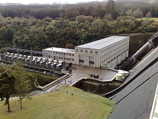
Whakamaru Power Station is a hydroelectric power station on the Waikato River, in the North Island of New Zealand. It is the fourth hydroelectric power station on the Waikato River.

The National Grid is the nationwide system of electric power transmission in New Zealand. The grid is owned, operated and maintained by Transpower New Zealand, a state-owned enterprise, although some lines are owned by local distribution companies and leased to Transpower. In total, the national grid contains 11,803 kilometres (7,334 mi) of high-voltage lines and 178 substations.

Orion New Zealand Limited (Orion) is an electricity distribution company, based in Christchurch, New Zealand.

The Whakamaru to Brownhill Road transmission line is a double-circuit 400 kV-capable transmission line constructed by Transpower to increase the capacity of the National Grid between the southern Waikato and the city of Auckland. The line runs from the Whakamaru sub-station near the Whakamaru Power Station, over a distance of 186 kilometres (116 mi) to the new Brownhill Road substation near Whitford in southeastern Auckland. The line will initially be operated at 220 kV. From Brownhill Road, 220 kV underground cables connect the line to the Pakuranga sub-station in eastern Auckland. The project was the subject of considerable controversy and protest during the planning and approval stages. Construction of the line started in February 2010, and the line was commissioned on 30 October 2012. The transmission line forms the major part of a wider North Island Grid Upgrade project with a forecast cost to completion of $894 million.
The North Auckland and Northland (NAaN) grid upgrade project reinforced transmission into the Auckland Region and across the harbour to North Auckland and the Northland Region. It added new 220 kV transmission capacity to the National Grid by providing 37 km of underground cable between the Pakuranga, Penrose, and Albany substations.
Wellington Electricity, registered as Wellington Electricity Lines Limited, is an electricity distribution company, based in Wellington, New Zealand.

Electricity Ashburton Limited, trading as EA Networks is a co-operatively-owned electricity distribution company, based in Ashburton, New Zealand.
The Haywards–Plimmerton Line was a railway development proposed several times between 1879 and the 1960s to connect the Hutt Valley and Porirua areas of Wellington via Haywards.
State Highway 58 (SH 58) is a New Zealand state highway in the Wellington Region linking the Hutt Valley to Porirua City.
Railway electrification in New Zealand consists of three separate electric systems, all on the North Island. Electrification was initially adopted by the New Zealand Railways for long tunnels; the Otira Tunnel, the Lyttelton Rail Tunnel and the two Tawa Tunnels of the Tawa Flat Deviation. Electrification of Wellington suburban services started with the Johnsonville Line and Kapiti Line out of Wellington from the 1930s. Auckland suburban services were electrified in 2014–2015. Electrification of long-distance services on the North Island Main Trunk (NIMT) dates from 1986. New long tunnels, for example the Rimutaka Tunnel and the Kaimai Tunnel, were operated by diesels, and the Otira and Lyttelton Tunnels have converted to diesel operation.


