Pencarrow Head

Last updated

Pencarrow Head
Pencarrow
Rural area
QE2 at Pencarrow Head, Wellington, New Zealand, 13 Feb. 2007.jpg
Ocean liner Queen Elizabeth 2 at Pencarrow Head
Pencarrow Head
Coordinates: 41°21′34″S174°50′54″E / 41.3594°S 174.8482°E / -41.3594; 174.8482
CountryNew Zealand
Region Wellington Region
Territorial authority Lower Hutt
WardWainuiomata
Electorates
Government
  Territorial Authority Hutt City Council
  Regional council Greater Wellington Regional Council
   Hutt South MP Chris Bishop
   Te Tai Tonga MP Tākuta Ferris
Area
[1]
  Total268.40 km2 (103.63 sq mi)
Population
 (June 2023) [2]
  Total700
  Density2.6/km2 (6.8/sq mi)
Time zone UTC+12 (NZST)
  Summer (DST) UTC+13 (NZDT)
Postcode(s)
5013
Area code 04

Pencarrow Head, also known as Pencarrow, is a headland in the Wellington Region of New Zealand and the name of the surrounding area, which was derived from Pencarrow, the family home of New Zealand Company director, Sir William Molesworth. [3] The name is Cornish and formed from Pen which translates to English as head and Carrow which is a valley. [4]

It is the eastern headland that marks the entrance to Wellington Harbour. The area is located south of Eastbourne and is part of Lower Hutt. The area is hilly and has no road access; a walking and mountain biking track follows the coast line. [5] The head marks the northern end of Fitzroy Bay.

The main attraction of Pencarrow Head is the Pencarrow Head Lighthouse, the first permanent lighthouse in New Zealand constructed in 1859. It is one of Wellington's most notable heritage locations and New Zealand's only female lighthouse keeper, Mary Bennett, worked here. The return walk from Eastbourne takes four hours. [5] [6]

The Pencarrow lakes, Lake Kohangapiripiri and Lake Kohangatera, are freshwater wetlands that were blocked from the sea by earthquake activity. Stock grazing was discontinued in 2004 and the wetlands are recovering from stock and farming impacts. The area is under joint management by the Department of Conservation and the Greater Wellington Regional Council. [7]

Treated effluent from Seaview sewage works is discharged at Pencarrow Head, at the end of a 18 km (11 mi) pipeline built in 1962. [8]

Many ships have been wrecked on the rocks between the Head and Point Hinds to the north, including Henrietta in 1852, [9] Hunter in 1876, [10] Carlotta in 1878, [11] Magic in 1921, [12] Admiral in 1960 [13] and Maria Luisa in 1996, in a collision with Sydney Express . [14]

Demographics

Pencarrow statistical area covers 268.40 km2 (103.63 sq mi). [1] It had an estimated population of 700 as of June 2023, [2] with a population density of 2.6 people per km2.

Historical population
YearPop.±% p.a.
2006573    
2013588+0.37%
2018651+2.06%
Source: [15]

Pencarrow had a population of 651 at the 2018 New Zealand census, an increase of 63 people (10.7%) since the 2013 census, and an increase of 78 people (13.6%) since the 2006 census. There were 228 households, comprising 312 males and 342 females, giving a sex ratio of 0.91 males per female. The median age was 46.2 years (compared with 37.4 years nationally), with 123 people (18.9%) aged under 15 years, 102 (15.7%) aged 15 to 29, 342 (52.5%) aged 30 to 64, and 84 (12.9%) aged 65 or older.

Ethnicities were 88.9% European/Pākehā, 12.9% Māori, 3.7% Pasifika, 5.1% Asian, and 1.8% other ethnicities. People may identify with more than one ethnicity.

The percentage of people born overseas was 18.0, compared with 27.1% nationally.

Although some people chose not to answer the census's question about religious affiliation, 57.1% had no religion, 32.7% were Christian, 0.9% had Māori religious beliefs, 0.9% were Hindu, 0.5% were Muslim, 1.8% were Buddhist and 1.8% had other religions.

Of those at least 15 years old, 87 (16.5%) people had a bachelor's or higher degree, and 105 (19.9%) people had no formal qualifications. The median income was $39,700, compared with $31,800 nationally. 129 people (24.4%) earned over $70,000 compared to 17.2% nationally. The employment status of those at least 15 was that 291 (55.1%) people were employed full-time, 84 (15.9%) were part-time, and 15 (2.8%) were unemployed. [15]

Related Research Articles

<span class="mw-page-title-main">Eastbourne, New Zealand</span> Suburb of Lower Hutt, New Zealand

Eastbourne is a suburb of Lower Hutt, a part of Wellington, New Zealand. Lying beside the sea, it is a popular local tourist destination via car from Petone or from ferry crossings from central Wellington. An outer suburb, it lies on the eastern shore of Wellington Harbour, five kilometres south of the main Lower Hutt urban area and directly across the harbour from the Miramar Peninsula in Wellington city. A narrow exposed coastal road connects it with the rest of Lower Hutt via the Eastern Bays and the industrial suburb of Seaview. It is named for Eastbourne in England, another seaside town known as a destination for day-trips.

Waipukurau is the largest town in the Central Hawke's Bay District on the east coast of the North Island of New Zealand. It is located on the banks of the Tukituki River, 7 kilometres south of Waipawa and 50 kilometres southwest of Hastings.

<span class="mw-page-title-main">Tīrau</span> Settlement in Waikato, New Zealand

Tīrau is a small town in the Waikato region of the North Island of New Zealand, 50 kilometres southeast of Hamilton. The town has a population of 804. In the Māori language, "Tīrau" means "place of many cabbage trees."

<span class="mw-page-title-main">Waipawa</span> Town in Hawkes Bay, New Zealand

Waipawa is the second-largest town in Central Hawke's Bay in the east of the North Island of New Zealand. It has a population of 2,400.

<span class="mw-page-title-main">Hunterville</span> Town in Manawatū-Whanganui, New Zealand

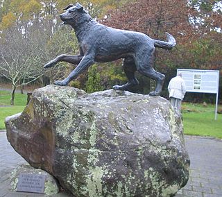
Hunterville is a small town in the Rangitikei district of the North Island of New Zealand. It is located halfway between Taupo and Wellington on State Highway 1, and as of the 2018 census has a population of 408.

<span class="mw-page-title-main">Frankton, Hamilton</span> Suburb of Hamilton, New Zealand

Frankton is a central suburb of the city of Hamilton, New Zealand. It is the site of the city's passenger railway station, a major industrial-commercial stretch of State Highway 1C, and a commercial shopping area. Frankton Borough Council was formed in 1913, but merged with Hamilton in 1917, after a poll in 1916.

<span class="mw-page-title-main">Kaiwharawhara</span> Suburb in Wellington, New Zealand

Kaiwharawhara is an urban seaside suburb of Wellington in New Zealand's North Island. It is located north of the centre of the city on the western shore of Wellington Harbour, where the Kaiwharawhara Stream reaches the sea from its headwaters in Karori. It is a largely commercial and industrial area and thus has little residential population. A recent housing development up the hillside towards Te Kainga has increased the resident population.

Ōtāne is a town in the Central Hawke's Bay District and the Hawke's Bay region, on the east coast of New Zealand's North Island. The small village, has a school, general store, cafe and pub, and is located just off State Highway 2.

<span class="mw-page-title-main">Lower Hutt</span> City in Wellington, New Zealand

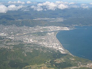
Lower Hutt is a city in the Wellington Region of New Zealand. Administered by the Hutt City Council, it is one of the four cities that constitute the Wellington metropolitan area.

<span class="mw-page-title-main">East Harbour Regional Park</span>

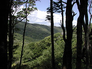
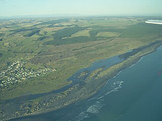
East Harbour Regional Park is a regional park stretching from Baring Head along the east side of the Wellington Harbour along the east side of Eastbourne. It is located in Lower Hutt City, in the Wellington Region of New Zealand's North Island.

<span class="mw-page-title-main">Whitiora</span> Suburb of Hamilton, New Zealand

Whitiora is a suburb in central Hamilton in New Zealand. The suburb is home to Waikato Stadium, formerly Rugby Park. It is a major sporting and cultural events venue in Hamilton with a total capacity of 25,800. The stadium is a multi-purpose facility, though used mainly for rugby union. Many of Hamilton's hotels are in Whitiora, along the main road from the north.

<span class="mw-page-title-main">Otautau</span> Place in Southland region, New Zealand

Otautau is a small farming, forestry and milling town located inland on the western edge of the Southland Plains of New Zealand on the banks of the Aparima River. Otautau is located approximately 40 kilometres (25 mi) north west of Invercargill. The average elevation of Otautau is 60 metres.

<span class="mw-page-title-main">Koitiata</span> Settlement in Manawatū-Whanganui Region, New Zealand

Koitiata is a settlement located in the southwestern part of Rangitikei District of the Manawatū-Whanganui region of New Zealand's North Island. At the time of the 2018 census, Koitiata had a population of 126. Marton is located 24 km to the east and Whanganui is located 29 km to the northwest. Nearby Koitiata is Lake Koitiata.

<span class="mw-page-title-main">Fitzroy Bay (New Zealand)</span>

Fitzroy Bay is a bay close to the entrance of Wellington Harbour in New Zealand. It lies to the southeast of the entrance to the harbour, between Pencarrow Head and Baring Head. Lake Kohangatera drains into the bay through Gollans Stream.

<span class="mw-page-title-main">Whitikahu</span> Locality in Waikato, New Zealand

Whitikahu is a settlement scattered along Whitikahu Rd in the Waikato District and Waikato region of New Zealand's North Island.

<span class="mw-page-title-main">Kawaha Point</span> Suburb of Rotorua, New Zealand

Kawaha Point is a suburb of Rotorua in the Bay of Plenty Region of New Zealand's North Island.

<span class="mw-page-title-main">Eureka, New Zealand</span> Locality in Waikato, New Zealand

Eureka is a rural settlement in the Waikato District and Waikato region of New Zealand's North Island. It is located on State Highway 26, and is surrounded by dairy farmland on a flat plain.

<span class="mw-page-title-main">Castlecliff</span> Suburb of Whanganui

Castlecliff is a suburb of Whanganui, in the Whanganui District and Manawatū-Whanganui region of New Zealand's North Island. The name was given by the Harbour Board, on the suggestion of the future Prime Minister, John Ballance, when it established the township on what were described as "barren sandhills" in 1882. Many of the streets were named after Harbour Board members. The northern harbour breakwater extended 900 ft (270 m) by 1885. The freezing works was built in 1891.

<span class="mw-page-title-main">Piripiri, Manawatū-Whanganui</span> Place in Manawatū-Whanganui, New Zealand

Piripiri is a sparsely populated area in the Manawatū-Whanganui region, on State Highway 2 and the Palmerston North–Gisborne line. It is 3 mi 8 ch (5.0 km) north of Dannevirke, and has 150 people scattered over a meshblock of 21.8 km2 (8.4 sq mi).

<span class="mw-page-title-main">Point Howard</span> Suburb of Lower Hutt, New Zealand

Point Howard is a suburb on the eastern side of Wellington Harbour, in Lower Hutt, New Zealand.

References

  1. 1 2 "ArcGIS Web Application". statsnz.maps.arcgis.com. Retrieved 4 January 2024.
  2. 1 2 "Population estimate tables - NZ.Stat". Statistics New Zealand . Retrieved 25 October 2023.
  3. "Pencarrow Head". gazetteer.linz.govt.nz. 15 April 2013. Retrieved 5 January 2024.
  4. "Pencarrow, Historic Houses in Cornwall, Independent & Unique". www.pencarrow.co.uk. Retrieved 5 January 2024.
  5. 1 2 "Pencarrow Heads Light House Walk". FreeWalks NZ. Retrieved 31 October 2018.
  6. "Pencarrow Coast". Hutt City Council . Retrieved 31 October 2018.
  7. "Pencarrow Lakes". Department of Conservation . Retrieved 31 October 2018.
  8. "The Post". www.thepost.co.nz. 23 September 2023. Retrieved 5 January 2024.
  9. "Wellington Independent". paperspast.natlib.govt.nz. 30 October 1852. Retrieved 5 January 2024.
  10. "Wreck of the Ketch Hunter at the Heads. Evening Post". paperspast.natlib.govt.nz. 8 April 1876. Retrieved 5 January 2024.
  11. "Evening Post". paperspast.natlib.govt.nz. 12 November 1878. Retrieved 5 January 2024.
  12. "On the rocks. Evening Post". paperspast.natlib.govt.nz. 28 March 1921. Retrieved 5 January 2024.
  13. "Trawler on reef. Press". paperspast.natlib.govt.nz. 26 November 1960. Retrieved 5 January 2024.
  14. "Report 96-214 Collision between the container vessel Sydney Express and the fishing trawler Maria Luisa" (PDF). TAIC. 29 December 1996.
  15. 1 2 "Statistical area 1 dataset for 2018 Census". Statistics New Zealand. March 2020. Pencarrow (246800). 2018 Census place summary: Pencarrow